
| Reference: | S46652 |
| Author | Jacques Nicolas BELLIN |
| Year: | 1736 |
| Zone: | Japan, Korea, Kamtchacka |
| Printed: | Paris |
| Measures: | 285 x 340 mm |
| Reference: | S46652 |
| Author | Jacques Nicolas BELLIN |
| Year: | 1736 |
| Zone: | Japan, Korea, Kamtchacka |
| Printed: | Paris |
| Measures: | 285 x 340 mm |
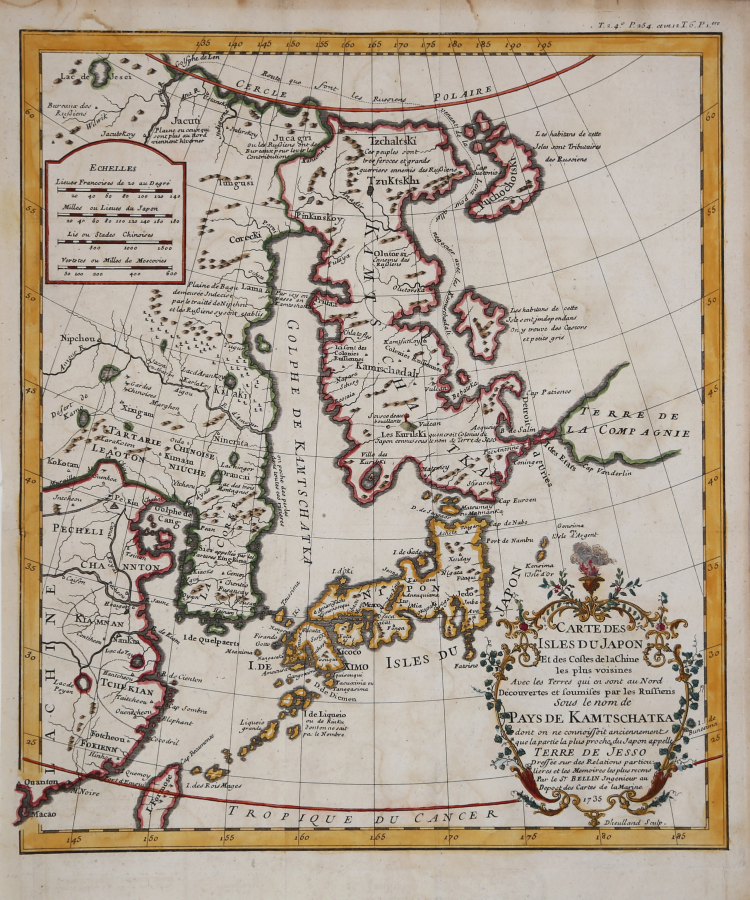
Carte des isles du Japon et des costes de la Chine les plus voisines avec les terres qui en sont au Nord découvertes et soumises par les Russiens sous le nom de pays de Kamtschatka dont on ne connoissoit anciennement que la partie la plus proche du Japon appelle terre de Jesso / dressée sur des relations particulières et les mémoires les plus récens par le Sr. Bellin ; Dheulland sculp.
A rare 18th-century map of East Asia, engraved by Guilluame Dheulland in Paris. The map is based on the map published by Jean Batiste D'Anville in his Atlas on China.
The map, attributed to Jacques Nicola Bellin, is taken from the first edition of Pierre-François-Xavier de Charlevoix's Histoire et description générale du Japon, printed in Paris by Julien-Michel Gandouin in 1736.
This important map of Kamchatka and Japan shows the sea route of the first expedition to Kamchatka. It also details the imaginary islands of Yesso and Company's Land.
It depicts the whole of Japan and much of eastern China. However, the focus of the map is further north and east, on the massive Kamchatka Peninsula and the islands northeast of Japan. Political subdivisions are marked by dotted lines, while cities and towns are indicated by symbols representing buildings. There are several annotations, which increase as the reader looks northward. Most of the notes are ethnographic annotations discussing the relationship of the indigenous peoples with the Russians and whether or not they are their tributaries. The long title mentions the discoveries of the Russians, a reference to the recently completed first expedition to Kamchatka, as well as to the mysterious Terre de Jesso.
Etching, finely hand-colored, in excellent condition.
Jacques Nicolas BELLIN (1703 - 1772)
|
Jacques-Nicolas Bellin (1703 - 1772) was one of the most important cartographers of the 18th century.
With a career spanning some 50 years, Bellin is best understood as transitional mapmaker spanning the gap
between 18th and early 19th century cartographic styles. His long career as Hydrographer and Ingénieur
Hydrographe at the French Dépôt des cartes et plans de la Marine resulted in hundreds of high quality
nautical charts of practically everywhere in the world. Bellin's work focuses on function and accuracy
tending in the process to be less decorative than the earlier 17th and 18th century cartographic work. In
addition to numerous maps and charts published during his lifetime, many of Bellin's maps were updated
(or not) and published posthumously. He was succeeded as Ingénieur Hydrographe by his student, also a prolific and influential cartographer, Rigobert Bonne.
|