
| Reference: | S38519 |
| Author | Stefano MOZZI SCOLARI |
| Year: | 1657 |
| Zone: | Italy |
| Printed: | Venice |
| Measures: | 2120 x 1150 mm |
| Reference: | S38519 |
| Author | Stefano MOZZI SCOLARI |
| Year: | 1657 |
| Zone: | Italy |
| Printed: | Venice |
| Measures: | 2120 x 1150 mm |
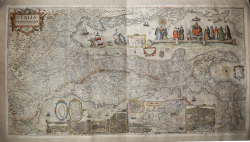
Spectacular 12-sheet map of Italy, first published by Matteo Greuter in Rome in 1630 and offered here in its second publication, by Stefano Scolari in Venice in 1657.
At the time of its publication, the map was the largest map of Italy ever published.
Another visually arresting element of the map is the depiction of Italy on its side. The map is oriented with northeast at the top. The map notes, "Questo Geografico Disegno è Voltato à traverso per la Comodità del Lettore.” In English, “This geographical design is turned sideways for the comfort of the reader...”
The map is thick with geographic content. Hundreds of villages and towns cover the interior. These are not denoted by a single symbol, but with numerous signs showing the size and type of church the locale has, the size of the settlement, and other details. Some have coats of arms included as well. Dotted lines separate political entities. Certain cities have recognizable features, including St. Peter’s Basilica and the city walls of Rome. Hills and mountains are also marked, some with unique features like a gaping hole, as it in the case of volcanic Mount Vesuvius near Naples.
The longitudes shown are relative to the Cape Verde islands and the place names are in Italian. The three major islands of Sicily, Sardinia, and Corsica are shown separately as insets. Views of major Italian cities are also shown, including Genoa, Milan, Venice, Rome, Florence, Palermo, Syracuse, Catania, Naples and Messina. There is also an inset map of Europe in the Adriatic Sea.
In the Gulf of Venice, a hand emerges from the waves to point to a scale in Venetian miles. It is protected by a Venetian vessel and menaced by a hungry sea-bear. Just below the main allegorical vignette (discussed below) is a cartouche with the twelve southern provinces of the Kingdom of Napoli. This cartouche is flanked by coats of arms. Many ships are adrift in the waters all around Italy.
In the Mediterranean, to the south of the peninsula, a cartouche houses a brief text explaining the orientation of the map. The decorative but not ostentatious strapwork on this cartouche is echoed in the title cartouche in the upper left, as well as in the inset maps and views below. There is also a compass rose with the directional winds labeled. Slightly farther east is another scale measuring twelve miles and topped with dividers.
The title cartouche contains a dedication to Signore Gioseppe Sauoldo, a judge of the College of Brescia. Brescia, a province and city in Lombardy, was then under Venetian rule. Sauoldo is also the consigliere, or advisor, to the Elector and Duke of Bavaria. In 1657, when the map was reissued, this was Ferdinand Maria, who ruled Bavaria from 1651 to 1679. Ferdinand needed the advice of men like Sauoldo, for he was only 15 when he ascended to the position of Elector. He was officially crowned in 1654 and is known for modernizing the Bavarian army and introducing the first Bavarian local governmental code.
The rich allegorical figures at the top right are yet another visual treat of this map. These center around a female representation of Italy, seated on the throne, with the Po and Tiber rivers at her feet. On either side are the trappings of civilization, including armor, a vase, an artist cherub, musical instruments, and crowns. To the left and right, Italy is flanked by five costumed ladies representing the various Italian provinces. They are opulently dressed, showing the diversity and prosperity of the Italian peninsula.
To the left of these women is Poseidon with his trident. Next to this is another allegorical figure, a regal woman draped in ermine and sumptuous clothes. She holds the scales of justice and a sword. Next to her on the decorative shell in which she floats is a lion holding a book which proclaims, “Pax Tibi Marce Evangelista Meus.” This is the symbol of the Republic of Venice, which was thriving when this map was published there. Venice took as their patron saint St. Mark the Evangelist, who is supposed to have written the gospel of Mark. The most famous church of the city is the Cathedral Basilica of St. Mark, originally the chapel of the powerful Doge, or ruler, of Venice.
St. Mark’s symbol, the lion, also represented the power of Venice as a trading state. Venetian nobility would keep lions in their gardens and there was an official state lion held captive in the Piazza San Marco. Lions were then banned after this official lion died, most likely from poison ingested by licking the gilded bars of his cage. Traditionally, and as seen on this map, the lion is shown on or near water, symbolizing Venice’s dominance of the seas and maritime commerce.
This map is known only in 2 examples, at the Biblioteca Nazionale of Florence (Fondo Palatino) and at the Bibliothèque Nationale de France (GE DD-5868).
Etching with engraving, with fine original colour (washed and refreshed) laid down on canvas, some expert repairs, generally in very good condition. VERY RARE.
Literature
A. Fappani, Enciclopedia bresciana, 2000, vol. 16, p. 348; R. Almagia, Monumenta Italae Cartographia, (Firenze, 1929), p. 64b; Roberto Borri, L’Italia nelle antiche carte dal Medioevo all’unità nazionale (2010) p. 123-129, No. 117; Valerio, "Sicily 1477 - 1861 . . .", vol. I, p. 236; Lago, Imago Italiae (2002), pp. 742-743; Ruth S. Noyes, “Mattheus Greuter’s Sunspot Etchings for Galileo Galilei’s Macchie Solari (1613)” The Art Bulletin 98, no. 4 (2016): pp. 466-487; Edward Luther Stevenson, Terrestrial and Celestial Globes: Their History and Construction (New Haven: Hispanic Society of America, 1921); Elly Decker, Globes at Greenwich (NMM, 1999).
Stefano MOZZI SCOLARI (Attivo a Venezia tra il 1644 ed il 1687)
|
Stefano “Mozzo detto Scolari” was born in the Brescia area, in Calvisano, around 1612, to Domenico Mozzi and Isabela Michel Scolari, was active in Venice between 1644 and 1687 as a printer. The scant existing bibliography identifies him as the owner of “one of the major Venetian chalcographies of the second half of the 17th century,” active in Venice from 1644 to 1687 and specializing in the reproduction of branches belonging to other publishers and printers. At a closer look, however, it becomes clear how Stefano accompanied this intense and well-known activity of reusing the copperplates of others with a commissioning and even original production of copperplates.
From 1660 onward, archival records of his presence in Venice multiply. There are two fixed points in his professional and social life: enrollment in the Scuola del Santissimo Sacramento in San Zulian, which, as we shall see, will be a source of important contacts, and in the Arte dei Pittori, obligatory in order to be able to practice the trade. He turns out to be rooted in the area adjoining the parish of San Zulian, a stone's throw from St. Mark's Square: there, in fact, are the print shop, under the sign of the “three Virtues,” the house in which he lives, and the Scuola Piccola to which he is enrolled. He is thus located in the main axis of the book trade in Venice, that area, the Mercerie, between St. Mark's Square and the Rialto Bridge, where over the centuries the stores of various publishers and booksellers have followed one another.
Stefano Mozzi Scolari was among the first to devote himself exclusively to illustrated publishing, and his activity was divided into three strands: the reprint of copperplates that had already belonged to others, especially of a geographical nature; publisher or printer of images commissioned by him, in collaboration with Giacomo Piccini and Giovanni Merlo; and printer of images he made himself. Scolari's activity, therefore, had two distinctive connotations such as the reproduction of the existing - more profitable for his print shop - and the production of images related to city life and contemporary news. His career took place in the vicinity of the parish of San Zulian, an area where it is likely that he lived as early as 1642. He was an active member of the Guild of Painters between 1660 and 1683 and an assiduous attendee of the Chapters of the School of the Blessed Sacrament in San Zulian between 1660 and 1691. An analysis of the three wills regains us much information about his family and professional acquaintances, such as the name of his wife, the Bolognese Laura Bittelli; that of his brother Giuseppe; and finally that of Daniel Baselli. The latter, who was always present throughout Scolari's professional life, is younger by about twenty-five years; for reasons that we have not been able to clarify, at his death he turns out to be in possession of branches and prints evidently coming from the Scolari inheritance, since the Scolari themselves appeal to the appropriate judiciary for an inventory to be taken.
Bibliografia
Gert Jan van der Sman. Print publishing in Venice in the second half of the Sixteenth century in Print Quarterly, XVII (2000), p. 236-247; Alessia Giachery, Stefano Mozzi Scolari «stampadore e miniatore di stampe di rame» nella Venezia del Seicento: vita, attività, eredi.
|