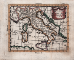
Italia Secondo i gradi dell'Accademia delle Scienze di Parigi Claude Buffier Code: S50373 Measures: 200 x 155 mm Year: 1781 Printed: Venice Price Not Available Quick view View Details
Italie Gilles Robert de VAUGONDY Code: S50386 Measures: 165 x 165 mm Year: 1750 Printed: Paris Price €125.00 Quick view View Details
Italien für die Reisende Iohann STRIDBECK Code: S50387 Measures: 310 x 170 mm Year: 1700 ca. Printed: Augsburg Price €250.00 Quick view View Details
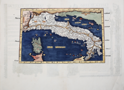
Sexta Europa Tabula Donnus Nicolaus GERMANUS Code: mms2401 Measures: 550 x 365 mm Year: 1482 ca. Printed: Ulm Price €12,000.00 Quick view View Details
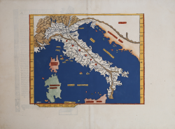
Italia Hartmann SCHEDEL Code: CO-155 Measures: 230 x 365 mm Year: 1493 Printed: Nurnberg Price €550.00 Quick view View Details
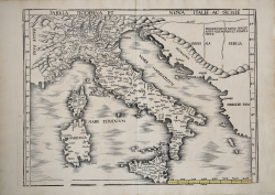
Tabula Moderna et Nova Italiae ac Siciliae Martin WALDSEEMULLER Code: IT36104 Measures: 574 x 410 mm Year: 1513 Printed: Strasbourg Price €8,500.00 Quick view View Details
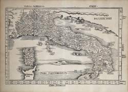
Tabula Moderna Italie Martin WALDSEEMULLER Code: S32361 Measures: 580 x 370 mm Year: 1513 Printed: Strasbourg Price €8,500.00 Quick view View Details
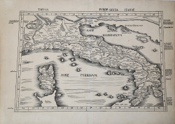
Tabula Europ. Sexta Italiae Martin WALDSEEMULLER Code: S40319 Measures: 630 x 460 mm Year: 1513 Printed: Strasbourg Price €5,500.00 Quick view View Details
Tabula Nova Italiae Laurent FRIES Code: S39273 Measures: 340 x 305 mm Year: 1522 Price €1,000.00 Quick view View Details
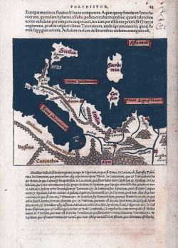
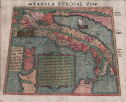
Tabula VI Europae Laurent FRIES Code: s38202 Measures: 380 x 250 mm Year: 1522 ca. Price €1,300.00 Quick view View Details
(Italia) Laurent FRIES Code: MMS1954 Measures: 340 x 265 mm Year: 1525 Printed: Lyon Price €1,300.00 Quick view View Details
Italy Sebastian Münster Code: s21275 Measures: 160 x 130 mm Year: 1538 Printed: Basle Price €500.00 Quick view View Details
Italia Sebastian Münster Code: S32641 Measures: 160 x 130 mm Year: 1538 Price €500.00 Quick view View Details
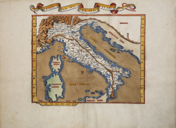
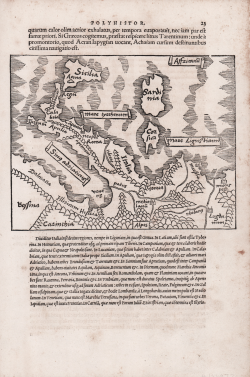
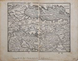
Tabula Europa VI Sebastian Münster Code: S42561 Measures: 367 x 301 mm Year: 1540 ca. Price €900.00 Quick view View Details
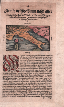
ITALIE BESCHREIBUNG NACH ALLER SEINER GELEGENHEIT, IN VOELCKERN,... Sebastian Münster Code: S24730 Measures: 165 x 295 mm Year: 1544 ca. Printed: Basle Price €225.00 Quick view View Details
(Italia) Johann STUMPF Code: s29864 Measures: 165 x 135 mm Year: 1548 ca. Printed: Zurich Price €950.00 Quick view View Details
[Das ist Rom Weg] Sebastian Münster Code: S37753 Measures: 195 x 326 mm Year: 1550 ca. Printed: Basle Price €225.00 Quick view View Details
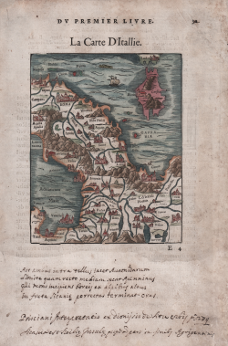
La Carte D'Itallie Guillaume GUEROULT Code: s22259 Measures: 130 x 160 mm Year: 1553 ca. Printed: Lyon Price €500.00 Quick view View Details
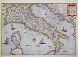
Al molto Mag.co m. Andrea Gradenico... il presente Golfo di Vinegia... Giovanni Francesco CAMOCIO Code: S30673 Measures: 225 x 175 mm Year: 1571 Printed: Venice Price €2,500.00 Quick view View Details
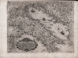
Italiae Totius Orbis olim Domatricis Nova et Exactissima Descriptio Gerard DE JODE Code: S30722 Measures: 520 x 370 mm Year: 1577 ca. Printed: Antwerpen Price €3,800.00 Quick view View Details
![[Das ist Rom Weg]](https://www.antiquarius.it/26122-home_default/italia-corsica.jpg)