| Reference: | S32085 |
| Author | Heinrich BUNTING |
| Year: | 1581 ca. |
| Zone: | St. Paul travel's |
| Printed: | Magdeburg |
| Measures: | 375 x 300 mm |
| Reference: | S32085 |
| Author | Heinrich BUNTING |
| Year: | 1581 ca. |
| Zone: | St. Paul travel's |
| Printed: | Magdeburg |
| Measures: | 375 x 300 mm |
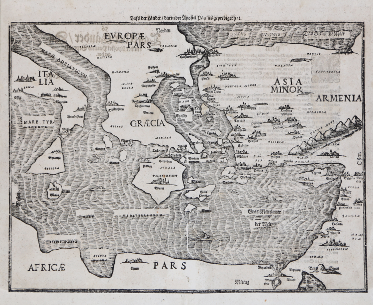
Taken from the "Itinerarium Sacrae Scripturae", the map showing the Eastern Mediterranean with Southern Italy and Sicily, Greece, Cyprus, Asia Minor, the Holy Land and North Africa, with city profiles and sea monsters.
Woodcut, very good condition.
Heinrich BUNTING (1545 - 1606)
|
Heinrich Bünting was a protestant Theologian and Chronicler. His main work "Itinerarium sacrae scripturae" first published 1581, was much valued, mainly because of its emblematic maps, which show the world arranged in the form of a clover leaf with Jerusalem at the centre, Europe in the form of a Queen and Asia in the form of Pegasus.
|