
| Reference: | s29396 |
| Author | Pierre MORTIER |
| Year: | 1704 |
| Zone: | Florence |
| Printed: | Amsterdam |
| Measures: | 610 x 510 mm |
| Reference: | s29396 |
| Author | Pierre MORTIER |
| Year: | 1704 |
| Zone: | Florence |
| Printed: | Amsterdam |
| Measures: | 610 x 510 mm |
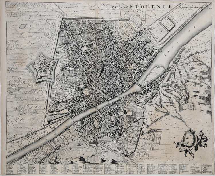
The title LA VILLE DE FLORENCE is in the upper center to the right below the frame of the engraving; in the upper right-hand corner the publisher's address A. Amsterdam Chez P. Mortier Avec Privilege; below the lower margin, arranged in nineteen columns two hundred and twenty-eight numerical toponymic references relating to the city and seventeen alphabetical ones relating to the fortress.
The plan shows the city of Florence taking the model devised by the Olivetan monk Stefano Bonsignori in 1584 filtered through the skillful revised and updated interpretation of the Bohemian Wenceslaus Hollar, a multifaceted artist of exceptional ability, printed around 1660 under the title “Florentia Pulcherrima Etruriæ civitas”, published by Johannes Janssonius in 1657. The vantage point is very high at Mount Oliveto, so that one can ideally walk through the streets of Florence in the last years of the Medici dynasty. The city is all enclosed within the walls with only a few villas or monasteries rising in the countryside; the Fortezza da Basso stands out on the left, while in the heart of the city the Duomo and Baptistery stand out, but with slightly lesser emphasis one can easily recognize Santa Croce, rather than Palazzo Vecchio or Palazzo Pitti. The right-hand corner is occupied by two putti holding the heavy Medici shield, and the lower side contains 228 references to the legend and the 17 entries relating to the pentagonal Fortezza da Basso alone.
This map was part of the first volume of Pierre Mortier's “Nouveau Theatre de l'Italie” published in Amsterdam in 1704/5 and 1724, as a supplement to Johannes Baleu's project, begun in 1663, of the great “book of cities” lacking plans of most of the northern part of the peninsula. The images of Florence and Pisa had, presumably, already been engraved by Joan Blaeu for the planned “Theater of the Grand Duchy of Tuscany” before the printing house burned down and, upon its liquidation, were purchased by Mortier, who published them in his Nouveau Theatre de l'Italie.
Blaeu, during his long publishing activity published three volumes on Italian cities. In 1663 the first three, divided into Church State, Rome and Kingdom of Naples and Sicily. Upon his death his heirs gave birth to two more volumes dated 1682 focusing on the cities of Piedmont and Savoy, later reprinted by other publishers in 1693 and 1697. The Frenchman Pierre Mortier published a reprint in 1704/5, entitled Nouveau Theatre de l'Italie. The work is in four volumes and includes Blaeu's plates, retouched and modified in small part, supplemented by the addition of several new maps of his own design, depicting the cities of the northern part of the peninsula, enclosed in the first volume of the work. Mortier's atlas was published with Latin, French and Dutch texts. The special feature that differentiates the two editions by Blaeu and Mortier is that the text is not on the verso of the individual map (which is therefore blank in the back) but is found at the beginning of each individual volume. The great success of the work gave rise to a further reprint, virtually identical, edited by R. Alberts and published in 1724/5.
Etching, in very good condition.
Bibliografia
Boffito, Mori, 1973, pp.71- 72; Cremonini pp. 83-90.
|
Pierre Mortier (January 26, 1661 - February 18, 1711) or Pieter Mortier was a cartographer, engraver, and print seller active in Amsterdam during the later 17th and early 18th centuries. Mortier, then known as Pieter, was born in Leiden. He relocated to Paris from 1681 to 1685, adopting the French name Pierre, which he retained throughout his career. While in France, he developed deep French connections by bringing sophisticated Dutch printing technology and experience to nascent French map publishers such as Guillaume De L'Isle (1675 - 1726), Alexis-Hubert Jaillot (c. 1632 - 1712), and Nicholas de Fer (1646 - 1720). Consequently, much of Mortier's business was built upon issuing embellished high quality editions of contemporary French maps - generally with the permissions of their original authors. In the greater context of global cartography, this was a significant advantage as most Dutch map publishes had, at this point, fallen into the miasma of reprinting their own outdated works. By contrast, the cartographers of France were producing the most accurate and up to date charts anywhere. Mortier's cartographic work culminated in the magnificent nautical atlas, Le Neptune Francois. He was awarded the Privilege, an early form of copyright, in 1690. Upon Pierre's death in 1711 this business was inherited by his widow. In 1721, his son Cornelius Mortier took over the day to day operation of the firm. Cornelius partnered with his brother-in-law Jean Covens to form one of history's great cartographic partnerships - Covens and Mortier - which continued to publish maps and atlases until about 1866.
|
|
Pierre Mortier (January 26, 1661 - February 18, 1711) or Pieter Mortier was a cartographer, engraver, and print seller active in Amsterdam during the later 17th and early 18th centuries. Mortier, then known as Pieter, was born in Leiden. He relocated to Paris from 1681 to 1685, adopting the French name Pierre, which he retained throughout his career. While in France, he developed deep French connections by bringing sophisticated Dutch printing technology and experience to nascent French map publishers such as Guillaume De L'Isle (1675 - 1726), Alexis-Hubert Jaillot (c. 1632 - 1712), and Nicholas de Fer (1646 - 1720). Consequently, much of Mortier's business was built upon issuing embellished high quality editions of contemporary French maps - generally with the permissions of their original authors. In the greater context of global cartography, this was a significant advantage as most Dutch map publishes had, at this point, fallen into the miasma of reprinting their own outdated works. By contrast, the cartographers of France were producing the most accurate and up to date charts anywhere. Mortier's cartographic work culminated in the magnificent nautical atlas, Le Neptune Francois. He was awarded the Privilege, an early form of copyright, in 1690. Upon Pierre's death in 1711 this business was inherited by his widow. In 1721, his son Cornelius Mortier took over the day to day operation of the firm. Cornelius partnered with his brother-in-law Jean Covens to form one of history's great cartographic partnerships - Covens and Mortier - which continued to publish maps and atlases until about 1866.
|