| Reference: | A52906 |
| Author | Giacomo GASTALDI |
| Year: | 1556 ca. |
| Zone: | Sumatra |
| Printed: | Venice |
| Measures: | 365 x 270 mm |
| Reference: | A52906 |
| Author | Giacomo GASTALDI |
| Year: | 1556 ca. |
| Zone: | Sumatra |
| Printed: | Venice |
| Measures: | 365 x 270 mm |
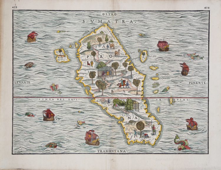
The "first separate map of any Southeast Asia island based on actual observation".
Giacomo Gastaldi's map of the Sumatra, also named Taprobana on the map, oriented with south at the top.
Published in the third volume of Giovanni Battista Ramusio's compendium of voyages, 'Delle Navigationi et Viaggi', from 1556. With printed page numbers corrected to "433" and "434" (from "430" and "434") appearing in the top left and top right-hand corners of the map, respectively.
This fine woodcut map of Sumatra (Taprobana) is the first separate map of an Indonesian island to be based on actual empirical data. It is based on the observations of the Parmentier brothers, Frenchmen who ran the Portuguese blockade of the East Indies and landed on the west Sumatran coast. Both brothers died of fever and their crew did not acquire a great deal of wealth, which dissuaded the French from sending further expeditions. Prior to Ramusio's map, Sumatra had been confused with Sri Lanka and maps of the island contained conjectural geography based primarily on Marco Polo. The map is oriented with south at the top and the shape of the island and many of its features are quite accurately portrayed. However, the nearby coastlines of Malaysia and Java are completely missing, although several of the surrounding small islands, such as Bancha (Banca) are shown. Charming scenes in the interior show vegetation, animals, and native figures at work and play, and there are numerous ships and creatures in the sea.
Ramusio's essential collection of voyages and travels is "one of the earliest and most important collections of voyages and travels of the sixteenth century" (Church). Ramusio's collection is a landmark publication for the history of exploration and travel. Ramusio, a Venetian civil servant, spent decades gathering images, accounts, and sources for his massive collection of travels and voyages. He wanted to update the geographic knowledge of antiquity, which was being challenged by European interactions with the Americas, Africa, and Asia. He especially wanted his work to be useful to mapmakers in updating their representations of the known world. The woodcut maps illustrating the work are considered to be the work of the famous Piedmontese cartographer Giacomo Gastaldi.
Woodcut with fine later hand colour, good condition.
Bibliografia
T. Suarez, Early Mapping of Southeast Asia, page 157, fig. 77.
Giacomo GASTALDI (1500 circa – 1565 circa)
|
Giacomo Gastaldi was born, according to the predicate that accompanies his signature on the card in Spain in 1544, Villafranca Piemonte (today the province of Turin), in the late fifteenth and early sixteenth century. Although counted among the greatest cartographers of the sixteenth century, the events of his life are unknown until 1539 when his name appears for the first time in a grant of privilege of printing a "perpetual almanac," now lost. In the early '40s, was to be known in learned circles because he began to work on a series of papers, first published separately and then merged, in the Italian edition of Ptolemy's Geography (Venice 1548) updated by S. Münster. The volume consisted of 60 cards, 26 of which were the traditional Ptolemaic and 34 new made by Gastaldi. Soon his fame spread as a cartographer in Italy and Europe: cosmographer became the official of the Venetian Republic. The Council of Ten, on behalf of whom had a frescoed hall of the Ducal Palace with the cards in Asia and Africa, was referring to him as: Master James of Piedmont our Cosmographer. Remains unchallenged as its contribution to the Italian maps: a map of Italy printed in 1561, when for the first time the profile of the coastline is made by referring to charts much more precise than those of previous centuries. He had the great merit of use and disclose in cartography the etching technique, which allowed all'incisore to make drawings more accurate and crisp, allowing easier viewing Almost all of them before cartographers had instead used the technique of woodcut, much less precise. He was awarded one hundred and nine maps, which represented virtually the entire world. Considering it was incorrect for a long time a mere disciple of Ramusio, and to both of you must exit from tolemaismo geography, Gastaldi was rediscovered by geography after the Italian unit. At the end of the nineteenth century p.e. Nordenskjöld placed him at the pinnacle of European maps and fifty years after the sixteenth Almagia still its greatest scholar, he rebuilt a good biography.
|