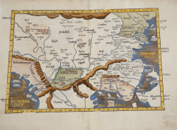
Europae Tabula Nona continet Iaziges Metanastas Daciam, Mysiam... Laurent FRIES Code: S39977 Measures: 513 x 385 mm Year: 1522 ca. Printed: Vienne Price €575.00 Quick view View Details
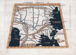
Europae Tabula IX Girolamo RUSCELLI Code: MS7996 Measures: 260 x 200 mm Year: 1561 ca. Printed: Venice Price €280.00 Quick view View Details
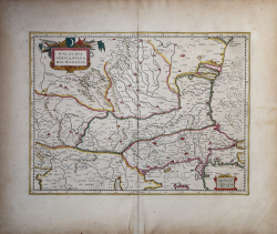
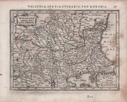
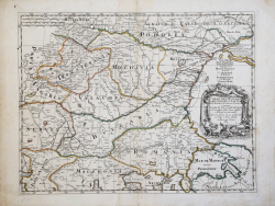
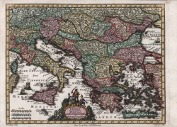
Walachia, Servia, Bulgaria, Romania Gerard MERCATOR (Kremer) Code: MMS1100 Measures: 370 x 350 mm Year: 1587 ca. Printed: Amsterdam Price €375.00 Quick view View Details
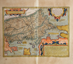
Thraciae Veteris Typus Abraham ORTELIUS Code: S46099 Measures: 470 x 350 mm Year: 1590 ca. Printed: Antwerpen Price €600.00 Quick view View Details
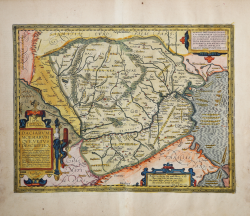
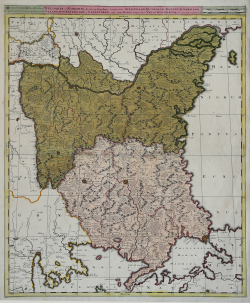
Daciarum, Moesiarumque, Vetus Descriptio. Abraham ORTELIUS Code: S46097 Measures: 468 x 365 mm Year: 1595 ca. Printed: Antwerpen Price €700.00 Quick view View Details
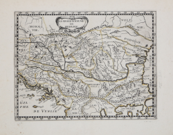
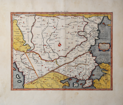
Walachia Servia, Bulgaria et Romania Johannes JANSSONIUS Code: S48240 Measures: 193 x 145 mm Year: 1628 ca. Price €125.00 Quick view View Details
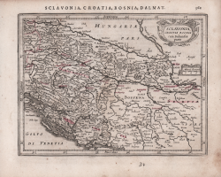
Sclavonia, Croatia Bosnia cum Dalmatiae parte Johannes JANSSONIUS Code: S48241 Measures: 192 x 145 mm Year: 1628 ca. Printed: Amsterdam Price €150.00 Quick view View Details
Le Grand Royavme de Hongrie Philippe BRIET Code: MS6788 Measures: 190 x 145 mm Year: 1653 ca. Printed: Paris Price €150.00 Quick view View Details
Exactissima Tabula qua tam Danubii Fluvii Pars Inferoir, a Belgrado... Nicolas VISSCHER I Code: S40087 Measures: 590 x 480 mm Year: 1677 ca. Printed: Amsterdam Price €325.00 Quick view View Details
Corso del Danubio da Belgrado fino al Mar Nero con le Provincie che... Giacomo CANTELLI Code: S40086 Measures: 635 x 430 mm Year: 1684 Printed: Rome Price €350.00 Quick view View Details
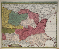
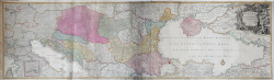
Bulgaria et Romania, divisa in singulares sangiacatus Silistriam,... Gerard & Leonard VALCK Code: S40073 Measures: 485 x 590 mm Year: 1690 ca. Printed: Amsterdam Price €400.00 Quick view View Details
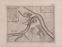
Belgrade, Ville forte, Capitale de la Rascie Nicolas DE FER Code: S49173 Measures: 285 x 225 mm Year: 1693 Price €150.00 Quick view View Details
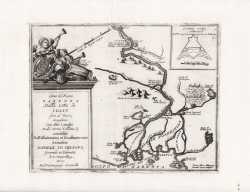
Corso del Fiume Narenta Dalla Città di Ciclut fino al Mare,... Vincenzo CORONELLI Code: MS8714 Measures: 285 x 227 mm Year: 1694 ca. Printed: Venice Price €200.00 Quick view View Details
Tab. IX Europae continens Daciam, Misiam, Thraciam ac Macedonia Gerard MERCATOR (Kremer) Code: MS4950 Measures: 460 x 360 mm Year: 1695 ca. Printed: Cologne Price €380.00 Quick view View Details
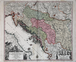
Nova et Accurata Regnorum et Provinciarum Dalmatiae, Croatiae,... Matthaus SEUTTER "il vecchio" Code: S37988 Measures: 575 x 505 mm Year: 1730 ca. Printed: Augsburg Price €375.00 Quick view View Details
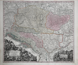
Novissima et accuratissima Hungariae... Matthaus SEUTTER "il vecchio" Code: S40032 Measures: 590 x 510 mm Year: 1730 ca. Price €300.00 Quick view View Details
Novissima Tab. Danubii et praesertim Hungaria cum aliis adjacentib... Matthaus SEUTTER "il vecchio" Code: S45904 Measures: 270 x 205 mm Year: 1744 Printed: Augsburg Price €180.00 Quick view View Details
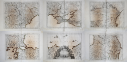
Tabula Synoptica Totius Fluminis Danubii… Tobias Conrad LOTTER Code: S9703 Measures: 1720 x 500 mm Year: 1762 ca. Printed: Ausburg Price €900.00 Quick view View Details
Carte De La Partie Septentrionale De L Empire Otoman Contentant la... Francesco & Paolo SANTINI Code: S35558 Measures: 1550 x 730 mm Year: 1777 Printed: Venice Price €900.00 Quick view View Details
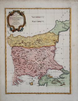
Le Provincie di Bulgaria e Rumelia… Antonio ZATTA Code: MS3984 Measures: 325 x 425 mm Year: 1781 Printed: Venice Price €130.00 Quick view View Details