
| Reference: | MS7996 |
| Author | Girolamo RUSCELLI |
| Year: | 1561 ca. |
| Zone: | Balkans |
| Printed: | Venice |
| Measures: | 260 x 200 mm |
| Reference: | MS7996 |
| Author | Girolamo RUSCELLI |
| Year: | 1561 ca. |
| Zone: | Balkans |
| Printed: | Venice |
| Measures: | 260 x 200 mm |
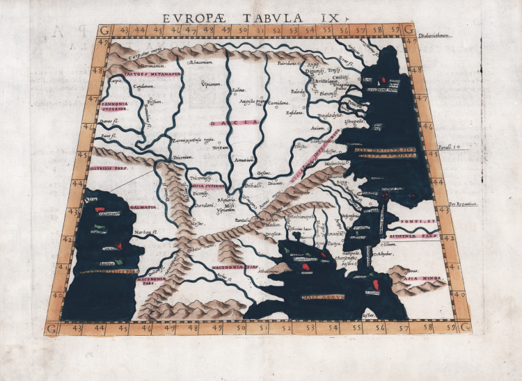
Trapezoidal map focuses on a portion of eastern Europe and the western edge of Anatolia (Asia Minor). It includes parts of Greece, Dacia, Macedonia, and the region of modern day Ukraine which is on the Black Sea. The northern boundary of the map is formed by the Carpathian Mountains. Portions of three seas are depicted, including part of the Black, the Aegean, and the Adriatic Seas.
The map names historical places such as the ancient kingdom of Bithynia, the Troas in modern day Turkey and Ilium of Homer’s epic Iliad. Modern day Istanbul is named Byzantine, perhaps a nod to legendary Byzas, who in Greek mythology is said to have been the area’s founder of the city which would become Constantinople, the eastern capitol of the Roman Empire. Familiar names dot the region on the European side of the Bosphorus as well. Mountain chains and many river systems are shown in detail.
Map taken from Geographia di Claudio Tolomeo edited by Girolamo Ruscelli, published in Venice in several editions between 1561 and 1598. The maps is based on the Geografia by Giacomo Gastaldi (1548), who probably also personally drew these maps, which were engraved by the brothers Livio and Giulio Sanuto.
The peculiarity of these maps is that they are engraved two for plate and subsequently cut; this is why the copper sign only appears on three sides of the map. Ruscelli's text and his maps are considered to be the best modern atlas up to the first version of Abraham Ortelius' Theatrum Orbis Terrarum (1570).
Only their widespread diffusion prevents a sustained evaluation in the antiquarian market. In fact, the work had a first edition in 1561, printed by Vincenzo Valgrisi who also edited the 1562 reprint. There are three editions signed by Giordano Ziletti (two in 1564 and one in 1574), while in 1597 it was published by the Calignani brothers. All these editions contain 64 plates. In 1598 and 1599 the two editions edited by Giuseppe Rosaccio and printed by the heirs of Melchior Sessa came to light. These last two editions include 69 plates; in fact, Rosaccio's map of the planisphere and continents has been added.
Etching and engraving with fine later hand colour, in good condition.
Girolamo RUSCELLI (Viterbo 1504 – Venezia 1566)
|
Girolamo Ruscelli was an Italian humanist, publisher and cartographer active in Venice in the early 16th century. Born in Viterbo, Ruscelli lived in Aquileia, Padua, Rome and Naples before moving to Venice, where he spent most of his life. Cartographically, Ruscelli is best known for his important revision of Ptolemy's Geographia, published in 1561. Based on an expansion of Giacomo Gastaldi's 1548 work Ptolemy, Ruscelli added some 37 new “Ptolemaic” maps to his Italian translation of the Geographia. Ruscelli is also listed as the editor of such important works as Boccaccio's Decameron, Petrarch's verses, Ariosto's Orlando Furioso, and various other works. In addition to his well-known cartographic work, many scholars associate Ruscelli with Alexius Pedemontanus, author of the popular De' Secreti del R. D. Alessio Piemontese. This well-known work, or “Book of Secrets,” was a collection of scientific and quasi-scientific medical recipes, household advice and technical commentary on a range of subjects that included metallurgy, alchemy, dyeing and perfume making. Ruscelli, as Alexius, founded an “Academy of Secrets,” a group of nobles and humanists dedicated to the discovery of “forbidden” scientific knowledge. This was the first known experimental scientific society and was later imitated by numerous other groups throughout Europe, including the Academy of Secrets in Naples.
|