| Reference: | S35558 |
| Author | Francesco & Paolo SANTINI |
| Year: | 1777 |
| Zone: | Black Sea |
| Printed: | Venice |
| Measures: | 1550 x 730 mm |
| Reference: | S35558 |
| Author | Francesco & Paolo SANTINI |
| Year: | 1777 |
| Zone: | Black Sea |
| Printed: | Venice |
| Measures: | 1550 x 730 mm |
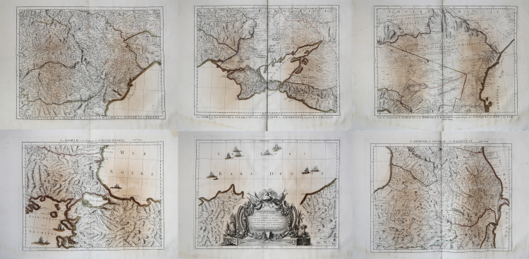
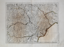
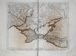
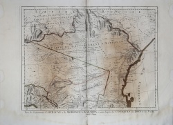
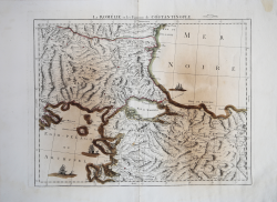
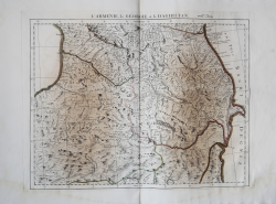
Fine example of the first state Santini's 6-sheet map of the Northern Part of the Ottoman Empire, centered on the Black Sea, published in Venice in 1779. The map was late reprinted by Giovanni Antonio Remondini.
Santini's map is based upon Giovanni Rizzi-Zannoni's map of 1774. Rizzi-Zannoni's 3 sheet map of the Northern Ottoman Empire shows the Empire at the tail end of its centuries of control of Southeastern Europe. The map extends north and east to the Caspian Sea and Cossack Regions, and west to Romania, Hungary and Bulgaria, providing a fantastic geographical and topographical depiction of the region.
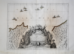
Includes a fine decorative cartouche. The 6 sheet map was bound into the Atlas Universel.
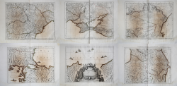
While there is some overlapping geography on the horizontal sheets, the sheets can be cut and joined to form a 6-sheet map approximately 60 inches wide and 34 inches tall.
Map compiled by Don Paolo Santini and his brother Francesco, for their prestigious Atlas universel dressé sur les meilleures cartes modernes, a sumptuous Atlas composed of maps that rework the most up-to-date French cartography in a Venetian guise.
The maps are taken from the best geographers of his time, D'Anville, Bellin, Bonne, Borgomo, Boscovich, Clarici, Delisle, Jaillot, Janvier, Robert de Vaugondy. Indeed, in Santini's maps, French terms are mixed with Italian, but they are offered with a compositional and engraving grace that is characteristic of them: an uncluttered toponymy, written large and clearly legible.
Santini's Atlas did not have great publishing success and came out in few copies: it was then reprinted by the Remondini, who had purchased the copperplates from Santini in 1781. To Paolo Santini's maps, dated between 1774 and 1780, the Remondini added several other maps, dated between 1782 and 1784: among them, in the second volume, the large folded maps of Italy, the Republic of Genoa, Palestine, and the large maps of Africa.
Paolo Santini (1729, Venice-1793, Belluno), Catholic priest at the Church of Santa Maria Formosa in Venice, professor of drawing at schools in the Lagooon city of the Venetian Province of the Society of Jesus. Santini, a cartographer, engraver and publisher, updated and published the maps of French geographers and cartographers Gilles Robert de Vaugondy (1688-1766) and Didier Robert de Vaugondy (c. 1723-1786), also drawing inspiration from the works of Italian cartographers, first and foremost those of Giovanni Antonio Rizzi Zannoni (1736-1814). Using, as a model, the maps collected and published in 1752 in the Atlas Universel by Gilles Robert and Didier Robert de Vaugondy, purchased in Paris by his brother, Francesco Santini, and the "best maps" of the time, Paolo Santini engraved new plates and gave to the presses in Venice, in 1776, the Atlas Universel dressé sur les meilleures cartes modernes. The following year, 1777, he sold the publishing rights to publisher Giuseppe Remondini (1754-1811) of Bassano del Grappa, who reprinted the "Atlas Universel" in two volumes that collected a total of 123 maps. The copper plates in the Santini's possession were later purchased, in 1781, by the Remondini printing house.
Copperplate engraving, original outline coloring, diffuse uniform burnishing, otherwise in excellent condition.
Bibliografia
NMM III, 277; Nordenskiöld 276; Phillips, Atlases 647. Rodolfo Gallo, L'incisione nel '700 a Venezia e a Bassano, in “Ateneo Veneto”, A. CXXXII, v. 128, pp. 153-214.
Francesco & Paolo SANTINI (Attivi a Venezia seconda metà del XVIII secolo)
|
Paolo Santini (1729 Venice - Belluno 1793) was a priest of the church of Santa Maria Formosa in Venice, and professor of drawing at the public schools of the Jesuits. From the best papers of the time he realized his brother Francis, the famous Atlas Universal, split into two volumes and containing 123 cards. Francesco Santini he published between 1776 and 1780. Then the branches of the intaglio print cards were purchased in 1781 by Bassano Printing Remondini which reissued the atlas.
|