
| Reference: | s25113 |
| Author | Pierre MORTIER |
| Year: | 1704 ca. |
| Zone: | Central Italy |
| Printed: | Amsterdam |
| Measures: | 450 x 600 mm |
| Reference: | s25113 |
| Author | Pierre MORTIER |
| Year: | 1704 ca. |
| Zone: | Central Italy |
| Printed: | Amsterdam |
| Measures: | 450 x 600 mm |
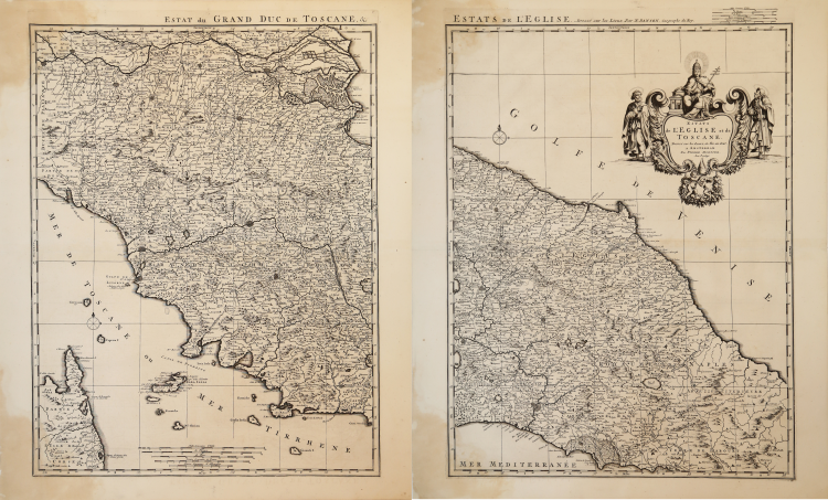
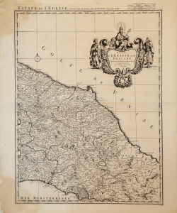
Grande carta dello Stato della Chiesa con la Toscana, in due fogli ancora da unire, pubblicata da Pierre Mortier nel Nouveau Théâtre d'Italie... stampato ad Amsterdam nel 1704-1705, e successivamente nel 1724 dall'editore R. C. Alberts.
Successivamnete la carta venne ristampata da Johannes Covens e Cornelis Mortier nell'Atlas nouveau, contenant toutes les parties su Monde, ou sont exactement remarquees les empires, monarchies, royaumes, etats, republiques, &c. Par Guillaume de l'Isle. Premier Geographe de sa Majeste. Ad Amsterdam, Chez Jean Covens & Corneille Mortier, sur le Vygendamm, circa 1740.
“Graduata ai margini di 5' in 5', va da 41° 20' a 44° 50' lat. e da 35° 30' a 39° 02' long. È orientata sui quattro lati, all'interno della cornice. Le scale, disegnate in alto fuori dal quadro, sono di cinque tipi (in miglia comuni d'Italia, Firenze, Roma, Francia e Germania). Deriva dalla carta di Nicolas Sanson, pubblicata nel 1647. [..] Pare emergere, quale prima preoccupazione, quella di riportare il più alto numero di toponimi di centri abitati, per i quali vengono sacrificati quelli dei corsi d'acqua minori pur mantenendone il disegno del reticolo. Di facile lettura sono i confini politici, disegnati con una linea tratteggiata e più marcata. Il pregio maggiore della tavola sta tuttavia nel raffigurare la rete viaria con le località più importanti lungo i percorsi (per il territorio che ci riguarda si notino la Via Flaminia, che da Narni porta a Terni- Strettura-Spoleto-Foligno, e la strada Foligno-Perugia). La scritta Ombrie è fatta sinonimo di Duché de Spolète, escludendone come sempre il territorio di Perugia” (cfr. "Le antiche terre del Ducato di Spoleto", p. 132).
Incisione in rame, due fogli separati, con margini, leggera brunitura nei margini inferiori, per il resto in buono stato di conservazione.
|
F. Ronca - A. Sorbini (a cura di), Le antiche terre del Ducato di Spoleto. I territori di Spoleto e Terni nella cartografia dei secoli XVI-XIX, 2005, pp. 132-133, n. 52.
|
|
Pierre Mortier (January 26, 1661 - February 18, 1711) or Pieter Mortier was a cartographer, engraver, and print seller active in Amsterdam during the later 17th and early 18th centuries. Mortier, then known as Pieter, was born in Leiden. He relocated to Paris from 1681 to 1685, adopting the French name Pierre, which he retained throughout his career. While in France, he developed deep French connections by bringing sophisticated Dutch printing technology and experience to nascent French map publishers such as Guillaume De L'Isle (1675 - 1726), Alexis-Hubert Jaillot (c. 1632 - 1712), and Nicholas de Fer (1646 - 1720). Consequently, much of Mortier's business was built upon issuing embellished high quality editions of contemporary French maps - generally with the permissions of their original authors. In the greater context of global cartography, this was a significant advantage as most Dutch map publishes had, at this point, fallen into the miasma of reprinting their own outdated works. By contrast, the cartographers of France were producing the most accurate and up to date charts anywhere. Mortier's cartographic work culminated in the magnificent nautical atlas, Le Neptune Francois. He was awarded the Privilege, an early form of copyright, in 1690. Upon Pierre's death in 1711 this business was inherited by his widow. In 1721, his son Cornelius Mortier took over the day to day operation of the firm. Cornelius partnered with his brother-in-law Jean Covens to form one of history's great cartographic partnerships - Covens and Mortier - which continued to publish maps and atlases until about 1866.
|
|
F. Ronca - A. Sorbini (a cura di), Le antiche terre del Ducato di Spoleto. I territori di Spoleto e Terni nella cartografia dei secoli XVI-XIX, 2005, pp. 132-133, n. 52.
|
|
Pierre Mortier (January 26, 1661 - February 18, 1711) or Pieter Mortier was a cartographer, engraver, and print seller active in Amsterdam during the later 17th and early 18th centuries. Mortier, then known as Pieter, was born in Leiden. He relocated to Paris from 1681 to 1685, adopting the French name Pierre, which he retained throughout his career. While in France, he developed deep French connections by bringing sophisticated Dutch printing technology and experience to nascent French map publishers such as Guillaume De L'Isle (1675 - 1726), Alexis-Hubert Jaillot (c. 1632 - 1712), and Nicholas de Fer (1646 - 1720). Consequently, much of Mortier's business was built upon issuing embellished high quality editions of contemporary French maps - generally with the permissions of their original authors. In the greater context of global cartography, this was a significant advantage as most Dutch map publishes had, at this point, fallen into the miasma of reprinting their own outdated works. By contrast, the cartographers of France were producing the most accurate and up to date charts anywhere. Mortier's cartographic work culminated in the magnificent nautical atlas, Le Neptune Francois. He was awarded the Privilege, an early form of copyright, in 1690. Upon Pierre's death in 1711 this business was inherited by his widow. In 1721, his son Cornelius Mortier took over the day to day operation of the firm. Cornelius partnered with his brother-in-law Jean Covens to form one of history's great cartographic partnerships - Covens and Mortier - which continued to publish maps and atlases until about 1866.
|