| Reference: | S27086 |
| Author | Paolo FORLANI |
| Year: | 1564 |
| Zone: | Cuba & Hispaniola |
| Printed: | Venice |
| Measures: | 188 x 258 mm |
| Reference: | S27086 |
| Author | Paolo FORLANI |
| Year: | 1564 |
| Zone: | Cuba & Hispaniola |
| Printed: | Venice |
| Measures: | 188 x 258 mm |
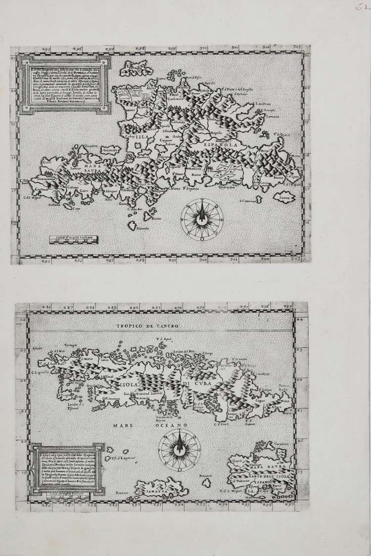
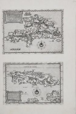
Pair of maps depicting the island of Cuba and that of Hispaniola, printed on a single sheet of sixteenth-century paper. Examples in the first state of two, before the address of Pietro de Nobili, described in Bifolco/Ronca.
The cartouche at the top left of the map of Hispaniola, at the top of the sheet, reads: L’Isola Spagnola una delle prime che Colombo trovasse, hoggi e detta L’Isola di .S. Dominico, el’habitano Spagnoli, per cio che pochi Isolani vi sono rimasi. E fertilissima di molte cose, come di Cottone, Mastice, Aloe, Cannella, Zenzero, et altre Speciarie, Quivi non nascevano animali di quatro piedi fuor che Conigli, ma ora vi nascono Cavalli bonissimi, et Buoi, et altre sorte simili. E isola molto grande et di aere perfetto, et hoggi fertile di tutte le cose, la sua figura e come si vede, con una scala di miglia Italiani. jn venetia l’anno 1564. Paulo Forlano Veronese .f.
This map by Paolo Forlani is based on the Gastaldi model; the first map of any importance of the island is the one included in the Summario de la generale historia de l’Indie Occidentali cauato da libri scritti dal Signor Don Pietro Martyre ... et da molti altre particolari relationi, a triptych of travel reports, translated from Spanish and edited by Giovanni Battista Ramusio, published in Venice by A. Pinto in 1534. In the third part, a translation of the text La conquista del Peru published in Siviglia in 1534, and an attached woodcut map entitled ISOLA SPAGNUOLA. Giacomo Gastaldi based his map of the island, published in the Geografia of 1548, on this map; a model later re-proposed by Girolamo Ruscelli in 1561. Forlani's map is almost always found in collections together with the map of Cuba. Karrow also attributes this plate to Giacomo Gastaldi. The map was subsequently reprinted in Rome, by the publisher Pietro de Nobili. It is assumed that the copper was acquired by Claudio Duchetti and then introduced into the Roman chalcographic market. It is listed in the catalog of the Antonio Lafreri printing house of about 1573 (no. 76), as “Cuba et Spagnola Isole”. The copperplate was inherited by Stefano Duchetti and sold to Paolo Graziani (1581) and then to Pietro de Nobili. The map is present in the catalog of de Nobili (inv. May 1586, no. 149), as “L’Isola di s. Domenico”.
In the cartouche at the bottom left of the map of Cuba, at the bottom of the sheet, we read: L’Isola Cuba e piu sette[n]tio[n]al della Spagnola et e a[n]cor essa molto abo[n]da[n]te di zuccaro, Cottone, Oro, et altre cose simili, insieme co[n] molte Speciarie, Produce molto forme[n]to indiano detto da paesani Maiz, jl Populo di q[ue]sta jsola e molto piu humano et piacevole, di quello della Spagnola. Hanno copia de Betume, opegola la quale nasce d’una fo[n]te naturalme[n]te. Quivi e aere molto te[m]p[er]ato et buono. Et e situata, et figurata come si vede.
La carta di Cuba di Paolo Forlani, sebbene non datata, può essere sicuramente fatta risalire al 1564 in quanto stampata in coppia con la carta di Hispaniola, che reca appunto quella data. Come per la carta di Hispaniola Forlani si ispira alle opere di Giacomo Gastaldi inserite nelle edizioni veneziane della Geografia di Tolomeo (1548 e 1561). Karrow attribuisce anche questa carta a Giacomo Gastaldi.
La fonte cartografica di queste due mappe e tuttora sconosciuta; se l’orografia, l’idrografia e i toponimi delle mappe derivano dalle precedenti, la morfologia delle isole e assolutamente differente e risulta molto distorta. La lastra ebbe una successiva tiratura postuma, stampata a Roma dall’ editore Pietro de Nobili. Si ipotizza che il rame venne acquisito da Claudio Duchetti e quindi introdotto nel mercato romano. La si trova elencata nel catalogo della tipografia di Antonio Lafreri del 1573 circa (n. 76), come “Cuba et Spagnola Isole”. La matrice venne ereditata da Stefano Duchetti e ceduta a Paolo Graziani (1581) e quindi a Pietro de Nobili. La carta e presente nel catalogo della tipografia (inv. maggio 1586, n. 150), come “L’Isola di Cuba spagnolo”.
Paolo Forlani's map of Cuba, although undated, can certainly be traced back to 1564 as it was printed as a pair with the map of Hispaniola, which bears that date. As with the map of Hispaniola, Forlani was inspired by the works of Giacomo Gastaldi included in the Venetian editions of Ptolemy's Geography (1548 and 1561). Karrow also attributes this map to Giacomo Gastaldi.
The cartographic source of these two maps is still unknown; if the orography, hydrography and toponyms of the maps derive from the previous ones, the morphology of the islands is absolutely different and is very distorted. The plate had a subsequent posthumous issue, printed in Rome by the publisher Pietro de Nobili. It is assumed that the copperplate was acquired by Claudio Duchetti and then introduced into the Roman market. It is listed in the catalogue of the Antonio Lafreri printing house from around 1573 (n. 76), as “Cuba et Spagnola Isole”. The matrix was inherited by Stefano Duchetti and sold to Paolo Graziani (1581) and then to Pietro de Nobili. The paper is present in the catalogue of the printing house (inv. May 1586, n. 150), as “L’Isola di Cuba spagnolo”.
Paolo Forlani, a native of Verona, opened his own chalcographic workshop in Venice, Al segno del pozzo, in 1560, as reflected in some of his works. From 1566 he was active in Merzaria al segno della colonna and from 1569 in Merzaria al segno della nave. Forlani had business relationships with the major publishers of cartographic material of the time, among them Antonio Lafreri, the Bertelli family, and others. In addition to being a talented engraver, he was also quick to execute, a quality that enabled him to work for different publishers at the same time, and to execute a large amount of work. Woodward attributes about one hundred works to Forlani, most of which, however, are unsigned. Between 1560 and 1567, Forlani collaborated with Ferrando Bertelli, for whom he engraved about ten copperplates, with Camocio, Bolognino Zaltieri, and with Claudio Duchetti, for whom he engraved some maps. For his professional activity, however, the collaboration with Giacomo Gastaldi, for whom he engraved thirteen maps, was very important and valuable. In 1567 Forlani published and traded his work Il primo libro delle città et fortezze principali del mondo, whose branches later passed to Bolognino Zaltieri. It is likely that Forlani died during the plague that spread through Venice from 1575.
Etching and engraving, magnificent proofs printed on a single sheet of contemporary laid paper with “lamb in a circle” watermark, with wide margins, in excellent condition. Size: mm 175x240 (Cuba) e mm 188x258 (Hispaniola).
Bibliografia
for Hispaniola: Bifolco-Ronca, Cartografia e Topografia Italiana del XVI secolo, p. 366, tav. 63, I/II; Alberti (2009): p. 127, n. A.73; Karrow (1993): n. 30/62.2; Pagani (2008): p. 383; Tooley (1939): n. 84 & n. 85; Woodward (1990): n. 30; Woodward (1992): n. 30.
for Cuba: Bifolco-Ronca, Cartografia e Topografia Italiana del XVI secolo, p. 362, tav. 60, I/II; Alberti (2009): p. 127, n. A.72; Karrow (1993): n. 30/61.1; Pagani (2008): p. 383; Tooley (1939): n. 90 & n. 91; Woodward (1990): n. 29.01; Woodward (1992): n. 64.
Paolo FORLANI (Attivo a Venezia seconda metà del XVI secolo)
|
Paolo Forlani, a native of Verona, opened his own chalcographic workshop in Venice, Al segno del pozzo, in 1560, as reflected in some of his works. From 1566 he was active in Merzaria al segno della colonna and from 1569 in Merzaria al segno della nave. Forlani had business relationships with the major publishers of cartographic material of the time, among them Antonio Lafreri, the Bertelli family, and others. In addition to being a talented engraver, he was also quick to execute, a quality that enabled him to work for different publishers at the same time, and to execute a large amount of work. Woodward attributes about one hundred works to Forlani, most of which, however, are unsigned. Between 1560 and 1567, Forlani collaborated with Ferrando Bertelli, for whom he engraved about ten copperplates, with Camocio, Bolognino Zaltieri, and with Claudio Duchetti, for whom he engraved some maps. For his professional activity, however, the collaboration with Giacomo Gastaldi, for whom he engraved thirteen maps, was very important and valuable. In 1567 Forlani published and traded his work Il primo libro delle città et fortezze principali del mondo, whose branches later passed to Bolognino Zaltieri. It is likely that Forlani died during the plague that spread through Venice from 1575.
|