
| Reference: | S37998 |
| Author | Georg BRAUN & Franz HOGENBERG |
| Year: | 1581 |
| Zone: | Pozzuoli |
| Printed: | Antwerpen & Cologne |
| Measures: | 530 x 400 mm |
| Reference: | S37998 |
| Author | Georg BRAUN & Franz HOGENBERG |
| Year: | 1581 |
| Zone: | Pozzuoli |
| Printed: | Antwerpen & Cologne |
| Measures: | 530 x 400 mm |
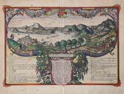
A fascinating view of Pozzuoli and the Gulf of Baia with Ischia, in the background within a very rich ornamental motif with cornucopias, fruit, cherubs, flowers and ribbons.
On the left and on the right, at the bottom, a legend lists of the most significant places.
"Their travels led Georg Hoefnagel and his companion Ortelius (left, on a knoll) to the Gulf of Baia. Complementing the two engravings in volume II, this view is seen from an elevated point in the east and shows Pozzuoli in the foreground (T) together with the islands of Procida (C) and Ischia (D), the castle of Baia (F-G), the mountain with the Grotto of the Camaean Sybil (O), Lake Averno (P) and the temple of Jupiter (Y), flanked by curving cornucopias overflowing with the abundant gifts of nature in this climatically blessed region. The accompanying texts draw upon a knowledge of the literature of classical antiquity, for instance the remark that Cape Misenum (B) is named after Misenus, Aeneas's trumpeter, who is buried there, or the reference to natural histories, such as that of the Trituli sweat baths (L). This plate is unique in the city atlas because of its colourfulness. At the same time it is an important example of creative talents of the artist, Hoefnagel, who, in collaboration with his travelling companion Ortelius, who is again lavishly praised in the inset text (centre), augments his observations of nature with his knowledge of the classics and natural history". (Taschen)
The work is included in the Civitates Orbis Terrarum, the first atlas devoted exclusively to plans and views of the world's major cities. Printed in six volumes between 1572 and 1617 it was so successful and widespread that several editions translated into Latin, German and French were printed.
The first volume of the Civitates Orbis Terrarum was published in Cologne in 1572. The sixth and the final volume appeared in 1617. This great city atlas, edited by Georg Braun and largely engraved by Franz Hogenberg, eventually contained 546 prospects, bird-eye views and map views of cities from all over the world. Fransz Hogenberg produced the plates for the first four books, and Simon van den Neuwel (Novellanus, active since 1580) those for volumes V and VI.
Georg Braun (1541-1622), a cleric of Cologne, was the principal editor of the work, and was greatly assisted in his project by the close, and continued interest of Abraham Ortelius, whose Theatrum Orbis Terrarum of 1570 was, as a systematic and comprehensive collection of maps of uniform style, the first true atlas. The Civitates, indeed, was intended as a companion for the Theatrum, as indicated by the similarity in the titles and by contemporary references regarding the complementary nature of two works. Nevertheless, the Civitates was designs to be more popular in approach, no doubt because the novelty of a collection of city plans and views represented a more hazardous commercial undertaking than a world atlas, for which there had been a number of successful precedents. Franz Hogenberg (1535-1590) was the son of a Munich engraves who settled in Malines. He engraved most of the plates for Ortelius's Theatrum and the majority of those in the Civitates, and may have been responsible for originating the project.
Over a hundred of different artists and cartographers, the most significant of whom was Antwerp artist Georg Hoefnagel (1542-1600), engraved the cooper-plates of the Civitates from drawings. He not only contributed most of the original material for the Spanish and Italian towns but also reworked and modified those of other contributors. After Hoefnagel's death his son Jakob continued the work for the Civitates.
The author set out to depict "non icones et typi urbium," that is, not generic and typified images, "sed urbes ipsae admirabili caelaturae artificio, spectantium oculis subiectae appareant": not intended to allude or idealize but to represent faithfully on paper, to reproduce exactly, and in real time, what the eye sees, as announced in the preface to the first volume of Civitates Orbis Terrarum., perfect condition.
|
Van der Krogt 4, #3459; Fauser, #11185; Taschen, Br. Hog., p.265.
|
|
George Braun (1541-1622), cleric of Cologne, was the principal editor of the Civitates Orbis Terrarum, and was greatly assisted in his project by the close, and continued interest of Abraham Ortelius, whose Theatrum Orbis Terrarum of 1570 was, as a systematic and comprehensive collection of maps of uniform style, the first true atlas.
Franz Hogenberg (1535-1590) was the son of a Munich engraves who settled in Malines. He engraved most of the plates for Ortelius's Theatrum and the majority of those in the Civitates, and may have been responsible for originating the project.
|
|
Van der Krogt 4, #3459; Fauser, #11185; Taschen, Br. Hog., p.265.
|
|
George Braun (1541-1622), cleric of Cologne, was the principal editor of the Civitates Orbis Terrarum, and was greatly assisted in his project by the close, and continued interest of Abraham Ortelius, whose Theatrum Orbis Terrarum of 1570 was, as a systematic and comprehensive collection of maps of uniform style, the first true atlas.
Franz Hogenberg (1535-1590) was the son of a Munich engraves who settled in Malines. He engraved most of the plates for Ortelius's Theatrum and the majority of those in the Civitates, and may have been responsible for originating the project.
|