
| Reference: | S40150 |
| Author | Mario CARTARO |
| Year: | 1584 |
| Zone: | Campi Flegrei |
| Printed: | Rome |
| Measures: | 570 x 430 mm |
| Reference: | S40150 |
| Author | Mario CARTARO |
| Year: | 1584 |
| Zone: | Campi Flegrei |
| Printed: | Rome |
| Measures: | 570 x 430 mm |
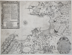
THE FIRST ACCURATE REPRESENTATION OF THE PHLEGRAEAN FIELDS
In the lower cartouche: ILLUSTRISS. Atque excellentiss. Principi Petro Giron Duci de Ossuna, Comiti de Vrena et, Proregi Neapoletano domino suo colendissimo Bartolomoeus Grassus Typographus Romanus S. P. D. Marius Cartharius, Maxime Princeps, Romanus civis atque de politioribus disciplinis benemeritus, cum superioribus diebus ageret Neapoli, id suae dilige[n]tiae industrioeque esse censuit si Puteolos veniens, quae ibi venerandae antiquitatis monimenta extant, curiose inquireret, observaret, delinearet, exprimeret. Urbem reversus, non ingratam Studiosis omnibus opera[m] se posuisse comperit. Nam cum antiquis recentibusque, bellor[um] direptionibus quassata toties misera[m] Italia[m] nostra[m], nullum fere sacrosanttae vetustatis xemplum habeamus sed ricinosa ta[n]tum quaedam rudera, lacera fragm.ta dirutas materias: in una illa Felicis Campaniae parte, nescio quo serva[n]te syncera integraque plurima conserva[n]tur. Addes, Princeps Generose, innumera illa quae illie visuntur Naturae miracula, exteris certe[m] hominibus porte[n]to sano stratibus etia[m] admira[n]da Ego igitur, (qui studia bonar[um] artium amo, et illaru[m] ama[n]tes ut iuve[m], quod possum continuo proesto) co[n]gita Cartharij dilige[n]tia, opere pretiu[m]duxi, si quaprimu[m] aeneis formis incisa in publicu[m] prodiret Sed nec hoc co[n]tentus novam Puteolis nostris illustratione[m] apparavi, relictis enim illis omnibus, in quibus sub hoc tempus typographica officina nostra desudabta, doctissimor[um] hominu[m] notas, quae veram Puteolanae antiquitatis ratione[m] edoreant, praelis commisi. Utrumque Princeps Illustrissime, tuo felicissimo nomini Sacrum esse patere, Hoc ut me, homine ignotum ad tantam celsituadinem in viam deducat, illud, ut in eiusdem perpetua[m] clientelam ac fide[m] conferat Vale Dux excele[n]tissime Romae IV Non Octob. M.D.LXXXIIII.
In the upper cartouche: EXPLICATIO ALIQUOT LOCORUM QUAE PUTEOLIS SPECTANTUR. This is followed by a numerical legend of 20 references to notable places. The cartouche also reads: IULII ROSCII HORTINI DE rebus mirabilibus Puteolorum EPIGRAMMA Hic vires natura suas expressit, et auxit Ars opus. Eximius certat utrinque labor. Illa homines miserata cavis et rupibus undam Elicit, optatam qua trahat aeger opem. Ars veterum monimenta Virum, stagna, antra, lacusque, Ambarum claro tollit se gloria coelo. Quid magis obstupeat nescius hospes abit. Gloria sed maior surgit tibi candida Syren, quae gremio servas commoda tanta tuo. Orientation provided by a wind rose in the sea, northeast at the bottom. Graphic scale of 100 miles equal to 108 mm. Work without graduation.
Etching and engraving, dimensions mm 430x570.
"The map published by Bartolomeo Grassi and engraved by Mario Cartaro represents the direct prototype of almost all the cartographies of the Phlegrean Fields until the middle of the 18th century, when, due to renewed archaeological interests, those places were revisited with greater attention by carrying out surveys with new instruments.
It is the first archaeological map of the Phlegrean Fields, very rich in antiquarian information and very useful for the location of the main monuments of the area, both of those still existing and of the disappeared antiquities, whose location is based on literary sources. The dedication of the work is dated October 4, 1584. Grassi obtained the privilege for the printing on October 1 of the same year, together with the privilege for a book on the antiquities of Pozzuoli, illustrated by plates engraved by Cartaro" (see S. Bifolco, F. Ronca, Cartografia e topografia italiana del XVI secolo, 2018: pp: pp. 2068-2069, Tav. 1045).
On the area of the Phlegraean Fields previously (1538) had been printed the famous IL VERO DISEGNIO IN SUL PROPIO LUOGHO RITRATTO DEL INFELICE PAESE DI POSUOLO, by the Maestro del Trabocchetto (B/R. Tav. 1044), a broadsheet map to document the earthquake that had given light to Monte Nuovo, which however did not delineate the area so accurately.
The map by Grassi/Cartaro is extremely rare and only two specimens are known in public collections: Chicago, Newberry Library; Paris, Bibliothèque Nationale.
Bartolomeo Grassi (active in Rome between 1582 and 1600) was probably born in Rome, where he lived and worked in the last twenty years of the sixteenth century. He lived in Via del Pellegrino, where his typographic workshop was also located. Bartolomeo had begun his apprenticeship as a typographer in the workshop of Giorgio Ferrari, before embarking on an independent activity, during which he printed more than forty editions, some of which of particular value. His most productive years are those between 1585 and 1587, just in 1585 from his workshop comes out a valuable edition: the collection of plates of Giovanni Battista Cavalieri Ecclesiae militantis triumpi. For many of his works he availed himself of the collaboration of other typographers. The typographical mark of Grassi is a comet star above a double-headed eagle and three lilies. There are no more news after 1600.
Mario Cartaro (active in Rome between 1560 and 1580, then in Naples until 1620) was an engraver, draftsman, cartographer and merchant from Viterbo, although for a long time he was considered of Nordic origin because in addition to "Cartarus" and "Cartarius" he also signed "Kartarus" and "Kartarius", and used indifferently the initials "MC" and "MK". The origin is declared by himself in the map of Rome Celeberrimae urbis antiquae fedelissima topographia of 1579, in which he signs Marius Kartarius Viterbensis. Kartarius was active in Rome in 1560 where his editor of reference was Antonio Lafreri, who included some of his engravings in the collections Speculum Romanae Magnificentiae and Tavole Moderne di Geografia. He engraved mainly by burin, more rarely used the etching. His activity began with the realization of copies from various authors including Giorgio Ghisi, Cornelis Cort, Albrecht Dürer and Marcantonio Raimondi. He also engraved a series of twenty-six prints without frontispiece of views, ruins and bridges of Rome, the Corografia delle Terme di Diocleziano and Prospettive diversi in 1578. Between 1562 and 1588, Cartaro engraved maps and city plans. A few years later he moved to Naples where, in 1586, he was commissioned together with Nicola Antonio Stigliola to compile an atlas of the entire Kingdom. His name appears among the Engineers of the Royal Court until 1610. He lived in Naples until his death on April 16, 1620.
Magnificent example.
Bibliografia
S. Bifolco, F. Ronca, Cartografia e topografia italiana del XVI secolo, 2018: pp. 2068-2069, Tav. 1045; Almagià (1913): pp. 104-106; Almagià (1929): p. 47, B; Bifolco-Ronca (2014): n. 129; cfr. Mezzetti (1972): vol. I, tav. 5; Tooley (1983): n. 459a; Witcombe (2008): p. 350, n. 266.
|
Engraver, print dealer and publisher, from Viterbo. Active in Rome c.1557-86/8; in Naples by 1588.First dated work 1560.He engraved and published his own work and also acquired plates from others.
The Museum of the History of Science in Florence has a printed celestial globe signed by him, 1577. There is a matching terrestrial globe in the Monte Mario Observatory .His productin seems to have concentrated on devotional subjects and maps.Large maps of Rome 1576.He took on commissions for copperplates from Ferrando Bertelli in Venice:three maps of 1562-3.Plates in Vaccari stocklist of 1614.
|
|
Engraver, print dealer and publisher, from Viterbo. Active in Rome c.1557-86/8; in Naples by 1588.First dated work 1560.He engraved and published his own work and also acquired plates from others.
The Museum of the History of Science in Florence has a printed celestial globe signed by him, 1577. There is a matching terrestrial globe in the Monte Mario Observatory .His productin seems to have concentrated on devotional subjects and maps.Large maps of Rome 1576.He took on commissions for copperplates from Ferrando Bertelli in Venice:three maps of 1562-3.Plates in Vaccari stocklist of 1614.
|