| Reference: | S40328 |
| Author | Paolo PETRINI |
| Year: | 1700 ca. |
| Zone: | Celestial Chart |
| Printed: | Naples |
| Measures: | 560 x 400 mm |
| Reference: | S40328 |
| Author | Paolo PETRINI |
| Year: | 1700 ca. |
| Zone: | Celestial Chart |
| Printed: | Naples |
| Measures: | 560 x 400 mm |
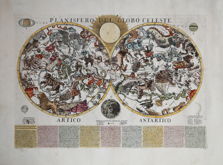
Very rare copy of the Celestial Globe by Francesco Brunacci (Rome 1687) printed in Naples by Paolo Petrini's typography, early '700.
Although undated and without printing details, the plate - for stylistic and typographical reasons and for the type of paper on which it is printed - can be attributed to Paolo Petrini.
The map is part of the Atlante Partenopeo, a complex publishing operation carried out by the Neapolitan bookseller and typographer Petrini to collect many of the maps made by him since the last decade of the seventeenth century, drawn substantially from Guillaulme Sanson, Nicolas De Fer and Giacomo Cantelli, and published with updates also for most of the eighteenth century by his son Nicola.
Petrini's atlas represented for the Kingdom of Naples, the equivalent of the Mercurio Geografico printed in Rome by the De Rossi printing house, and circulating mainly in the Papal States.
The original Brunacci's work is part of the Mercurio Geografico.
Francesco Brunacci was born in Monte Novo on September 19, 1640. Conducted the very first studies in his native country, he continued them from 1657 to 1662 in Macerata, graduating in civil and canon law. Moved to Rome, he practiced the legal profession until he obtained the position of Consultant of Rites, having been chosen, previously, several times to settle disputes among the most important personalities of the time. He was auditor of several high prelates and appreciated above all by Cardinal Vettori for his legal, philosophical and mathematical knowledge.
In this astronomical chart Brunacci presents us the 67 constellations in use in his time: the 48 Ptolemaic, the new 12 constellations of the southern hemisphere introduced by Keyser and Houtman, Ganymede, Chioma di Berenice, Pardocamelo, Fiume Giordano, Alicorno, Columba di Noe and the Cruise. In the Antarctic polar circle he draws the Minor Cloud and the Major Cloud. Among the brightest stars it indicates the name of the Goat and the Ear of the Virgin. The stars are divided by magnitude into six classes.
The map is accompanied by an explanatory text where the author declares to have followed Bayer's work, the Uranometria of 1603, both for the technical-scientific contents and for the style of representation of the constellations.
The Arctic and Antarctic Planisphere are represented in convex ecliptic polar stereographic projection. The grid centered on the ecliptic pole allows us to read the longitude of the stars with the precision of one degree, every thirty we find a line of longitude, the latitude circles are missing. The polar circles, those of the tropics, the colurs and the equinoctial circle are instead highlighted. The two planispheres are joined by the solstice colur in the constellation Sagittarius.
Copper engraving, contemporary coloring with later addition, in excellent condition. Very rare.
Paolo PETRINI (Attivo a Napoli fine del XVIII secolo)
|
very little is known about Petrini except that for many years he was a publisher and map seller in Naples producine large and small maps often slavishly based on those by Guillaume Sanson and Nicolas de Fer. About 1718 he published a large-scale plan of Naples. All his work is very rare.
1700 Atlante Partenopea
1700 Mappa Mondo Vero Carta
1700 ca. Maps of the wolrd and continents (wall maps)
|