

| Reference: | S39505 |
| Author | Reiner & Joshua OTTENS |
| Year: | 1750 ca. |
| Zone: | Celestial Chart |
| Printed: | Amsterdam |
| Measures: | 575 x 500 mm |
| Reference: | S39505 |
| Author | Reiner & Joshua OTTENS |
| Year: | 1750 ca. |
| Zone: | Celestial Chart |
| Printed: | Amsterdam |
| Measures: | 575 x 500 mm |
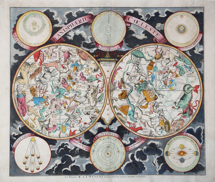
Double hemisphere celestial map, showing constellations of the northern and southern hemispheres.
Most of the constellations are depicted as figures according to classical mythology, with more recently named ones in the southern hemisphere rendered as scientific instruments.
The outer borders are decorated with six inset diagrams among clouds, showing the planetary models of Tycho Brahe, Ptolemy, and Copernicus, as well as the illumination of the moon by the sun, the revolution of the earth around the sun, and the effect of the moon on tides. A key to magnitudes of stars is in the center.
The selection and style of the constellations were based upon Firmamentum Sociescianum sive Uranographia (1687) by the Polish astronomer Johannes Hevelius, whose name is noted in the subtitle of the chart. The subtitle indicates that the chart also draws on the work of Edmund Halley, the astronomer for whom Halley’s Comet is named. The format of the map derives from Georg Christoph Eimmart, a Nuremberg astronomer.
The map offered here was published in Amsterdam c. 1750 by R. & J. Ottens.
The Ottens print and map publishing firm was founded by Joachim Ottens, a copper engraver. After his death in 1719, his widow and his two sons Reinier (1698-1750) and Josua (1704-1765) Ottens continued the business. In 1750, Reinier died and was succeeded by Josua's son, Reinier II (1729-1793). The Ottens firm is best known for their multi-volume atlases of Dutch maps assembled to order such as Atlas Major.
Etching, in good condition. A fine example with contemporary colouring.
|
Dekker, Elly, et al. Globes at Greenwich: A Catalogue of the Globes and Armillary Spheres in the National Maritime Museum, Greenwich. London: Oxford University Press and the National Maritime Museum, 1999. p. 327.
|
|
The family business of print and map selling was founded by Joachim Ottens but the active period of map publishing was concentrated in the years between 1720 and 1750 when the brothers, Reiner and Joshua, produced enormous collections of maps, some as large as 15 volumes.
These, including copies of practically all maps available at the time, were made up to order and were magnificently coloured. Besides these specially prepared collections they also issued single-volume atlases with varying contents as well as pocket atlases.
|
|
Dekker, Elly, et al. Globes at Greenwich: A Catalogue of the Globes and Armillary Spheres in the National Maritime Museum, Greenwich. London: Oxford University Press and the National Maritime Museum, 1999. p. 327.
|
|
The family business of print and map selling was founded by Joachim Ottens but the active period of map publishing was concentrated in the years between 1720 and 1750 when the brothers, Reiner and Joshua, produced enormous collections of maps, some as large as 15 volumes.
These, including copies of practically all maps available at the time, were made up to order and were magnificently coloured. Besides these specially prepared collections they also issued single-volume atlases with varying contents as well as pocket atlases.
|