| Reference: | s25125 |
| Author | Cornelis DE JODE |
| Year: | 1593 ca. |
| Zone: | Africa |
| Printed: | Antwerpen |
| Measures: | 450 x 325 mm |
| Reference: | s25125 |
| Author | Cornelis DE JODE |
| Year: | 1593 ca. |
| Zone: | Africa |
| Printed: | Antwerpen |
| Measures: | 450 x 325 mm |
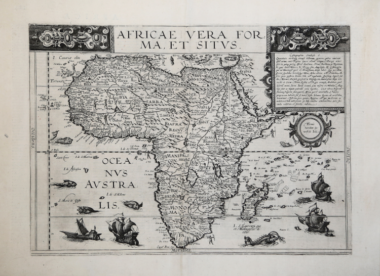
This is the De Jode family's second map of Africa, issued in 1593 by Cornelis de jode.
His father, Gerard, in 1578 published the atlas Speculum Orbis Terrarum, and evidently he intended to issue a revisited and expanded edition.
Due to his death, Cornelis realized the new edition and in 1593 published the atlas Speculum Orbis Terrae, adding ten new copperplates includind this map of Africa.
The large title at the top is flanked by some intricate design work and the oceans are decorated with sailing ships and sea monsters.
Cartographically, the map refers to Mercator for the river systems and Ortelius for other points. De Jode had originally intended his atlas to compete with Ortelius' Theatrum Orbis Terrarum. The competition between De Jode and Ortelius had been intense, but the better-connected Ortelius was able to influence events - possibly even ensuring a denial of the necessary Royal Privilege for De Jode until 1577.
De Jode's Speculum Orbis Terrarum was issued the next year. The Speculum had to compete against Ortelius' Theatrum Orbis Terrarum, in its eighth year of publication and already in its sixteenth edition, and was unable to make any serious impression on the market-hold enjoyed by Ortelius. De Jode's maps are thus appreciably rarer than those by Ortelius and are often better engravings.
A good impression of this finely engraved, rare and sought after map in overall good condition.
|
R. L. Betz "The Mapping of Africa…" (2007), map 27; O. I. Norwich, "Norwich's Maps of Africa", map 19
|
Cornelis DE JODE (Anversa 1568 - 1600)
|
Cornelis de Jode (1568 – October 17, 1600) was an Antwerp cartographer, engraver and publisher, He was the son and heir of Gerard de Jode, also a cartographer and publisher. Cornelis studied science at Academy of Douai, but it can be understood that his main education in the trade was at the hands of his father. On his father's death in 1591, Cornelis de Jode took over the work on his father's atlas, Speculum Orbis Terrarum. This had enjoyed publication in a single edition of 1578, overshadowed by the competition posed by Abraham Ortelius' (1527 - 1598) Theatrum Orbis Terrrum. Cornelis published a second edition, to which he added many updated maps to bring the work up to date with its competition. Despite the improvements brought to the atlas, both aesthetic and geographic, De Jode was unable to break Ortelius' grip on the market and there were no further editions of the atlas. After his death, the engraving plates were sold to Ortelius' executor Johannes Baptista Vrients (1552 - 1612), who was continuing to publish the Theatrum. Vrients would utilize several decorative plates from the Speculum, but the complete work and its maps were not published again - likely they were destroyed by Vrients to keep them from competing with his editions of the is Theatrum.
|
|
R. L. Betz "The Mapping of Africa…" (2007), map 27; O. I. Norwich, "Norwich's Maps of Africa", map 19
|
Cornelis DE JODE (Anversa 1568 - 1600)
|
Cornelis de Jode (1568 – October 17, 1600) was an Antwerp cartographer, engraver and publisher, He was the son and heir of Gerard de Jode, also a cartographer and publisher. Cornelis studied science at Academy of Douai, but it can be understood that his main education in the trade was at the hands of his father. On his father's death in 1591, Cornelis de Jode took over the work on his father's atlas, Speculum Orbis Terrarum. This had enjoyed publication in a single edition of 1578, overshadowed by the competition posed by Abraham Ortelius' (1527 - 1598) Theatrum Orbis Terrrum. Cornelis published a second edition, to which he added many updated maps to bring the work up to date with its competition. Despite the improvements brought to the atlas, both aesthetic and geographic, De Jode was unable to break Ortelius' grip on the market and there were no further editions of the atlas. After his death, the engraving plates were sold to Ortelius' executor Johannes Baptista Vrients (1552 - 1612), who was continuing to publish the Theatrum. Vrients would utilize several decorative plates from the Speculum, but the complete work and its maps were not published again - likely they were destroyed by Vrients to keep them from competing with his editions of the is Theatrum.
|