
| Reference: | S49967 |
| Author | Johannes JANSSONIUS |
| Year: | 1650 ca. |
| Zone: | Sea of ??Ethiopia |
| Printed: | Amsterdam |
| Measures: | 555 x 435 mm |
| Reference: | S49967 |
| Author | Johannes JANSSONIUS |
| Year: | 1650 ca. |
| Zone: | Sea of ??Ethiopia |
| Printed: | Amsterdam |
| Measures: | 555 x 435 mm |
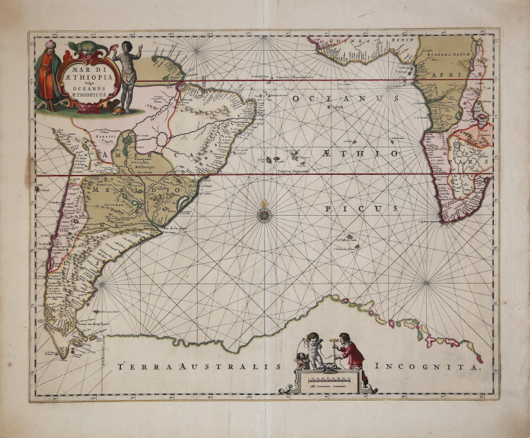
A beautiful nautical chart by Johannes Janssonius of the South Atlantic, showing the coasts of South America, southwest Africa, and an imaginary Terra Australis.
The ocean waters are crisscrossed by rhumb lines, which help the navigator establish a course. Both continents are also marked by waterways, with Lake Zaire, the Amazon River, and the Rio de la Plata being the most notable features. Tierra del Fuego is shown with a southerly thrust, a misunderstanding of the connection of the islands near Cape Horn to the larger archipelago. The southwestern coastline is still uncertain. The Le Maire Strait, between Tierra del Fuego and Staten Land, is depicted. The strait is named after the merchant Isaac Le Maire, who financed the voyage led by his son Jacob and Willem Schouten, who discovered the new route to the Pacific during their circumnavigation (1615–1617). Another strait on the other side of Staten Land is named after Brouwer. As part of a Dutch West India Company expedition to Chile, Brouwer led a fleet from Recife, Brazil, in 1643. The Company wanted to join a revolt already sparked by the Araucano Indians, attempting to destabilize Spanish power. Brouwer sailed his fleet eastward, discovering that Le Maire's Staten Land was insular. Brouwer Strait is near the most striking feature of this map, the imposing outline of Terra Australis Incognita. The coastline, composed of both solid land and small islands, extends almost the entire length of the map.
The map is taken from Water-weereld, the first large-format nautical atlas, which appeared in 1650, published by Johannes Janssonius as part five of the Novus Atlas. The description of the land, Janssonius wrote in the introduction to his Water-weereld, does not end at the coasts. This was the origin of the first true sea atlas: a collection of nautical charts, bound together in folio format, for general use rather than merely practical purposes. The Water-weereld contained twenty-three nautical charts and thirteen land charts. The accompanying texts contained only general information and had little to do with navigational problems. The publication of the Water-weereld had a domino effect on other publishers who until then had focused exclusively on nautical works. Janssonius had discovered and exploited a gap in the cartographic market, which also represented easier ground for publishers who, already having access to nautical charts, were now able to compile them in a new way to reach a wider audience.
Etching, with contemporary coloring, in excellent condition.
Johannes JANSSONIUS (1588-1664)
|
Johannes Janssonius, more commonly known to us as Jan Jansson, was born in Arnhem where his father was a bookseller and publisher (Jan Janszoon the Elder). In 1612 he married the daughter of the cartographer and publisher Jodocus Hondius, and then set up in business in Amsterdam as a book publisher. In 1616 he published his first maps of France and Italy and from then onwards he produced a very large number of maps, perhaps not quite rivalling those of the Blaeu family but running a very close second in quantity and quality. From about 1630 to 1638 he was in partnership with his brother-in-law, Henricus Hondius, issuing further editions of the Mercator/Hondius atlases to which his name was added. On the death of Henricus he took over the business, expanding the atlas still further, until eventually he published an 11-volume Atlas Major on a scale similar to Blaeu's Atlas Major.
The first full edition of Jansson's English County Maps was published in 1646 but some years earlier he issued a number of British maps in the Mercator/Hondius/Jansson series of atlases (1636-44); the maps were printed from newly engraved plates and are different from the later 1646 issue and are now rarely seen (see Appendix B for further details).
In general appearance Jansson's maps are very similar to those of Blaeu and, in fact, were often copied from them, but they tend to be more flamboyant and, some think, more decorative.
After Jansson's death his heirs published a number of maps in an Atlas Contractus in 1666 and later still many of the plates of his British maps were acquired by Pieter Schenk and Gerard Valck, who published them again in 1683 as separate maps.
|