
| Reference: | S43950 |
| Author | Sebastian Münster |
| Year: | 1542 |
| Zone: | Africa |
| Printed: | Basle |
| Measures: | 395 x 285 mm |
| Reference: | S43950 |
| Author | Sebastian Münster |
| Year: | 1542 |
| Zone: | Africa |
| Printed: | Basle |
| Measures: | 395 x 285 mm |
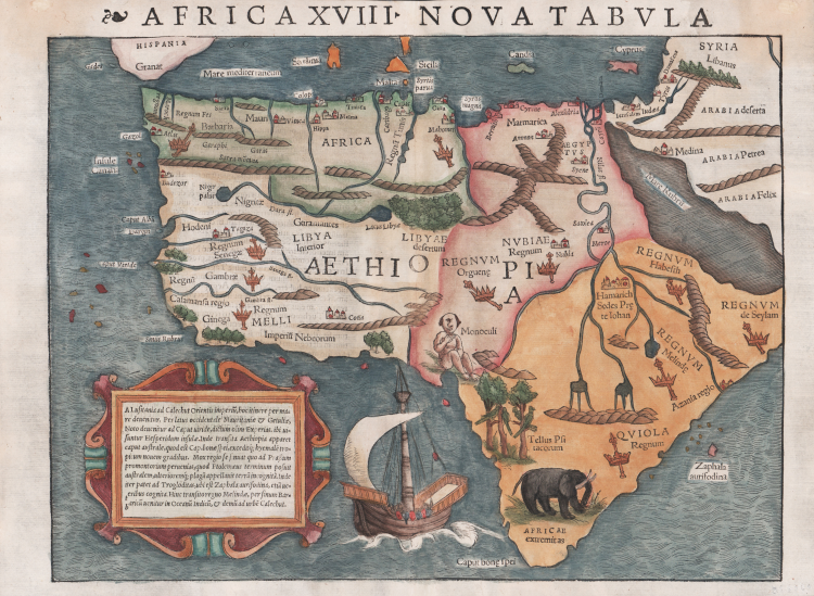
The first state, second issue of “the earliest, readily available, printed map to show the entire continent of Africa” (Betz). From Munster’s Geographia Universalis Latin edition of 1542.
Richly evocative of its early period, it is embellished with a galleon in full sail, a relatively realistic elephant, parrots, and a Cyclops. The map "is based partly on Ptolemaic, partly on Portuguese and partly on Arabic sources" (Tooley), the overall shape of the continent having been derived from the Portuguese. Betz believes “a source for the interior of North Africa may have been the Descrittione dell‘Africa written in manuscript by al Hassan (Leo Africanus) in 1526).” As would be the case with virtually all 16th and 17th century maps of Africa, Munster’s depiction of the Nile and its headwaters follows that of Ptolemy, with the source of the White Nile presented as two lakes fed by streams emanating from Ptolemy’s Mountains of the Moon. In approximate accord with reality, another lake is shown as the source of the Blue Nile (though considerably to the south of Lake Tana).
This highly important map represents the earliest reasonably obtainable map to depict the entire continent of Africa. Africa XVIII, Nova Tabula, is a fantastic visual synergy of archaic imagination and recent exploration. The overall shape of the continent is quite well defined, having been extensively explored by the Portuguese since the time of Prince Henry the Navigator in the mid-fifteenth-century, a point highlighted by the appearance of a caravel in the lower part of the map. Africa's various kingdoms are denoted by pictorial symbols of a crown and sceptre. Following Ptolemaic tradition, the Nile has its source in a series of lakes that lie at the foot of the mysterious Mountains of the Moon. The land around the Cape of Good Hope in South Africa is embellished by the appearance of an elephant, and exotic parrots occupy trees in Angola. Most amusingly, near the coast of east Africa, the "Monoculi," or one-eyed man imagined by Classical writers sits in wait for some hypothetical European visitor.
Münster was a brilliant polymath and one of the most important intellectuals of the Renaissance era. Educated at Tübingen, his surviving college notebooks, Kollegienbuch, reveal a mind of insatiable curiosity, especially with regards to cosmography. Münster later became a professor of Hebrew at Heidelberg, and then from 1529 at the University of Basle. In the 1530s, he turned his attentions to translating Ptolemy's Geography, adding new material that related to the lands newly discovered in Africa, the Americas and Asia. The result was the publication of his highly regarded Geographia Universalis, first printed in 1540.
The present map is from the second edition, but still represents the first-state of the map, as the same unaltered woodblock from the initial printing was employed in the production of the second edition.
Woodcut, with later hand colour, small defects at vertical center fold perfectly restored, otherwise in excellent condition.
Bibliografia
Betz, Mapping of Africa, n. 3 variant 2; Norwich, O.I. Maps of Africa, Map 2; Tooley, The Printed Maps of the Whole of the Continent of Africa, Part 1 (1500-1600), n. 6.
Sebastian Münster (1488 - 1552)
|
Sebastian Münster was a German cartographer, cosmographer, and Hebrew scholar whose Cosmographia (1544; "Cosmography") was the earliest German description of the world and a major work - after the Nuremberg Chronicle of 1493 - in the revival of geography in the 16th-century Europe. Altogether, about 40 editions of the Cosmographia appeared during 1544-1628. Although other cosmographies predate Münster's, he is given first place in historical discussions of this sort of publication, and was a major influence on his subject for over 200 years.
In nearly all works by Münster, his Cosmographia is given pride of place. Despite this, we still lack a detailed survey of its contents from edition to edition, along the years from 1544 to 1628, and an account of its influence on a wide range of scientific disciplines. Münster obtained the material for his book in three ways. He used all available literary sources. He tried to obtain original manuscript material for description of the countryside and of villages and towns. Finally, he obtained further material on his travels (primarily in south-west Germany, Switzerland, and Alsace). The Cosmographia contained not only the latest maps and views of many well-known cities, but included an encyclopaedic amount of details about the known - and unknown - world and undoubtedly must have been one of the most widely read books of its time.
Aside from the well-known maps and views present in the Cosmographia, the text is thickly sprinkled with vigorous woodcuts: portraits of kings and princes, costumes and occupations, habits and customs, flora and fauna, monsters and horrors. The 1614 and 1628 editions of Cosmographia are divided into nine books. Nearly all the sections, especially those dealing with history, were enlarged. Descriptions were extended, additional places included, errors rectified.
|