
| Reference: | S40828 |
| Author | Hendrick HONDIUS |
| Year: | 1663 |
| Zone: | The World |
| Printed: | Amsterdam |
| Measures: | 545 x 380 mm |
| Reference: | S40828 |
| Author | Hendrick HONDIUS |
| Year: | 1663 |
| Zone: | The World |
| Printed: | Amsterdam |
| Measures: | 545 x 380 mm |
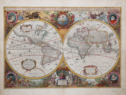
Stunning two-hemisphere world map, an iconic work from the golden age of Dutch cartography.
Embellished cartouches and whimsical illustrations make this map an excellent example of Baroque-style cartography. Surrounded by mythical scenes and fantastic beasts, the world map itself includes fascinating illustrations of sailing ships, sea monsters, and fish.
The map is decorated in the four corners with portraits of Claudius Ptolemy, Jodocus Hondius, Gerad Mercator and Julius Caesar. The upper part features the celestial globe embellished with festoons while, in the lower part, the allegorical figure of Europe receives gifts from Africa, Asia and America, a depiction reflecting the dominance of European maritime powers at the time. On the sides are depicted as usual the four elements, Fire, Air, Earth and Water. The two hemispheres also feature three small panels, one of which depicts the discovery of America by Christopher Columbus.
In addition to the many beautiful illustrations and cartographic details, some geographical features included in this map are noteworthy, such as California as an island, the river networks and lakes of North America, and the coastline of Australia. In South America, the Strait of Le Maire now appears east of the Strait of Magellan. The Strait of Le Maire had only been discovered fifteen years before the publication of this map, when Jacob Le Maire and Willem Schouten conducted a circumnavigation to undermine the Dutch East India Company's (VOC) trade monopoly. Innovations also include the northern coast of Australia extending toward New Guinea and a new drawing of northeastern Canada with Baffin Island (referred to as 'Queen Anne's forland') now shown completely surrounded by sea. The inclusion of the Australian coast in this map traces the beginning of Dutch knowledge of the Australian continent, when news of an "unknown southern land mass" was rapidly spreading.
Four versions of this map were made between 1630 and 1666; due to its popularity, the map also served as a basis for other cartographers. The first state of the map bears the date 1630; the second state sees the date changed to 1641 and the addition of the imprint Amstelodami Excudit Ioannes Ianssonius at the bottom. A third state - as this example - bears the date 1663 and a final reprint that of 1666. The first two editions of Hondius' world map are part of the Atlas Sive Cosmographicae Meditationes de Fabrica Mundi et Fabricati Figura, the Mercator-Hondius atlas first published by the cartographer's father, Joducus Hondius, in 1606. Jodocus acquired plates of Mercator's work, reprinting and supplementing them with an increasing number of his maps. The third edition was included (1663) in Jan Jansson's Atlas Contractus and Hendrick Van Loon's maritime atlases. The last issue (1666), on the other hand, is part of Jannsonius's Atlas Major.
The cartographer Hendrick [Henricus] Hondius (Amsterdam 1597-1651) was the son of the famous Joducus Hondius, whose portrait appears at lower left. While working with his father, Henricus was instrumental in the expansion of the Atlas Sive Cosmographicae Meditationes de Fabrica Mundi et Fabricati Figura. When his father died in 1612, Henricus and his brother, Jodocus the Younger [Jodocus II Hondius], took over the intaglio business. In 1621 he opened his own store, where he continued to publish new editions of Mercator's atlas. Later, he collaborated with his brother-in-law Jan [Johannes] Janssonius, with whom he continued to develop and enrich the Atlas Sive Cosmographicae Meditationes de Fabrica Mundi et Fabricati Figura.
Etching, printed on contemporary laid paper and finely hand-colored, in very good condition. Example of the third state of four with the date 1663 and the imprint Amstelodami Excudit Ioannes Ianssonius.
Bibliografia
Rodney W. Shirley, The Mapping of the World: Early Printed World Maps, 1472-1700, (Riverside, CT: Early World Press, 2001), map 336; Glen McLaughlin with Nancy H. Mayo, The Mapping of California as an Island: An Illustrated Checklist California Map Society Occasional Papers, 5 (1995).
Hendrick HONDIUS (Amsterdam 1597 - 1651)
|
Son of Jodocus Hondius (1563-1612) - engraver, cartographer, printer and publisher - in 1627 he began working in the family publishing business, managed, after the death of his father, by his mother and the printer Johannes Janssonius, who in 1612 had married Hendrick's (lat. Henricus) sister, Elisabeth. The Hondius typography was one of the most important of the time, even thanks to the collection of Mercator’s plates and the pubbication of many charts and atlases. In 1604, Hondius bought the copperplates of Mercator’s Atlas at the auction of Gerard Jr.’s effects. He added another forty maps, including new maps of the Continents and important regional maps of the Americas, before publishing a new edition of the Atlas, in 1606, in competition with Ortelius’ Theatrum. As many of the maps were more up-to-date, the Mercator-Hondius Atlas effectively superseded Ortelius’ Theatrum. On his death in 1612 his widow, Coletta van den Keere continued the business; from 1619 onwards their son Henry (II) (1597-1651) took over. From 1633 publication was carried on in co-operation with Jan Jansson Jr., Henry’s brother-in-law.
|