| Reference: | s34967 |
| Author | Henrick SCHERER |
| Year: | 1703 |
| Zone: | The World |
| Printed: | Munich |
| Measures: | 359 x 235 mm |
| Reference: | s34967 |
| Author | Henrick SCHERER |
| Year: | 1703 |
| Zone: | The World |
| Printed: | Munich |
| Measures: | 359 x 235 mm |
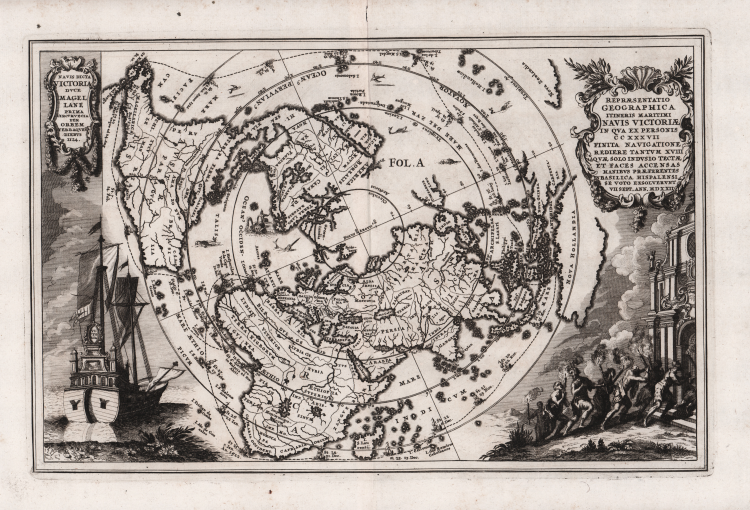
Map of the world, shown on a north polar projection and showing the entire world except the South Pole, California is shown as an island and the track of Magellan's voyage around the world is noted. There is a distorted portion of Australia noted as Nova Hollandia.
On the left is an illustration of Victoria, the only remaining ship from Magellan's Armada de Molucca that sailed from Seville in 1519 in search of a westward route to the Spice Islands.
On the right, the few expedition survivors (18 out of the original 237) are shown making their way to the Santa Marea de la Victoria church in Seville, where they went to give thanks for their safe return. The title cartouche includes the date of their return, September 7, 1522.
By Heinrich Scherer for his Atlas Novus exhibens orbem terraguem per naturae opera, historiae navae acveterus monumenta, artistique geographicae leges et praecepta...published in eight volumes from 1702-1710 in Munich. Scherer, a devout Jesuit, produced this geographical compendium to depict the Catholic hierarchy and the spread of Jesuit missions throughout the world.
Copper engraving, in very good condition.
|
Tooley, R.V. (Amer) p.132, #88, pl.60; Shirley, World, 626
|
Henrick SCHERER (Dilingen 1628 - Monaco 1704)
|
Heinrich Scherer was a devout Jesuit, and professor of mathematics at Munich. His 'Atlas Novus' contained maps of all other parts which showed the spread of Catholicism and Jesuit missions.
|
|
Tooley, R.V. (Amer) p.132, #88, pl.60; Shirley, World, 626
|
Henrick SCHERER (Dilingen 1628 - Monaco 1704)
|
Heinrich Scherer was a devout Jesuit, and professor of mathematics at Munich. His 'Atlas Novus' contained maps of all other parts which showed the spread of Catholicism and Jesuit missions.
|