
| Reference: | S4909 |
| Author | Eredi Johannes Baptiste HOMANN |
| Year: | 1784 |
| Zone: | The World |
| Printed: | Nurnberg |
| Measures: | 590 x 490 mm |
| Reference: | S4909 |
| Author | Eredi Johannes Baptiste HOMANN |
| Year: | 1784 |
| Zone: | The World |
| Printed: | Nurnberg |
| Measures: | 590 x 490 mm |
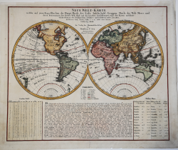
This interesting world map presents some curious cartography, given the date of the map.
The Great Lakes are shown as one huge body of water and California is strangely shaped with the Baja nearly appearing as an island. Australia includes several place names on the eastern coast, which resulted from Cook's discoveries in 1770.
However, Van Diemens Land is still shown connected to the mainland. The tracks of several late 18th century expeditions are shown. Color key and German text panel below the hemispheres.
Johann Baptist Homann was a German geographer and cartographer; in 1702 he founded his own publishing house. Homann acquired renown as a leading German cartographer, and in 1715 was appointed Imperial Geographer by Emperor Charles VI. In the same year he was also named a member of the Prussian Academy of Sciences in Berlin. In 1716 Homann published his masterpiece Grosser Atlas ueber die ganze Welt; numerous maps were drawn up in cooperation with the engraver Christoph Weigel the Elder. Homann died in Nuremberg in 1724 and was succeeded by his son Johann Christoph (1703-1730). The company carried on upon his death as Homann heirs company, managed by Johann Michael Franz and Johann Georg Ebersberger. After subsequent changes in management the company folded in 1852.
Etching with fine later hand colour, very good condition.
Eredi Johannes Baptiste HOMANN (1730 - 1813)
|
Johann Baptist Homann (20 March 1664 – 1 July 1724) was a German geographer and cartographer
born in Oberkammlach near Kammlach in the Electorate of Bavaria. Although educated at a Jesuit school, and preparing for an ecclesiastical career, he eventually converted to Protestantism and from 1687 worked as a civil law notary in Nuremberg. He soon turned to engraving and cartography; in 1702 he founded his own publishing house. Homann acquired renown as a leading German cartographer, and in 1715 was appointed Imperial Geographer by Emperor Charles VI. Giving such privileges to individuals was an added right that the Holy Roman Emperor enjoyed. In the same year he was also named a member of the Prussian Academy of Sciences in Berlin. Of particular significance to cartography were the imperial printing privileges (Latin: privilegia impressoria). These protected for a time the authors in all scientific fields such as printers, copper engravers, map makers and publishers. They were also very important as a recommendation for potential customers. In 1716 Homann published his masterpiece Grosser Atlas ueber die ganze Welt (Grand Atlas of all the World). Numerous maps were drawn up in cooperation with the engraver Christoph Weigel the Elder, who also published Siebmachers Wappenbuch. Homann died in Nuremberg in 1724. He was succeeded by his son Johann Christoph (1703-1730). The company carried on upon his death as Homann heirs company, managed by Johann Michael Franz and Johann Georg Ebersberger. After subsequent changes in management the company folded in 1852. The company was known as "Homann Erben", "Homanniani Heredes", or "Heritiers de Homann" abroad.
1702-07 Atlas novus terrarum
1712 Enlarged edition with re-issues to c.1753
c.1714 Neuer Atlas
re-issues to c. 1730
1719 Atlas Methodicus
1730 America Septentrionali Britannorum
1737 Grosser atlas
re-issues to c. 1770
|