| Reference: | ms4131 |
| Author | Nicolas SANSON |
| Year: | 1651 |
| Zone: | The World |
| Printed: | Paris |
| Measures: | 540 x 405 mm |
| Reference: | ms4131 |
| Author | Nicolas SANSON |
| Year: | 1651 |
| Zone: | The World |
| Printed: | Paris |
| Measures: | 540 x 405 mm |
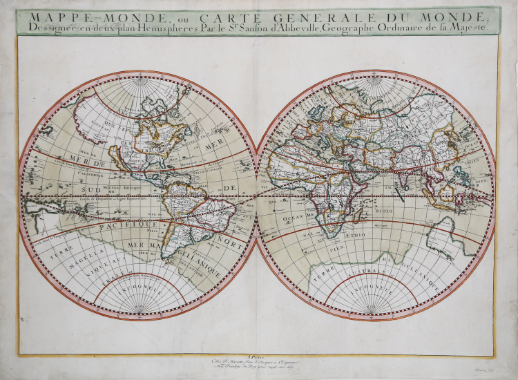
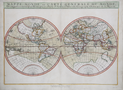
Sanson's map of the world. Unlike the earlier Dutch maps, Sanson's map focuses on the geographic and hydrographic information, the space around the double hemispheres left intentionally blank.
The outline of the continents and the illustrations of interior information is very accurate for the day. For instance, this map shows all five Great Lakes, a feature shown for the first time by Sanson. However, Sanson was not immune to the cartographic myths of his day.
The map shows a strange outline of a great southern continent, as well as several reflections of early knowledge of Australia, an interesting combination of old, mistaken beliefs and data from early explorations in the southern seas. Sanson also shows a large, mythical land of Jesso, El Dorado's Lake Parima in South America, and most interestingly, California depicted as an island.
In Sanson's world map, made at a time when cartographers were first developing a scientific picture of the world, we can see the overlap of the old and new world views by the dominant mapmaker of his day.
Map taken from Cartes Gènerales de toutes les parties du Monde by Sanson.
The maps were compiled by Nicolas Sanson who published his atlas in 1654, with 100 maps, and printed by Pierre Mariette; they were issued progressively from 1630.
Sanson was the most noted French cartographer in modern history. Mapmaker to Louis XIV, King of France, Sanson endowed his maps with the most recent geographical information as well as the finest and sharpest engraving of the period. His Cartes Generales de Toutes les Parties du Monde was the most important single product of French commercial cartography of the seventeenth century.
Copperplate, with fine later hand colour, very good condition.
|
R. W. Shirley, "The Mapping of the world", 390
|
Nicolas SANSON (Abbeville 1600 - Parigi 1667)
|
Nicolas Sanson (December 20, 1600 - July 7, 1667) and his descendants were the most influential French cartographers of the 17th century and laid the groundwork for the Golden Age of French Cartography. Sanson was born in Picardy, but his family was of Scottish Descent. He studied with the Jesuit Fathers at Amiens. Sanson started his career as a historian where, it is said, he turned to cartography as a way to illustrate his historical studies. In the course of his research some of his fine maps came to the attention of King Louis XIII who, admiring the quality of his work, appointed Sanson Geographe Ordinaire du Roi. Sanson's duties in this coveted position included advising the king on matters of geography and compiling the royal cartographic archive. In 1644 he partnered with Pierre Mariette, an established print dealer and engraver, whose business savvy and ready capital enabled Sanson to publish an enormous quantity of maps. Sanson's corpus of some three hundred maps initiated the golden age of French mapmaking and he is considered the 'Father of French Cartography.' His work is distinguished as being the first of the 'Positivist Cartographers,' a primarily French school of cartography that valued scientific observation over historical cartographic conventions. The practice result of the is less embellishment of geographical imagery, as was common in the Dutch Golden Age maps of the 16th century, in favor of conventionalized cartographic representational modes. Sanson is most admired for his construction of the magnificent atlas Cartes Generales de Toutes les Parties du Monde. Sanson's maps of North America, Amerique Septentrionale (1650), Le Nouveau Mexique et La Floride (1656), and La Canada ou Nouvelle France (1656) are exceptionally notable for their important contributions to the cartographic perceptions of the New World. Both maps utilize the discoveries of important French missionaries and are among the first published maps to show the Great Lakes in recognizable form. Sanson was also an active proponent of the insular California theory, wherein it was speculated that California was an island rather than a peninsula. After his death, Sanson's maps were frequently republished, without updates, by his sons, Guillaume (1633 - 1703) and Adrien Sanson (1639 - 1718). Even so, Sanson's true cartographic legacy as a 'positivist geographer' was carried on by others, including Alexis-Hubert Jaillot, Guillaume De L'Isle, Gilles Robert de Vaugondy, and Pierre Duval.
|
|
R. W. Shirley, "The Mapping of the world", 390
|
Nicolas SANSON (Abbeville 1600 - Parigi 1667)
|
Nicolas Sanson (December 20, 1600 - July 7, 1667) and his descendants were the most influential French cartographers of the 17th century and laid the groundwork for the Golden Age of French Cartography. Sanson was born in Picardy, but his family was of Scottish Descent. He studied with the Jesuit Fathers at Amiens. Sanson started his career as a historian where, it is said, he turned to cartography as a way to illustrate his historical studies. In the course of his research some of his fine maps came to the attention of King Louis XIII who, admiring the quality of his work, appointed Sanson Geographe Ordinaire du Roi. Sanson's duties in this coveted position included advising the king on matters of geography and compiling the royal cartographic archive. In 1644 he partnered with Pierre Mariette, an established print dealer and engraver, whose business savvy and ready capital enabled Sanson to publish an enormous quantity of maps. Sanson's corpus of some three hundred maps initiated the golden age of French mapmaking and he is considered the 'Father of French Cartography.' His work is distinguished as being the first of the 'Positivist Cartographers,' a primarily French school of cartography that valued scientific observation over historical cartographic conventions. The practice result of the is less embellishment of geographical imagery, as was common in the Dutch Golden Age maps of the 16th century, in favor of conventionalized cartographic representational modes. Sanson is most admired for his construction of the magnificent atlas Cartes Generales de Toutes les Parties du Monde. Sanson's maps of North America, Amerique Septentrionale (1650), Le Nouveau Mexique et La Floride (1656), and La Canada ou Nouvelle France (1656) are exceptionally notable for their important contributions to the cartographic perceptions of the New World. Both maps utilize the discoveries of important French missionaries and are among the first published maps to show the Great Lakes in recognizable form. Sanson was also an active proponent of the insular California theory, wherein it was speculated that California was an island rather than a peninsula. After his death, Sanson's maps were frequently republished, without updates, by his sons, Guillaume (1633 - 1703) and Adrien Sanson (1639 - 1718). Even so, Sanson's true cartographic legacy as a 'positivist geographer' was carried on by others, including Alexis-Hubert Jaillot, Guillaume De L'Isle, Gilles Robert de Vaugondy, and Pierre Duval.
|