
| Reference: | MMS1419 |
| Author | Athanasius KIRCHER |
| Year: | 1665 |
| Zone: | The World |
| Printed: | Amsterdam |
| Measures: | 555 x 400 mm |
| Reference: | MMS1419 |
| Author | Athanasius KIRCHER |
| Year: | 1665 |
| Zone: | The World |
| Printed: | Amsterdam |
| Measures: | 555 x 400 mm |
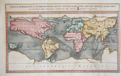
Extraordinary map, both form the physical and hydrographic point of view, depicting ocean currents, volcanoes and deep-sea chasms.
The map is taken from Kircher’s Mundus Subterraneus .
The Jesuit scholar, Athanasius Kircher, was one of the first compilers of semi-scientific knowledge about the physical features of the world.
This map expounds on Kircher's theories by noting the abysses and the currents they create as well as the locations of the world's known volcanoes. Between the Mediterranean Sea, the Black Sea, the Caspian Sea, and the Persian Gulf, Kircher theorized massive tunnels and a complex interchange of water flows.
These tunnels are noted most particularly between the Black and Caspian Sea and between the Mediterranean and the Persian Gulf. Antarctica is shown along the southern part of the map.
In the North a great open northwest passage is depicted running all the way across the map. Shows New Guinea and a suggestion of Australia attached to the 'Australsis Incognita' mainland. Africa is shown with considerably greater accuracy than many maps drawn hundreds of years later – particularly with regard to Niger and Nile River Systems. North America and South America are both wildly malformed, indicating a relatively sketchy knowledge of the continent. Korea is shown as an Island and Japan appears as only a single island.
Published in a Dutch edition of Kircher's famous Subterranean World by Johann Waesberger.
Kircher entered the Society of Jesus on October 2, 1618. He was teaching philosophy and mathematics in Würzburg, when the victories of the Swedes in Germany forced him to take refuge first in France, in Avignon, then in Vienna, whence, in 1635, he was called to the chair of mathematics in the Colleggio Romano. He dealt with philology (Prodromus coptus, Rome 1636; Lingua aegyptiaca restituta, 1643); physics (Ars Magnesia, Würzburg 1631; Specula melitensis, Naples 1638; Ars magnae lucis et umbrae, Rome 1645); sacred liturgy (Rituale Ecclesiae aegyptiacae, Rome 1647); of astronomy (Itinerarium extaticum, Rome 1655); of natural history (Mundus subterraneus, Amsterdam 1665); of mathematics (Organum mathematicum, Würzburg 1668); of music (Musurgia universalis, Rome 1660; Phonurgia nova, Kempten 1673) and more. He also attempted Egyptology, to which belong the three volumes entitled Oedipus Aegyptiacus (Rome 1652), with which he believed he had discovered the key to the interpretation of hieroglyphics. Turning to the study of Chinese civilization he gave birth to China monumentis qua sacris qua profanis... illustrata (Rome 1667). Kircher also has a notable place in the history of geographic science, not so much for the bold and often abstruse hypotheses he formulated (especially in Mundus subterraneus) to explain certain physical phenomena, such as the surface and subterranean circulation of water, but for the indigestible and unelaborated collection of data and facts about distant countries that he had from Jesuit travelers and missionaries; to him is due the credit of having outlined the first sketch of a map of sea currents, and also that of having called attention to the phenomena, which today we say karst, although he collected and divulged in this respect many fantastic and extravagant reports, which, moreover, were generally believed in his time. Kircher is also the author of chorographic works of a historical-geographical nature, among which the most notable is perhaps his Latium (1671). He was also a diligent collector of classical, Christian, Oriental and South American antiquities. Of the relics he collected, the museum that bears his name was formed and is preserved in the Roman College (Kircherian Museum, now the Prehistoric and Ethnographic Museum).
Etching with fine later hand colour, in excellent condition.
|
Shirley, The Mapping of the World, 459.
|
Athanasius KIRCHER (Geisa 1601 circa - Roma 1680)
|
German Jesuit educated in Fulda, was one of the most remarkable men of his time, seemingly interested in every aspect of life. He was an expert on China and its languages; Egypt and Ethiopia and the source of the Nile; he translated oriental scripts and hieroglyphics; made a scientific study of the evolution of the earth and its physical features; he wrote a treatise on the reasons of magnetic compass variations; and, in the middle of all of that, found time to invent the magic lantern, for which he is probably best remembered. Maps in his book Mundus Subterraneus were the first to describe tides and ocean currents beside showing the sites of all volcanoes known at that time.
|
|
Shirley, The Mapping of the World, 459.
|
Athanasius KIRCHER (Geisa 1601 circa - Roma 1680)
|
German Jesuit educated in Fulda, was one of the most remarkable men of his time, seemingly interested in every aspect of life. He was an expert on China and its languages; Egypt and Ethiopia and the source of the Nile; he translated oriental scripts and hieroglyphics; made a scientific study of the evolution of the earth and its physical features; he wrote a treatise on the reasons of magnetic compass variations; and, in the middle of all of that, found time to invent the magic lantern, for which he is probably best remembered. Maps in his book Mundus Subterraneus were the first to describe tides and ocean currents beside showing the sites of all volcanoes known at that time.
|