
| Reference: | S48002 |
| Author | Sebastian Münster |
| Year: | 1552 |
| Zone: | The World |
| Printed: | Basle |
| Measures: | 385 x 315 mm |
| Reference: | S48002 |
| Author | Sebastian Münster |
| Year: | 1552 |
| Zone: | The World |
| Printed: | Basle |
| Measures: | 385 x 315 mm |
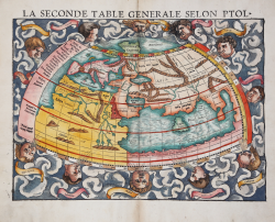
An attractive example of Sebastian Munster's map of the world according to Claudius Ptolemy. The map details the world prior to the great age of discovery. As such, it covers only the 'Old World' from the Atlantic (Pillars of Hercules) to Indochina and from the Arctic to the Equator. The map is surrounded by classical illustrations of Aiolos, or wind heads, among clouds.
It is the Ptolemaic vision of the world we see illustrated here. Europe is easily identifiable in the upper left. Africa becomes a massive continent seemingly without end. It is however defined by two great river systems, the Niger, extending form the Atlantic, and the Nile. Arabia and the Persian Gulf are clearly recognizable. The Indian Ocean is entirely enclosed. Tapobrana, in the midst of this great sea, is mostly probably the island of Ceylon or modern-day Sri Lanka, here oversized due to its importance in the classical spice trade. India, appearing amorphously just to the north, is undersized by comparison. Further east a territory called India Extra Gangers (India beyond the Ganges) is in fact Southeast Asia and the Malay Peninsula. The map extends only so far south as the Equator as Ptolemy believe that as one traveled south they entered an 'Tepid Zone' inhabited only by monsters.
This map was first published in 1540 Geographia by Heinrich Petri. This example comes from the Cosmographiae Universalis, Frenche edition, published with the title La cosmographie universelle, contenant la situation de toutes les parties du monde Basel, 1552 [first French edition].
The Cosmographiae Universalis of Sebastian Münster (1488-1552), printed for the first time in Basel in 1544 by the publisher Heinrich Petri, was updated several times and increased with new maps and urban representations in its many editions until the beginning of the next century. Münster had worked to collect information in order to obtain a work that did not disappoint expectations and, after a further publication in German embellished with 910 woodblock prints, arrived in 1550 to the final edition in Latin, illustrated by 970 woodcuts.
There were then numerous editions in different languages, including Latin, French, Italian, English and Czech. After his death in Münster (1552), Heinrich Petri first, and then his son Sebastian, continued the publication of the work. The Cosmographia universalis was one of the most popular and successful books of the 16th century, and saw as many as 24 editions in 100 years: the last German edition was published in 1628, long after the author's death. The Cosmographia contained not only the latest maps and views of all the most famous cities, but also a series of encyclopedic details related to the known, and unknown, world.
The particular commercial success of this work was due in part to the beautiful engravings (among whose authors can be mentioned Hans Holbein the Younger, Urs Graf, Hans Rudolph Manuel Deutsch, David Kandel).
Woodcut with fine later hand colour, in good condition.
Sebastian Münster (1488 - 1552)
|
Sebastian Münster was a German cartographer, cosmographer, and Hebrew scholar whose Cosmographia (1544; "Cosmography") was the earliest German description of the world and a major work - after the Nuremberg Chronicle of 1493 - in the revival of geography in the 16th-century Europe. Altogether, about 40 editions of the Cosmographia appeared during 1544-1628. Although other cosmographies predate Münster's, he is given first place in historical discussions of this sort of publication, and was a major influence on his subject for over 200 years.
In nearly all works by Münster, his Cosmographia is given pride of place. Despite this, we still lack a detailed survey of its contents from edition to edition, along the years from 1544 to 1628, and an account of its influence on a wide range of scientific disciplines. Münster obtained the material for his book in three ways. He used all available literary sources. He tried to obtain original manuscript material for description of the countryside and of villages and towns. Finally, he obtained further material on his travels (primarily in south-west Germany, Switzerland, and Alsace). The Cosmographia contained not only the latest maps and views of many well-known cities, but included an encyclopaedic amount of details about the known - and unknown - world and undoubtedly must have been one of the most widely read books of its time.
Aside from the well-known maps and views present in the Cosmographia, the text is thickly sprinkled with vigorous woodcuts: portraits of kings and princes, costumes and occupations, habits and customs, flora and fauna, monsters and horrors. The 1614 and 1628 editions of Cosmographia are divided into nine books. Nearly all the sections, especially those dealing with history, were enlarged. Descriptions were extended, additional places included, errors rectified.
|