
| Reference: | S43430 |
| Author | Pieter VANDER AA |
| Year: | 1702 |
| Zone: | The World |
| Printed: | Leyden |
| Measures: | 350 x 260 mm |
| Reference: | S43430 |
| Author | Pieter VANDER AA |
| Year: | 1702 |
| Zone: | The World |
| Printed: | Leyden |
| Measures: | 350 x 260 mm |
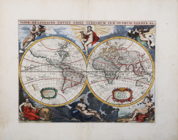
Fine example of Vander Aa's edition of Arnold Colom's very rare and imposing double-hemisphere map of the World, embellished mythological figures representing fire, air, day and night set against the skies and land, water against land- and seascapes.
Originally published by Jacob van Meurs in 1660, and reissued here by Van der Aa, this map is based on Arnold Colom's wonderfully graphic map from the first world maritime atlas. California is an island, separated from Nova Albion, which stretches towards Asia and off the map. The western coast of New Zealand appears, as do several other important Pacific islands. Australia is partially mapped and only the southern tip of Tasmania appears. Each hemisphere includes a strap work cartouche, one with the title. Superb engravings surround the map with representations of the gods Apollo and his sister Diana representing day and night with four female allegories of the elements of Fire, Air, Water and Earth.
The map was first published by J. Gottfried with the Dutch title Niewe Werelt Caart and was reissued by Pieter Vander Aa with his own imprint and the French title Nouveau Carte Du Monde re-engraved in the lower cartouche.
Pieter van der Aa (1659-1733) was a Dutch mapmaker and publisher who printed pirated editions of foreign bestsellers and illustrated books but is best known for his voluminous output of maps and atlases. Van der Aa was born to a German stonecutter from Holstein. Interestingly, all three van der Aa sons came to be involved in the printing business. Hildebrand was a copper engraver and Boudewyn was a printer.
Copperplate with fine later hand colour, very good condition.
Bibliografia
Shirley 417.
Pieter VANDER AA (1659 - 1733)
|
Records show that van der Aa, born in Leyden in 1659, made an early start in life by being apprenticed to a bookseller at the age of nine and starting on his own in business as a book publisher by the time he was twenty-three.
During the following fifty years he published an enormous amount of material, including atlases and illustrated works in every shape and size, two of them consisting of no less than 27 and 28 volumes containing over 3,000 maps and plates.
Most of his maps were not of the first quality and were certainly not original, but they are often very decorative and are collected on that account.
|