| Reference: | S51218 |
| Author | Charles François DELAMARCHE |
| Year: | 1806 ca. |
| Zone: | The World |
| Printed: | Paris |
| Measures: | 450 x 275 mm |
| Reference: | S51218 |
| Author | Charles François DELAMARCHE |
| Year: | 1806 ca. |
| Zone: | The World |
| Printed: | Paris |
| Measures: | 450 x 275 mm |
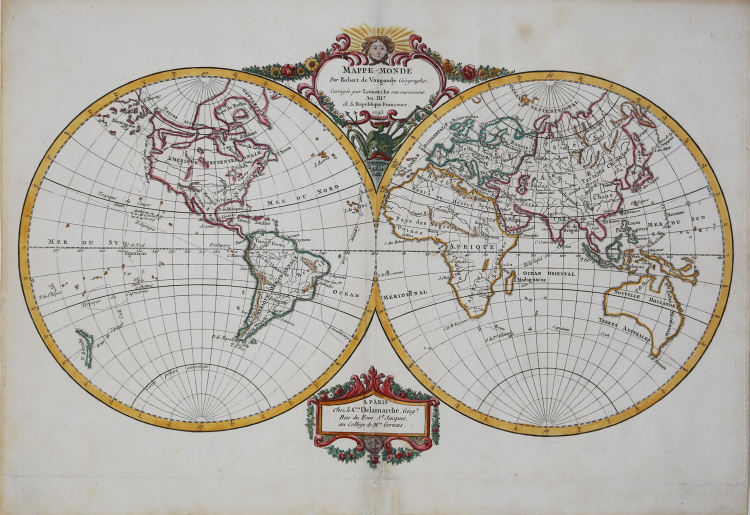
Mappe-Monde par Robert de Vaugondy Geographe. Corrigee et Augmentee des Nouvelles Decouvertes par C.F. Delamarche, son Successeur 1806
Decorative double hemisphere map of the World, published by C.F. Delamarche in Paris.
Unlike most of the maps of the period illustrating the Cook's Voyages, this map focuses solely on his third and final voyage, where Cook met his end at the hands of Hawaiian natives on February 14, 1779.
The map tracks Cook's Third Voyages from England to the Coast of Brazil, then through the Indian Ocean, past Terre de Diemen (Tasmania). Sailing through New Zealand's two main islands, sailed through the Friend (Cook) Islands and French Polynesia, to the Pacific Northwest. Proceeding north along the coast of British Columbia and Alaska, he reached the Behring Straits, before turning south for Hawaii. The tracks end with Cook's death, an interesting tribute to arguably the greatest naval explorer of the 18th Century.
Plate taken from the Recueil de cartes sur la géographie ancienne et moderne, à l'usage des élèves de l'Ecole Royale Militaire de Saint-Cyr, printed in Paris and published in several editions between 1806 and 1825.
Charles-François Delamarche (August 1740 – 31 October 1817) was a French geographer and mapmaker. One of the most important French geographers and mapmakers of the second half of the eighteenth century. Successor to Nicolas Sanson (1600 – 1667), Robert de Vaugondy (1686 – 1766), and Rigobert Bonne (1727 – 1794), whose atlases he reprinted. Also taught geography. In addition to maps and globes, his works include a treatise on the use of the sphere and celestial and terrestrial globes. In the treatise, he illustrates both the Ptolemaic and Copernican systems, as well as listing all the ancient and modern constellations. His son Félix Delamarche continued his work. Charles François Delamarche acquired Didier Robert de Vaugondy's collection in 1778, after having collaborated with him in the edition of atlases.
Etching, printed on contemporary laid paper, a fine later hand coloring, in excellent condition.
Bibliografia
Moreland-Bannister “Antique Maps A Collector’s Guide” Oxford 1989 pag.136 e 139.
Charles François DELAMARCHE (1740 – 1817)
|
One of the most important French geographers and mapmakers of the second half of the eighteenth century. Successor to Nicolas Sanson (1600 – 1667), Robert de Vaugondy (1686 – 1766), and Rigobert Bonne (1727 – 1794), whose atlases he reprinted. Also taught geography. In addition to maps and globes, his works include a treatise on the use of the sphere and celestial and terrestrial globes. In the treatise, he illustrates both the Ptolemaic and Copernican systems, as well as listing all the ancient and modern constellations.
|