| Reference: | S42724 |
| Author | Melchior TAVERNIER |
| Year: | 1661 |
| Zone: | The World |
| Printed: | Paris |
| Measures: | 330 x 340 mm |
| Reference: | S42724 |
| Author | Melchior TAVERNIER |
| Year: | 1661 |
| Zone: | The World |
| Printed: | Paris |
| Measures: | 330 x 340 mm |
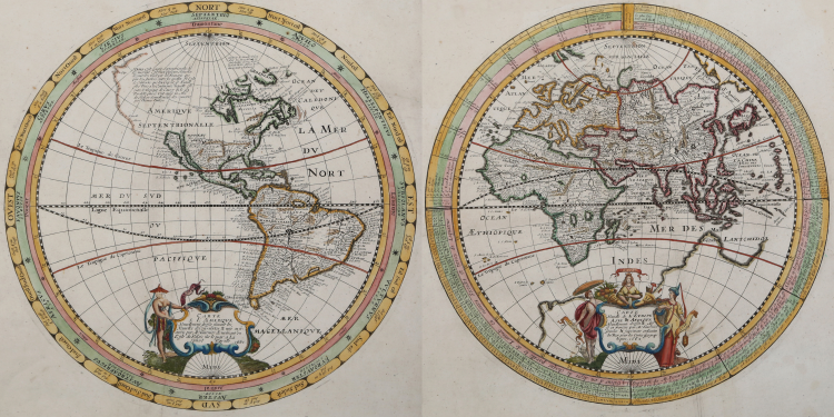
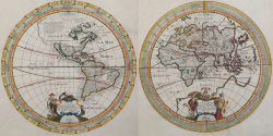
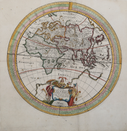
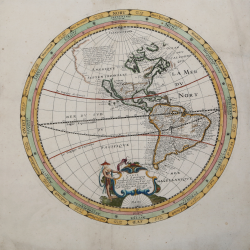
Together, 2 copper-engraved hemisphere maps, issued as a pair; hand colored. Each 330 cm. (11¾") in diameter. Striking pair of hemisphere maps, West and East, published by Melchior Tavernier.
Tavernier's map provides a fine blend of contemporary cartographic information with unique details in the concentric circles outside of the geographical hemisphere.
Cartographically, the map is a marvelous blend of information and conjecture. Tavernier treats the massive northwestern landmass to the north of California as conjecture, employing a lighter coastal outline to signify that the lands depicted are not known with certainty. California is shown as a curiously shaped island, not consistent with either the Briggs or Sanson models. There are extensive place names and notations on the maps, and each is graced with a fine pictorial cartouche. The Western Hemisphere shows a single Great Lake, and an expansive northwest coastline in North America. A notation describes Thomas Button's search for a Northwest Passage. In South America, there is a small Lake Parime in Guiana, and both the Amazon and Rio de la Plata flow from the large interior Lago de los Xarayes. In the Eastern Hemisphere, the large mythical southern continent fills the bottom of the map and the Dutch discoveries in Australia are not shown. Both hemispheres are enclosed in concentric circles giving compass points, notations and tables. These two hemisphere maps first appeared in 1639, printed on a single sheet.
In the outermost circle, Tavernier names the 32 compass point directions in French. In the center circle, are the names of the 12 Classical Winds described by Timothenes of Rhodes (circa 282 BC) in both Latin and the original Greek spellings. In the innermost circle, the 8 Winds of the Mediterranean (the modern compass points) are named (Tramontane, Greco (Grecale), Levante, Sirocco, Austral (Ostro or Mezzogiorno), Sebaca (Libeccio or Garbino), Ponent (Ponente) and Maestral (Mistral or Maestro).
Melchior Tavernier was a member of a large family involved in the publishing trade in Paris in the early years of the seventeenth century. Early in his career, he apparently collaborated with Henricus Hondius, as at least one of his early maps references Tavernier as the seller of a map engraved in Amsterdam, by Hondius. He is probably best known for his publication of a map of the Post Roads of France, which was copied many times until the end of the century. He also issued an atlas under the same title as J. le Clerc's Theatre Geographique, using many of Le Clerc's maps, but incorporating others from different sources. He published composite atlases and also published works for other cartographers, including N. Sanson, N. Tassin, and P. Bertius. He is not to be confused with his nephew of the same name (1594-1665), who also engraved maps for Nicolas Sanson.
Bibliografia
Shirley, R.W. (World) #349; Burden, P.D. #255.
Melchior TAVERNIER (1564 ca. - 1644)
|
He was a member of a large family involved in the publishing trade in Paris in the early years of the seventeenth century .He is probably best known for his publication of a map of the Post Roads of France which was copied many times until the end of the century.He also issued an atlas under the same title as J. Le Clerc’s Theatre Geographique,using many of Le Clerc’s maps,but incorporating others from the maps noted below ,he pubblished works for other cartographers,including N.Sanson ,N.Tassin,and P.Bertius.He is not to be confused with his nephew of the same name (1594-1665),who also engraved maps for Nicolas Sanson.
1632 Carte Geographique des Postes qui traversent la France
1658 re-issued by N.Sanson
1634 Theatre Geographique du Royaume de France
1640-42 Description de la Carte Generale de tout le Monde
|