
| Reference: | CO-500 |
| Author | Tipografia Valck & Schenk |
| Year: | 1700 ca. |
| Zone: | Bracciano |
| Printed: | Amsterdam |
| Measures: | 505 x 410 mm |
| Reference: | CO-500 |
| Author | Tipografia Valck & Schenk |
| Year: | 1700 ca. |
| Zone: | Bracciano |
| Printed: | Amsterdam |
| Measures: | 505 x 410 mm |
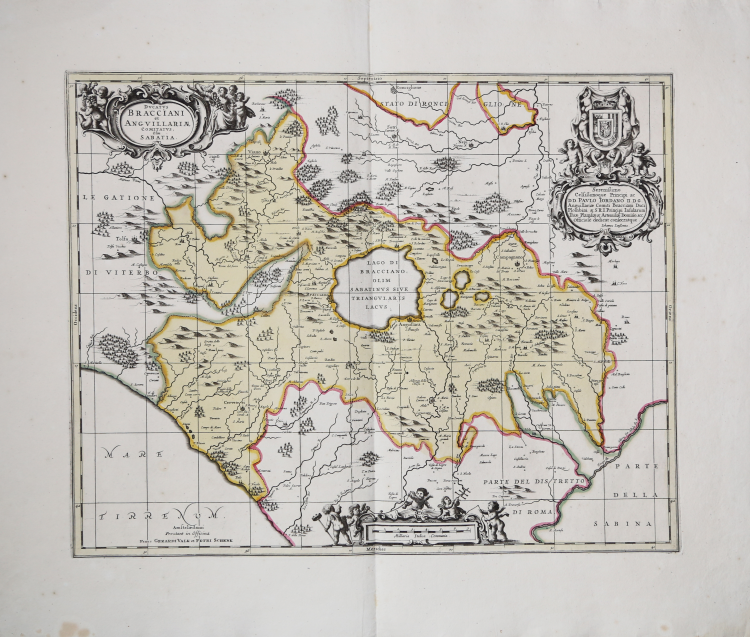
Rara edizione di Valck e Schenk della carta del Ducato di Bracciano di Janssonius.
Si tratta di una copia della carta di Bracciano di Johannes Blaeu (1662), a sua volta basata sull’importante rilievo di Giacomo Oddi (1600-16?) stampato a Roma nel 1640 circa.
Dal punto di vista cartografico si nota che la carta è completata a nord, dove include il rilievo del territorio di Nepi, Sutri e Ronciglione. Nel cartiglio compare la dedica di Janssonius al principe Paolo Giordano.
Il ducato di Bracciano è stato un feudo pontificio, situato intorno all'omonimo lago e amministrato da un ramo della famiglia Orsini con rango signorile (dal 1417) e ducale (dal 1560 al 1696).
Lo storico Campagnia, in una relazione manoscritta conservata presso l'Archivio Orsini, descrive il ducato di Bracciano come composto di "sette terre", menzionando, però, solo tre di esse: Bracciano, Anguillara e Cerveteri. Le altre quattro terre, considerando ragionevolmente l'estensione originaria del ducato (1560), erano Trevignano, Monterano, Campagnano e Formello. Completavano l'elenco altri feudi minori e tenute: Baccano, Bardella, Cantalupo, Castel Giuliano, Cesano, Galeria, Isola, Palo, Saracinesco, Scrofano, San Gregorio, Vicarello. In seguito, verranno aggiunte: Ischia, Monte Virginio, Oriolo, Rota, Viano, Rota, Baccano, Licenza, Pietraforte, Scarpa, Sorbo, Stigliano e Stracciacappe.
Sembra che la carta non sia mai stata una componente regolare dell'atlante Jansson, il che spiegherebbe la sua scarsità. Van der Krogt descrive la carta come un'aggiunta a pochi atlanti di Jansson, senza una chiara data di inizio; la prima data che fornisce è il 1675. La lastra del Janssonius verrà da pubblicata solo nell'edizione del 1675 dell'Atlas Major sive Cosmographia Universalis.
Il rame passò nelle mani degli stampatori Valck e Schenk che la rimisero in commercio con la sola aggiunta del reticolo geografico e dell'imprint editoriale "Prostant in Officina Amstelodmani apud Petri Schenk, et Ger. Valk C. P.". Il reticolo grafico ha una scansione di mezzo grado. La datazione, così come la provenienza di tale carta, ossia l'inserimento di tale carta in un atlante, è molto problematica. Petrus Schenk I (1660-1718 ca) fu incisore ed editore tedesco, trasferitosi giovanissimo ad Amsterdam dove divenne allievo di Gerad Valk (1656-1726) e del quale sposò la sorella Agatha nel 1687. L'associazione tra i due risale già ai primi anni 80 del Seicento; intorno al 1690 si trovarono ad acquistare gran parte dei rami di Janssonius che furono da loro editi con piccoli ritocchi e modifiche. È molto probabile che il rame sia stato stampato ancora e commercializzato anche nel corso del Settecento a opera degli eredi Leonard Valk (1675-ante 1755) e Petrus Schenk II (1698-1775).
Joannes Janssonius, figlio dell'editore di Arnhem Jan Janssen, sposò Elisabeth Hondius, figlia di Jodocus Hondius, ad Amsterdam nel 1612. Dopo il suo matrimonio, si stabilì in questa città come libraio ed editore di materiale cartografico. Nel 1618 si stabilì ad Amsterdam accanto alla libreria di Willem Jansz. Blaeu, entrando in una seria competizione. Le sue attività non riguardavano solo la pubblicazione di atlanti e libri, ma anche di mappe singole e un vasto commercio di libri con filiali a Francoforte, Danzica, Stoccolma, Copenaghen, Berlino, Koningsbergen, Ginevra e Lione. Nel 1631 iniziò a pubblicare atlanti insieme a Henricus Hondius. Nei primi anni 1640 Henricus Hondius lasciò l'attività di pubblicazione di atlanti completamente a Janssonius. La concorrenza con Joan Blaeu, figlio e successore di Willem, nella produzione di atlanti spinse Janssonius ad ampliare il suo Atlas Novus finalmente in un'opera di sei volumi, in cui furono inseriti un atlante marino e un atlante del Vecchio Mondo. Dopo la morte di Joannes Janssonius, il negozio e la casa editrice furono continuati dagli eredi sotto la direzione di Johannes van Waesbergen (c. 1616-1681), genero di Joannes Janssonius. Le matrici degli atlanti di Janssonius furono in seguito vendute a Schenk e Valck.
Incisione su rame, bella coloritura d'epoca, verso bianco, senza testo.
Bibliografia
Van der Krogt 1, Atlantes Neerlandici, n. 406.
Tipografia Valck & Schenk (attiva 1687 - 1711 circa)
|
Gerard Valk, or Gerrit Leendertsz Valck (1652-1726) together with his son Leonard, were the only significant publishers of globes in the Netherlands in the eighteenth century, enjoying an almost total monopoly in the first half of the 1700's. Initially an engraver and art dealer and having worked for map-sellers Christopher Browne and David Loggan in London between 1672 and 1679, Valk established the firm in Amsterdam in 1687. Initially, they published maps and atlases, but in 1700 the company moved the shop to the building previously occupied by map and globe-maker Jodocus Hondius. Around 1711, when he became a member of the bookseller's guild, Leonard Valk (1675-1746) came into partnership and his name started to appear alongside that of his father on the cartouches of the globes, although the earliest of these, both terrestrial and celestial, still bear the date 1700. Leonard naturally took over the business on his father's death in 1726 and following his own death in 1746 the firm was run by Maria Valk, cousin, and wife to Gerard.
Peter Schenk the Elder (1660-1711) moved to Amsterdam in 1675 and began to learn the art of mezzotint. In 1694 he bought some of the copperplate stock of the mapmaker Johannes Janssonius, which allowed him to specialize in the engraving and printing of maps and prints. He split his time between his Amsterdam shop and Leipzig and also sold a considerable volume of materials to London. Peter Schenk the Elder had three sons. Peter the Younger carried on his father’s business in Leipzig while the other two, Leonard and Jan, worked in Amsterdam. Leonard engraved several maps and also carried on his father’s relationship with engraving plates for the Amsterdam edition of the Histoire de l'Académie Royale des Sciences.
|