
| Reference: | CO-080 |
| Author | Antonio LAFRERI |
| Year: | 1564 ca. |
| Zone: | Tuscia |
| Printed: | Rome |
| Measures: | 495 x 385 mm |
| Reference: | CO-080 |
| Author | Antonio LAFRERI |
| Year: | 1564 ca. |
| Zone: | Tuscia |
| Printed: | Rome |
| Measures: | 495 x 385 mm |
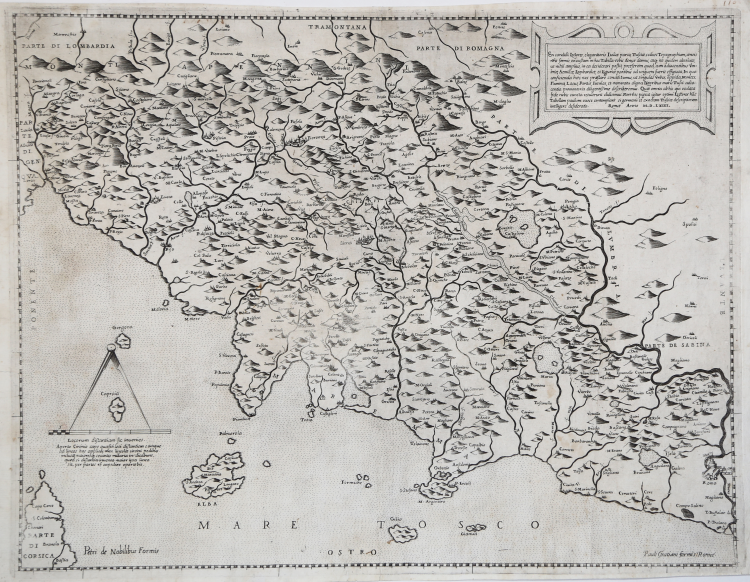
Anonymous map, printed in Rome in 1564; derivation of Girolamo Bellarmato's Chorographia Tusciae (1536), it is attributed to the printing house of Antonio Lafreri.
Example in the second state of three, with the added editorial addresses of Paolo Graziani and Pietro de Nobili, dated to about 1585. Paolo Graziani acquired part of the Lafreri’s stock in 1583 and then associated with Pietro de Nobili in 1585.
“Girolamo Bellarmato's (or Bellarmati's) Chorographia Tusciae represents the prototype of printed cartography of the region. Slightly trapezoidal in shape, it consists of four joined sheets. Although it lacks a graphic scale, from the value of degrees of latitude we can reconstruct the value of the reduction, which is about 1:325,000. In the long dedication to Valerio Orsini, general of the Medici army, the author specifies that the map is useful for his profession therefore presenting it as a tool for military, political and administrative use. This cartographic product is based on data derived from systematic direct observation, measurements and surveys made by the author on the territory. Attention is given to all geographical aspects; for population centers, the size of the depiction is related to the size of the population. The hydrography is very well taken care of, and the orography is well highlighted, which is drawn with cones, larger in size for the most important reliefs. This valuable and innovative work was taken as a model for many years to follow and had numerous derivations. As Biasutti (1908) notes, Gastaldi also used Bellarmato's survey to compose his map of the peninsula (1561). The work also formed the basis for the maps of the region that the Flemish Abraham Ortelius (1570) and Gerard Mercator (1587) included in their respective atlases. Only one example of the map is known today, preserved in the State Archives in Florence" (cf Cartografia e Topografia Italiana del XVI secolo, p. 1961).
The cartouche in the upper right corner includes a brief description to readers of the area represented: En candidi Lectores, elegantioris Italiae partis, Tusciae scilicet Topographiam, aeneis n[ost]ris formis excussam in hac Tabella vobis denuo damus, atque ita quidem absolute, ut nihil amplius, in ea desiderali possit, praesertim quod, cum adiacentibus Umbriae, Aemiliae, Lombardiae, et Liguriae partibus ad unguem fuerit effigiata. In qua conficienda haec nos praestare conati sumus, ut singulas urbes, oppida, Montes, Flumina, Lacus, Portus, Insulsas, et memoratu digna Littoribus maris Tusci adiacentia promontoria diligentissime describeremus. Quae omnia ab his qui oculata fide nobis cuncta retulerunt didicimus. Non Vos pigeat igitur optimi Lectores ha[n]c Tabellam paulum ociose contemplari sigermani et exactam Tusciae descriptionem intelligere desideratis. The editorial imprint follows: Romae Anno M.D.LXIIII. At lower right is the graphic scale of 30 miles (equal to mm 85) accompanied by the inscription: Locorum distantiam sic inuenies Aperto Circino cape quaesiti loci distantiam e amque ad lineas has applica, mox lineolae cercini pedibus inclusae maioresque secantes militaria in dìcabunt, quod si distantia inuenta maior ipsa linea sit, per partes re expedire oportebit. Orientation in the four sides in the center, naming the winds: TRAMONTANA, OSTRO, LEVANTE, PONENTE, north being at the top. Graduation in the margins is drawn, but without showing the values.
“Carta anonima, pubblicata a Roma nel 1564. Si tratta dell’ennesima derivazione romana della Toscana del Bellarmato, erroneamente attribuita da Woodward a Paolo Forlani. Questa tavola è molto simile alla carta del Salamanca edita a Roma nel 1558 circa (catalogo n. 993), con la quale condivide i dettagli geo-cartografici. Si possono notare alcuni cambiamenti nelle decorazioni; il disegno della scala grafica, priva anche qui delle miglia, è spostato nel mare, dove invece non sono rappresentate imbarcazioni. Siamo portati a pensare che la tavola sia realizzata da Antonio Lafreri dopo lo scioglimento della società con Francesco Salamanca (1563 circa) che era succeduto al padre. La mappa è presente nei cataloghi della tipografia Lafreri (1573 circa, n. 86), Stefano Duchetti (agosto 1581, n. 65), Paolo Graziani (settembre 1583, n. 55), Pietro de Nobili (maggio 1585, n. 22), indicata come “La Toscana”. La carta ebbe una seconda stesura, firmata da Pietro de Nobili e Paolo Graziani, che è databile al 1585 circa. Alla Raccolta Bertarelli è conservata un’ulteriore tiratura, con il nome degli editori abraso; questa edizione è sicuramente successiva alla chiusura della tipografia de Nobili (atto del maggio 1589), quando le lastre furono divise tra il figlio di Pietro, Marcello Clodio e Girolamo Arbotti” (cfr. Cartografia e Topografia Italiana del XVI secolo p. 1980).
Only two institutional examples of this map edition are described in Cartografia e Topografia Italiana del XVI secolo: Malta, National Library; Salzburg, Universitatsbibliothek.
Magnificent proof, printed on contemporary laid paper without watermark, with thin margins, in good condition. Very rare map.
Bibliografia
S. Bifolco – F. Ronca, Cartografia e Topografia Italiana del XVI secolo pp. 1980/81, tav. 996 II/III; Almagià (1927): n. 89; Borroni Salvadori (1980): n. 285; Ganado (1994): VI, n. 104; Alberti (2009): p. 121, n. A.41b; Almagià (1929): p. 20; Bifolco-Ronca (2014): n. 89; Karrow (1993): n. 10/1.7; Pagani (2008): pp. 15, 19, 374; Rubach (2016): n. 223; Tooley (1939): n. 568; Woodward (1990): n. 34; Woodward (1992): n. 28.
Antonio LAFRERI (Orgelet 1512 - Roma 1577)
|
An engraver, publisher and dealer in prints and books. He moved in Rome about 1544, and began a series of joint ventures with the older Roman publisher Antonio Salamanca that continued until the latter's death in 1562. Lafrery in best known for prints showing the architecture and sculpture of ancient Rome. He commissioned a title page Speculum Romanae Magnificentiae, engraved by E. Duperac in 1573, to enable the buyer to compile his own collection from Lafrery's stock. Similarly realized collections of maps, different in the number and type of maps included with the title Geografia/Tavole moderne di geografia/de la maggior parte del mondo/di diversi autori/raccolte et messe secondo l’ordine/di Tolomeo/con i disegni di molte città et/fortezze di diverse provintie/stampate in rame con studio et diligenza/in Roma, known as Atlanti Lafrery. Besides the Speculum, Lafrery published two title pages for collections of religious subjects.
|