
| Reference: | s339700 |
| Author | John SPEED |
| Year: | 1626 ca. |
| Zone: | Tukish Empire |
| Printed: | London |
| Measures: | 515 x 397 mm |
| Reference: | s339700 |
| Author | John SPEED |
| Year: | 1626 ca. |
| Zone: | Tukish Empire |
| Printed: | London |
| Measures: | 515 x 397 mm |
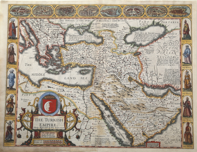
Beautiful colored 'carte-à-figure' of the Turkish Empire by John Speed. One of the most decorative maps of Ottoman Empire issued in the 17th Century. The first map of the region published in England, decorated with 8 Turkish town plan and 10 costumed figures and a large cartouche.
This splendid map covers the region from Greece across the Middle East to include Persia and Arabia, the Black and Caspian Seas, and the Red Sea.
Published in the John Speed "A Prospect of the most famous part of the World" - edition of 1676, with Roger Rea's imprint.
The interior is fully engraved with mountains and deserts, numerous towns and villages with the major ones highlighed in original gauche. Along the top are eight birds-eye views of eight important cities including Damascus, Jerusalem, Constantinople, Rhode, Alexandria, Ormus and Famagusta. The title cartouche features the crescent moon and a crown. Along each side are five full portraits of Greek, Egyptian, Assyrian, and Persian men on the left and their wives on the right. With numerous annotations in blank areas giving historical and geographical details.
The date given is the date the plate was engraved; the English text on verso provides a fascinating contemporary description of the region.
The map includes Italy in the northwest, Russian in the north, Tartaria, Persia and Arabia to the east and the northeast corner of Africa, much of which was controlled by the Ottomans at the time. On the verso in English is a comprehensive (for that time) description of the Ottomans, their origins, their history, traditions and religion.
The so-called Turkish Empire, which was in fact the Ottoman Empire, was one of the mightiest and longest-lasting dynasties in world history. This superpower ruled large areas of the Middle East, Eastern Europe and North Africa for more than 600 years. The head of state was a Sultan who had absolute religious and political authority over his people. Western Europeans generally viewed them as a threat, but many historians regard the Ottoman Empire as a source of great regional stability and security, and of important achievements in the arts, science, religion and culture as well. The Ottomans allowed freedom of worship in occupied territories, and in general governed with a loose rein so long as taxes were paid when due.
This fascinating map includes interesting commentary regarding the various peoples of the regions depicted. For example, reference is made to Prester John, the legendary Nestorian-Christian emperor or king-priest who, according to various reports, was supposed to have ruled in the far east beyond Persia and Armenia. Speed places him in Abyssinia. Eight major cities including Alexandria, Constantinople and Jerusalem are depicted in vignettes along the top of the map, and running down either side are vignettes portraying husbands and wives of different peoples, including Greeks, Egyptians, Assyrians, Arabians and Persians clothed in native raiment. Text inside a small cartouche states that the map is available in Fleet Street and in St. Paul’s Churchyard in London.
John Speed was born 1552 at Farndon in Cheshire. First followed his father trade as a tailor until the age of fifty. His real profession was from early age map making an historian as an amateur, and he focused on this with the help of Sir Fulke Greville. As source for his maps, Speed used material from Saxton and Morden, but he also considered up-to-date material especially for the inset town plans on his maps. The maps have been engraved by Jodocus Hondius in Amsterdam and shipped back to London for printing. The first edition of his Theatre of the Empire of Great Britain came to sale 1610-11 and was re-issued until 1770. In 1627 he published A Prospect of the Most Famous Parts of the World, the first World Atlas produced by an Englishman. Re-issues have been published until 1676.
Copper engraving, with fine later hand colour, in very good condition.
|
John Speed (1552-1629) is the most famous of all English cartographers primarily as a result of The Theatre of the Empire of Great Britaine, the first atlas of the British Isles. The individual maps are the best known and most sought-after of all county maps. They were derived from the best up-to-date sources available; however, Speed did make innovations - introducing town plans, county boundaries, and embellishments such as the coats of arms of local Earls, Dukes, and the Royal Household. The overall effect is to produce very decorative, attractive and informative maps. Speed was also responsible for the first world atlas by an Englishman, The Prospect of the Most Famous Parts of the World (1627). The maps are famed for their borders consisting of local inhabitants in national costume and panoramic vignette views of major cities and towns. An added feature is that regular atlas copies have English text printed on the reverse, giving a charming description of life in the early seventeenth century of the region.
Little is known of Speed's personal life other than that he was born in 1552 the son of a Cheshire tailor who devoted his time to map making. In 1598 he was found a post in the Customs where, with Royal patronage, he was subsidized in map making. Through his work he became a member of such learned societies as the Society of Antiquaries and associated with the likes of William Camden Robert Cotton and William Lambarde. He died in 1629 at the age of seventy-seven.
|
|
John Speed (1552-1629) is the most famous of all English cartographers primarily as a result of The Theatre of the Empire of Great Britaine, the first atlas of the British Isles. The individual maps are the best known and most sought-after of all county maps. They were derived from the best up-to-date sources available; however, Speed did make innovations - introducing town plans, county boundaries, and embellishments such as the coats of arms of local Earls, Dukes, and the Royal Household. The overall effect is to produce very decorative, attractive and informative maps. Speed was also responsible for the first world atlas by an Englishman, The Prospect of the Most Famous Parts of the World (1627). The maps are famed for their borders consisting of local inhabitants in national costume and panoramic vignette views of major cities and towns. An added feature is that regular atlas copies have English text printed on the reverse, giving a charming description of life in the early seventeenth century of the region.
Little is known of Speed's personal life other than that he was born in 1552 the son of a Cheshire tailor who devoted his time to map making. In 1598 he was found a post in the Customs where, with Royal patronage, he was subsidized in map making. Through his work he became a member of such learned societies as the Society of Antiquaries and associated with the likes of William Camden Robert Cotton and William Lambarde. He died in 1629 at the age of seventy-seven.
|