| Reference: | S49630 |
| Author | Johannes JANSSONIUS |
| Year: | 1647 ca. |
| Zone: | Title Page |
| Printed: | Amsterdam |
| Measures: | 250 x 380 mm |
| Reference: | S49630 |
| Author | Johannes JANSSONIUS |
| Year: | 1647 ca. |
| Zone: | Title Page |
| Printed: | Amsterdam |
| Measures: | 250 x 380 mm |
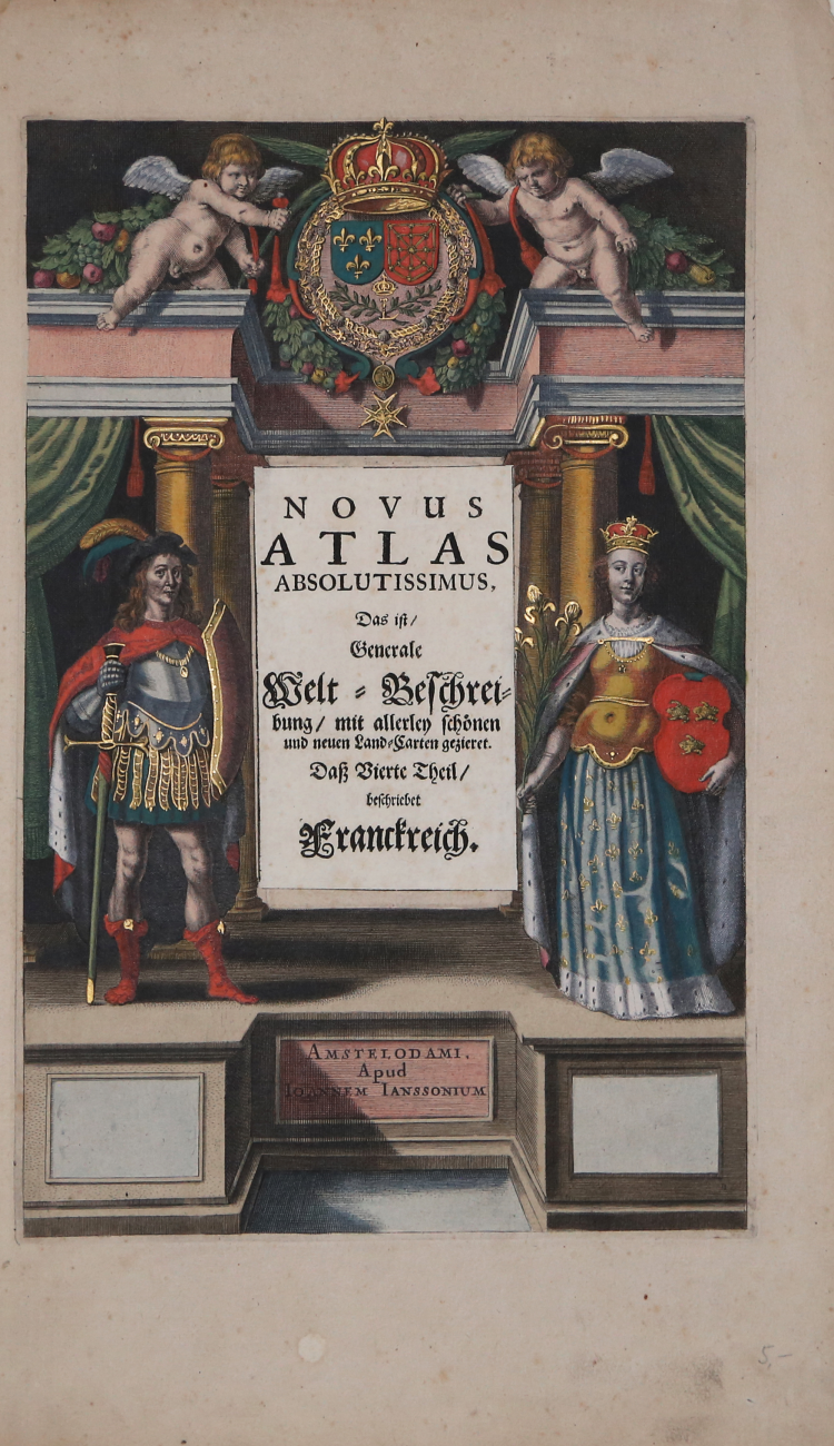
Striking old color example of the title page from Volume IV of Jansson's Atlas Novus, first published in 1636. Marvelous ornated coat of arms and beautifully engraved figures.
A marvelous example in fine old color.
Johannes Janssonius (1588-1664) was the son of a printer, publisher and bookseller from Arnhem with the same name. In 1612 he married Elizabeth Hondius, daughter of Jodocus Hondius I, and in the same year set up his own publishing house in Amsterdam. When Jodocus I died that same year he began helping Hondius’ widow with the continued publication of the Mercator – Hondius atlas. Both Hondius’ widow, Colette, as well as Hondius’ eldest son, Jodocus II, died in 1629; Janssonius therefore joined forces with Hondius’ younger son, Henricus, to revise the Mercator-Hondius atlas, the ‘Atlas Novus’, from 1638.
Johannes JANSSONIUS (1588-1664)
|
Johannes Janssonius, more commonly known to us as Jan Jansson, was born in Arnhem where his father was a bookseller and publisher (Jan Janszoon the Elder). In 1612 he married the daughter of the cartographer and publisher Jodocus Hondius, and then set up in business in Amsterdam as a book publisher. In 1616 he published his first maps of France and Italy and from then onwards he produced a very large number of maps, perhaps not quite rivalling those of the Blaeu family but running a very close second in quantity and quality. From about 1630 to 1638 he was in partnership with his brother-in-law, Henricus Hondius, issuing further editions of the Mercator/Hondius atlases to which his name was added. On the death of Henricus he took over the business, expanding the atlas still further, until eventually he published an 11-volume Atlas Major on a scale similar to Blaeu's Atlas Major.
The first full edition of Jansson's English County Maps was published in 1646 but some years earlier he issued a number of British maps in the Mercator/Hondius/Jansson series of atlases (1636-44); the maps were printed from newly engraved plates and are different from the later 1646 issue and are now rarely seen (see Appendix B for further details).
In general appearance Jansson's maps are very similar to those of Blaeu and, in fact, were often copied from them, but they tend to be more flamboyant and, some think, more decorative.
After Jansson's death his heirs published a number of maps in an Atlas Contractus in 1666 and later still many of the plates of his British maps were acquired by Pieter Schenk and Gerard Valck, who published them again in 1683 as separate maps.
|