
| Reference: | S40080 |
| Author | Nicolas VISSCHER I |
| Year: | 1690 ca. |
| Zone: | Ukraine |
| Printed: | Amsterdam |
| Measures: | 590 x 495 mm |
| Reference: | S40080 |
| Author | Nicolas VISSCHER I |
| Year: | 1690 ca. |
| Zone: | Ukraine |
| Printed: | Amsterdam |
| Measures: | 590 x 495 mm |
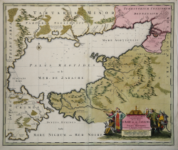
This rare chart of the Sea of Azov and the surrounding area was published around the time of the Azov Campaigns, in which Peter the Great led two Russian military campaigns to capture the important Turkish port city of Azov. The Russians were successful, and were finally able to reach the Sea of Azov and the Black Sea in their attempt at becoming a maritime power. The city of Azov is prominently depicted at top right. The map is handsomely adorned with a title cartouche featuring several Russian figures and deer hunters.
Visscher's map is very rare, having apparently been issued only in a few composite atlases.
This is a later edition by Henrik De Leth, printed in the 18th century.
Nicolaes Visscher I was the son of Claes Jansz. Visscher (1587-1652), a native goldsmith and engraver from Amsterdam who published an atlas in 1634 entitled Germania Inferior, made from copperplates bought from Pieter van den Keere. In 1649 he published another atlas entitled Tabularum Geographicarum Contractarum, containing the same maps as Langenes' Caert-Thresoor. After his father's death, Nicolaes I continued his work, and his first atlas, entitled Atlas Contractus, appeared around 1657. In 1664 he was admitted to the guild of booksellers in Amsterdam and in 1677 was granted a 15-year privilege for the maps he printed.
Very few biographical records remain of Hendrik de Leth, “Kaertverkoper op de Beurssluys te Amsterdam,” as he called himself in 1745. Most likely he was the son of Andries de Leth “kunstverkoper en plaatsnijder”, who lived in Beurssluys “a de Visser”. Andries de Leth died in 1731, and it is very likely that his son succeeded him in the business. Hendrik was born in 1703 and is best known for producing several large maps published in collaboration with Leonard Schenck. Atlases were not his main works; however, he published the Nouvel Atla geographique=Nieuwe Geographische Atlas - a pocket atlas comprising 40 maps, printed undated with imprint Amsterdam by Hendrick de Leth in de Visser - and the Nieuwe Geographische en Historische Atlas, also a small-format collection with 52 maps and same publishing imprint. Hendrik died in 1766; he was probably succeeded by a namesake because under the signature Amsterdam H. de Leth a number of atlases were printed, including the Atlas van de Weereld met de IV gedeeltens of 1788. Hendrik de Leth the younger continued the publication of maps and atlases, perhaps together with another family member, J. de Leth. A number of large-scale maps of considerable size, such as maps of the continents, are well known by Hendrick de Leth; they were sold individually but are occasionally found included in Dutch composte atlases of the time.
Copperplate with fine original colouring, very good conditions.
Nicolas VISSCHER I (1618 - 1679)
|
For nearly a century the members of the Visscher family were important art dealers and map publishers in Amsterdam. The founder of the business, C. J. Visscher, had premises near to those of Pieter van den Keere and Jodocus Hondius whose pupil he may have been. From about 1620 he designed a number of individual maps, including one of the British Isles, but his first atlas consisted of maps printed from plates bought from van den Keere and issued as they stood with some additions of his own, including historical scenes of battles and sieges for which he had a high reputation. Some maps bear the latinized form of the family name: Piscator. After Visscher's death his son and grandson, both of the same name, issued a considerable number of atlases, constantly revised and brought up to date but most of them lacking an index and with varying contents. The widow of Nicholaes Visscher II carried on the business until it finally passed into the hands of Pieter Schenk.
|