| Reference: | S33901 |
| Author | Hessel GERRITSZ |
| Year: | 1613 ca. |
| Zone: | Russia |
| Printed: | Amsterdam |
| Measures: | 575 x 480 mm |
| Reference: | S33901 |
| Author | Hessel GERRITSZ |
| Year: | 1613 ca. |
| Zone: | Russia |
| Printed: | Amsterdam |
| Measures: | 575 x 480 mm |
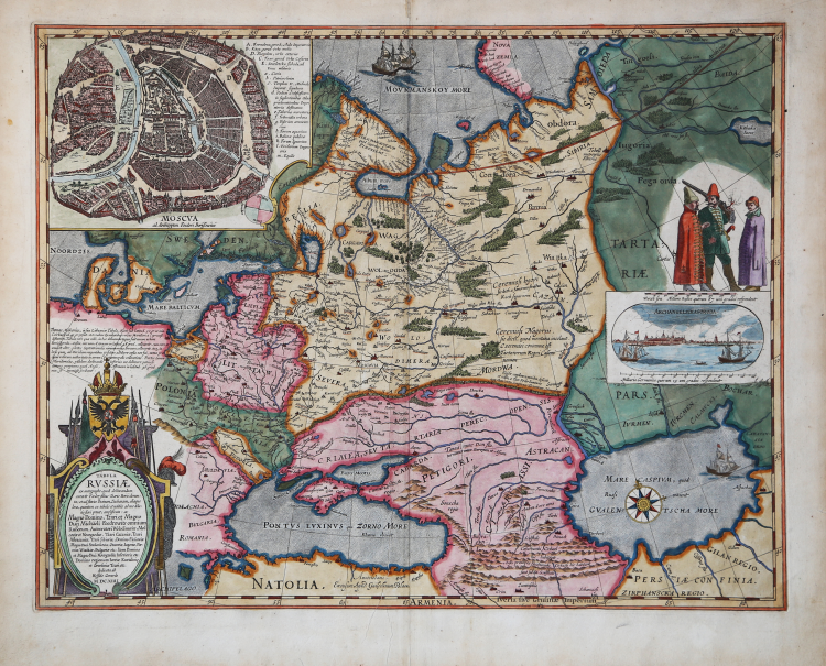
Tabula Russiae ex autographo, quod delineandum curavit Foedor filius Tzaris Boris desumta; et ad fluvios Dwinam, Zuchanam, aliaque loca, quatum ex tabulis et notitiis ad nos delatis fieri potunt, amplificata: ac Magno Domino, Tzari, et Magno Duci Michaeli Foedrowits omnium Rußorum, Autocratori Wolodimeriae, Moscoviae et Novogardiae, Tzari Cazaniae, Tzari Astracaniae, Tzari Siberiae, Domino Plescoviae Magno Duci Smolenscoviae, Otweriae, Iugoriae, Permiae, Wiatkiae, Bulgariae etc: Item Domino et Mogno Duci Novogardiae Inferioris etc: Domino Rgionum Iveriae Kartalinie et Groesiniae Tzari etc: dedicata ab Hesselo Gerardo M.DC.XIIII.
Example of the third state, published by Johannes Blaeu, Amsterdam 1660 ca.
Fine old color example of Hessel Gerritsz's map of Russia, with the large inset of Moscow and plan of Archangelsckagoroda.
Blaeu’s reissue of Hessel Gerritsz’s rare and influential map of Russia. This fine map was compiled from manuscripts brought back from Russia, by Isaac Massa to whom the large inset plan of Moscow is said to be attributed. The map was first issued by Hessel Gerritsz in 1613. Blaeu published it after acquiring the plate after Gerritsz’s death in 1632. This edition has Dutch text on the verso. This superb map has many interesting and decorative features, including; a detailed inset plan of Moscow, complete with a seventeen letter key of prominent public buildings and churches; a compass rose and a galleon in the Caspian Sea; a small inset view of the northerly port of Archangel; three Russian men in local dress and a magnificent map title and dedication.
The map has a very important place in the history of Russia. As mentioned in the cartouche, the draft was made personally by the Czar of Russia Feodor II Godunov (1589 – 1605), while he was only in his mid-teens. Feodor, a son of Czar Boris Godunov, was a highly intelligent and promising young ruler of Russia, known for his fine education. He was murdered by his opponents in 1605 when he was only 16 years old.
Bibliografia
V.d.Krogt, Atlantes Neerlandici, Vol.2, 2:131.1; Schilder, MCN IV, S. 78f.; Bagrow/C. S. 58 u. vgl. S. 52ff.; Koeman II, 1800:2.2.
|
Gerritsz was apprenticed to W. J. Blaeu as an engraver before starting in business on his own account.
He worked closely with Petrus Plancius and his merit may be judged by the fact that he was appointed Cartographer to the Dutch East India Company in preference to Blaeu and subsequently held the same position in a newly formed West India Company. With the new company he came into touch with Johannes de Laet for whom he prepared a number of new maps of America in the latter's Nieuwe Wereldt published in 1625.
His most important early work was a chart showing Henry Hudson's discoveries in his voyage of 1610-11: it is the first to give an outline of Hudson's Bay and indicates Hudson's belief that he had found a way to the North West Passage.
|
|
Gerritsz was apprenticed to W. J. Blaeu as an engraver before starting in business on his own account.
He worked closely with Petrus Plancius and his merit may be judged by the fact that he was appointed Cartographer to the Dutch East India Company in preference to Blaeu and subsequently held the same position in a newly formed West India Company. With the new company he came into touch with Johannes de Laet for whom he prepared a number of new maps of America in the latter's Nieuwe Wereldt published in 1625.
His most important early work was a chart showing Henry Hudson's discoveries in his voyage of 1610-11: it is the first to give an outline of Hudson's Bay and indicates Hudson's belief that he had found a way to the North West Passage.
|