| Reference: | MS1642 |
| Author | Dépôt des cartes et plans de la Marine |
| Year: | 1791 |
| Zone: | Azores |
| Printed: | Paris |
| Measures: | 860 x 570 mm |
| Reference: | MS1642 |
| Author | Dépôt des cartes et plans de la Marine |
| Year: | 1791 |
| Zone: | Azores |
| Printed: | Paris |
| Measures: | 860 x 570 mm |
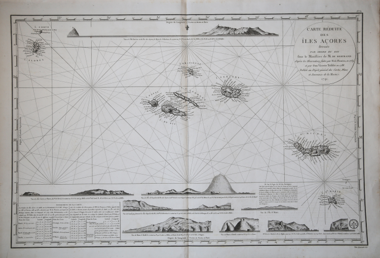
Carte Reduite des Iles Acores dressee Par Ordre du Ministre de la Marine Pour le Service des Vaisseux Francais, d'apres les Observations faites par M. de Fleurieu, en 1769 et par Don Vicente Tofiño en 1788/ Publiee au Depot general des Cartes, Plans et Journaux de la Marine. 1791.
A well engraved and highly detailed chart . It shows soundings, anchorage's, channels, shoals, navigational sightings.
Engraved by Petit, engraver for the Depot Générale de la marine. To the left insets with coastal profiles.
The main source for the chart's topography and place names is Vincente Tofiño de San Miguel's 1788 Carta esferica de las Islas de los Azores o Terceras, whose detail appears for the most part to be identical to this. A bank between the islands of Tercera and St. Michael has been added, as well as a small island southeast of the Formigues islands spotted by French mariners in 1788. This chart employs rhumb lines where the Tofiño uses latitude & longitude lines. The most significant visual difference between the Tofiño and the Depot are the latter chart's nine beautifully engraved coastal views. These all are far superior to those found on the 1755 Bellin, and show the benefit of more recent survey.
A beautiful chart in fine condition.
Dépôt des cartes et plans de la Marine
|
The Dépôt de la Marine, known more formally as the Dépôt des cartes et plans de la Marine, was the central charting institution of France. The centralization of hydrography in France began in earnest when Jean-Baptiste Colbert became First Minister of France in 1661. Under his watch, the first Royal School of Hydrography began operating, as did the first survey of France’s coasts (1670-1689). In 1680, Colbert consolidated various collections of charts and memoirs into a single assemblage, forming the core of sources for what would become the Dépôt.
The Dépôt itself began as the central deposit of charts for the French Navy. In 1720, the Navy consolidated its collection with those government materials covering the colonies, creating a single large repository of navigation. By 1737, the Dépôt was creating its own original charts and, from 1750, they participated in scientific expeditions to determine the accurate calculation of longitude.
In 1773, the Dépôt received a monopoly over the composition, production, and distribution of navigational materials, solidifying their place as the main producer of geographic knowledge in France. Dépôt-approved charts were distributed to official warehouses in port cities and sold by authorized merchants. The charts were of the highest quality, as many of France’s premier mapmakers worked at the Dépôt in the eighteenth century, including Philippe Bauche, Jacques-Nicolas Bellin, Rigobert Bonne, Jean Nicolas Buache, and Charles-François Beautemps-Beaupré.
The Dépôt continued to operate until 1886, when it became the Naval Hydrographic Service. In 1971, it changed names again, this time to the Naval and Oceanographic Service (SHOM). Although its name has changed, its purpose is largely the same, to provide high quality cartographic and scientific information to the France’s Navy and merchant marine.
|