| Reference: | S48663 |
| Author | Henri Abraham CHATELAIN |
| Year: | 1708 ca. |
| Zone: | Paraguay, Chile |
| Printed: | Amsterdam |
| Measures: | 530 x 410 mm |
| Reference: | S48663 |
| Author | Henri Abraham CHATELAIN |
| Year: | 1708 ca. |
| Zone: | Paraguay, Chile |
| Printed: | Amsterdam |
| Measures: | 530 x 410 mm |
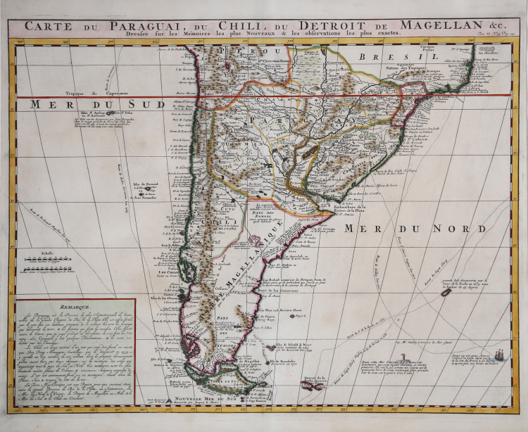
Superb, large map of the southern half of South America, filled with information concerning various discoveries, expeditions, and colonization.
In the Pacific, the routes of Magellan, Schouten & Le Maire, Mendana & Gallego, Sarmiento and Drake are shown. Large keys provide information about the political divisions and the Capitanias of Brazil. Extensive notations exhibit the extent of exploration in the interior.
The map appeared in Chatelain's monumental Atlas Historique, published in Amsterdam between 1705 and 1720.
Henri Abraham Chatelain (1684 - 1743) was a Huguenot pastor of Parisian origins. He is best known as a Dutch cartographer and more specifically for his cartographic contribution in the seminal seven volume Atlas Historique, published in Amsterdam between 1705 and 1720. Innovative for its time, the Atlas Historique combined fine engraving and artwork with scholarly studies of geography, history, ethnology, heraldry, and cosmography. Some scholarships suggest that the Atlas Historique was not exclusively compiled by Henri Chatelain, as is commonly believed, but rather was a family enterprise involving Henri, his father Zacharie and his brother, also Zacharie.
Copper engraving, fine later hand colour, in excellent condition. Higly decorative.
Henri Abraham CHATELAIN (1684 - 1743)
|
Henri Abraham Chatelain (1684 - 1743) was a Huguenot pastor of Parisian origins. He is best known as a Dutch cartographer and more specifically for his cartographic contribution in the seminal seven volume Atlas Historique, published in Amsterdam between 1705 and 1720. Innovative for its time, the Atlas Historique combined fine engraving and artwork with scholarly studies of geography, history, ethnology, heraldry, and cosmography. Some scholarship suggests that the Atlas Historique was not exclusively compiled by Henri Chatelain, as is commonly believed, but rather was a family enterprise involving Henri, his father Zacharie and his brother, also Zacharie. The Atlas Historique published by Chatelain was part of a major work of its time, an encyclopaedia in seven volumes including geography as one of its main subjectes. The text was by Nicholas Gueudeville and the maps by Chatelain. The Atlas included one of the finest maps of America (4 sheets) surrounded by vignettes and decorative insets.
1705-20 Atlas Historique:Amsterdam (maps by Chatelain based on G.Delisle)
Further issues to 1739
|