| Reference: | S49969 |
| Author | Frederick de WIT |
| Year: | 1745 |
| Zone: | Pacific Ocean |
| Printed: | Amsterdam |
| Measures: | 560 x 490 mm |
| Reference: | S49969 |
| Author | Frederick de WIT |
| Year: | 1745 |
| Zone: | Pacific Ocean |
| Printed: | Amsterdam |
| Measures: | 560 x 490 mm |
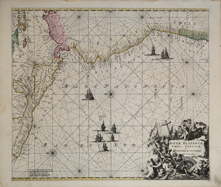
Nice example of this sea chart of the western coastlines of South and Central America, produced by Frederick De Wit in 1675 and later issued in the 18th Century by Renard (1715) and Ottens (1745).
Example of the third state with Ottens’ imprint.
The map covers the Pacific Coast from Xalisco, Mexico, to Puerta Bairres and Rio Cachapool in Chile, covering over two thirds of the Chilean Coast. In the Caribbean, all of the Yucatan and parts of Cuba and Hispaniola are shown, along with all of Jamaica and the Caymans. Nice detail throughout Central America. Columbia is shown in its entirety, along with a small piece of Venezuela. Includes well over 100 place names in classic Portolano style, along with gorgeous allegorical cartouche, 8 sailing ships and two compass roses.
Etching, fine original hand colouring, very good condition.
Frederick de Wit (c. 1630–1706) was a cartographer and publisher originally from Gouda. He moved to Amsterdam in 1648, studying under the Blaeu family, and in 1654 he began his own business, opening a printing shop under the name “The Three Crabs” later changed to “The White Chart”. In 1660 he published his world map, Nova Totius Terrarum Orbis Tabula, produced both as a wall map and as a folio atlas (see Shirley, The Mapping of the World, no. 444). Two years later he began printing atlases that were assembled primarily to order, some of which included over 150 maps. After marrying Maria van der Way, a native of Amsterdam, de Wit obtained citizen privileges and became a member of the city guild of Saint Luke in 1664. In 1675, he published his sumptuous nautical atlas, Orbis Maritimus ofte Zee Atlas, also known for its elaborate decoration. In 1695, he published a book of city views of the Netherlands, Perfekte aftekeningen der steden van del XVII Nederlandsche provincien. After de Wit's death, his widow, Maria, continued the business until 1710. Their son, Franciscus, was a fish merchant and had no interest in the map shop. The printing shop was then sold at auction, and most of the plates were purchased by Pieter Mortier. The 27 plates from his 1675 nautical atlas were later sold at auction in 1710 to the Amsterdam printer and bookseller Louis Renard, who published them under his own name with some modifications in 1715.
Joachim Ottens (1663–1719) and his sons Renier and Joshua (1698–1750 and 1704–1765) were prominent Dutch booksellers and map publishers from around 1680 to 1790. Joachim, the founder of the firm, initially worked as an engraver for Frederick de Wit. In 1711, Joachim started his own business, but died a few years later, and his sons Renier and Joshua took over the printing business, leading it to its most prolific period. Cartographic production concentrated in the years between 1720 and 1750, when Reiner and Joshua printed massive collections of maps, some of which ran to as many as 15 volumes. They included virtually all the maps available at the printer, a sort of "complete works" assembled to order, usually with exquisite colorization of the maps. In addition to these specially prepared collections, there are also known single-volume atlases—with ever-changing content—and some pocket atlases.
Frederick de WIT (1630 - 1706)
|
De Wit was one of the most prominent and successful map engravers and publishers in Amsterdam in the period following the decline of the Blaeu and Jansson establishments, from which he acquired many copper plates when they were dispersed at auction. His output covered most aspects of map making: sea charts, world atlases, an atlas of the Netherlands, 'town books' covering plans of towns and cities in the Netherlands and Europe, and wall maps. His work, notable for the beauty of the engraving and colouring, was very popular and editions were issued many years after his death by Pieter Mortier and Covens and Mortier.
|