
| Reference: | S49968 |
| Author | Johannes VAN KEULEN |
| Year: | 1682 ca. |
| Zone: | Brazil |
| Printed: | Amsterdam |
| Measures: | 590 x 515 mm |
| Reference: | S49968 |
| Author | Johannes VAN KEULEN |
| Year: | 1682 ca. |
| Zone: | Brazil |
| Printed: | Amsterdam |
| Measures: | 590 x 515 mm |
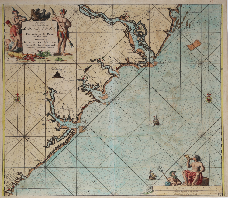
This superb Van Keulen sea chart features the coast of Brazil starting just north of the estuary of the São Francisco River, and continuing down the coast to the estuary of the Ponica River. Numerous estuaries are found along the coast, including that of the Vaza-Barris River, which is only 280 miles long but whose drainage basin is 5,600 square miles. At its mouth is the city of São Cristóvão. Founded in 1590, it is the fourth oldest European settlement in Brazil. The city is noted for its historic city square, São Francisco Square, and numerous early colonial-period buildings. Salvador, noted for its splendid beaches is also in this region of the country. The many estuaries depicted illustrate the relative ease with which early explorers could go inland from the Atlantic. Shoals along the coast are delineated.
Numerous settlements are depicted, as are fortresses and one silver mine called (at that time) Tapiana. The borders of the map are graduated for latitude, and bar scales are in Dutch miles, Spanish miles and English and French miles (actually leagues). An elaborate decorative title cartouche featuring indigenous peoples and wildlife, frigates at full sail, a lovely compass rose and a vignette featuring Poseidon and an allegorical figure based on Triton all embellish the map.
From: De Nieuwe Groote Lichtende Zee-Fakkel, ... Amsterdam, J. van Keulen, 1697-1709.
Johannes van Keulen (1654-1711) was a Dutch publisher. He was said to have produced âthe largest and finest marine atlases in Holland.â (Koeman) He received a privelege from the States General of Holland and West Friesland in order to printe maritame atlases and shipping guides. The privilege was to protect his printed material from illegal reproduction. He named his printing firm, In de Gekroonde Lootsman, which grew to be one of the most successful Amsterdam publishing firms. He collaborated with other cartographers including Claes Janszoon Vooght and Johannes van Luyken. --- Keulen's first atlas, entitled "Zee Atlas", contained only 40 charts. By 1695 his atlas would have 160 charts. His son, Gerard, took over publication in 1704 and expanded the atlas to 185 charts by 1709. --- Gerard van Keulen (1678-1727) was a skilled engraver, mathematician, and chart-maker. He was appointed Hydrographer to the Dutch East India Company in 1714. The van Keulen publishing firm operated continuously from 1678 to 1885 with three generations of the family active in the firm.
Bibliografia
Koeman - Keu (152).
Johannes VAN KEULEN (1654 - 1715)
|
The Van Keulen dynasty of publishers, printers, booksellers, and cartographers produced the most comprehensive and up-to-date Dutch nautical atlases. Johannes van Keulen (1654–1715) founded a book and instrument business in Amsterdam in 1678 and in 1680 obtained the privilege of printing nautical guides and atlases from Holland and West Friesland. His first major work was the Nieuwe Lichtende Zee-Fakkel, illustrated by Jan Luyken, with maps drawn by Claes Jansz Vooght; five volumes were published between 1681 and 1684. Van Keulen also produced a Zee-Atlas ofte Water-werelt. The Van Keulen family continued to operate for nearly two centuries; Gerard (1678 - 1726) produced new editions of his father's works, numerous manuscript maps, and was appointed hydrographer to the Dutch East India Company (VOC) in 1706; his son Jan II van Keulen (1704 - 1770) took over the business in 1726 and published a new edition of the Asiatic volume of the Zee-Atlas; he was appointed cartographer to the VOC in 1743. After Jan II's death, his sons Cornelis Buijs and Gerard Hulst van Keulen ran the family business. Gerard (1733 - 1801) added a further volume to the Zee-Fakkel containing East India material derived from the VOC. Gerard, in addition to publishing the first nautical almanac in Dutch in 1788, was one of the three original members of the commission established by the Dutch government in 1787 to solve the problem of finding longitude at sea. Gerard's son, Jan III, was the last van Keulen to run the company.
|