
| Reference: | S48765 |
| Author | Johannes VAN KEULEN |
| Year: | 1680 ca. |
| Zone: | Brazil |
| Printed: | Amsterdam |
| Measures: | 585 x 515 mm |
| Reference: | S48765 |
| Author | Johannes VAN KEULEN |
| Year: | 1680 ca. |
| Zone: | Brazil |
| Printed: | Amsterdam |
| Measures: | 585 x 515 mm |
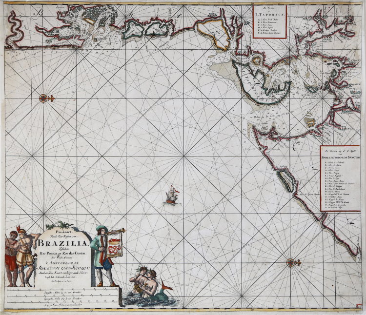
Beautiful nautical chart of the Brazilian Atlantic coastline, first published in the 1680 edition of De Groote Nieuwe Vermeerderde Zee-Atlas ofte Water-werelt (see Koeman, AN, vol. IV, p. 282), and replicated in the same year in the French edition, entitled Le Grand Nouvel Atlas de la Mer (Koeman, Keu 2).
Borders graduated for latitude. Bar scales in Dutch miles, Spanish miles and English and French miles. Shows the location of the Tapiana silver mine and numerous settlements.
The Van Keulen dynasty of publishers, book merchant printers and cartographers produced the most complete and up-to-date Dutch nautical atlases. Johannes van Keulen (1654 - 1715) established a book and instrument sales business in Amsterdam in 1678 and in 1680 was granted the privilege by Holland and West Friesland to print nautical guides and atlases. His first major work was the Nieuwe Lichtende Zee-Fakkel, illustrated by Jan Luyken, with maps drawn by Claes Jansz Vooght; five volumes were published between 1681 and 1684. Van Keulen also produced a Zee-Atlas ofte Water-werelt. The Van Keulen business continued for nearly two centuries; Gerard (1678 - 1726) produced new editions of his father's works, numerous manuscript maps, and in 1706 was appointed hydrographer of the Dutch East India Company (VOC); his son Jan II van Keulen (1704 - 1770) took over the business in 1726 and published a new edition of the Asian volume of the Zee-Atlas; he was appointed cartographer of the VOC in 1743.
Etching, finely hand-colored, restorations to upper corners, otherwise in very good condition.
Bibliografia
Koeman, Bibliography of terrestrial, maritime and celestial atlases and pilot books, published in the Netherlands up to 1880, 152.
Johannes VAN KEULEN (1654 - 1715)
|
The Van Keulen dynasty of publishers, printers, booksellers, and cartographers produced the most comprehensive and up-to-date Dutch nautical atlases. Johannes van Keulen (1654–1715) founded a book and instrument business in Amsterdam in 1678 and in 1680 obtained the privilege of printing nautical guides and atlases from Holland and West Friesland. His first major work was the Nieuwe Lichtende Zee-Fakkel, illustrated by Jan Luyken, with maps drawn by Claes Jansz Vooght; five volumes were published between 1681 and 1684. Van Keulen also produced a Zee-Atlas ofte Water-werelt. The Van Keulen family continued to operate for nearly two centuries; Gerard (1678 - 1726) produced new editions of his father's works, numerous manuscript maps, and was appointed hydrographer to the Dutch East India Company (VOC) in 1706; his son Jan II van Keulen (1704 - 1770) took over the business in 1726 and published a new edition of the Asiatic volume of the Zee-Atlas; he was appointed cartographer to the VOC in 1743. After Jan II's death, his sons Cornelis Buijs and Gerard Hulst van Keulen ran the family business. Gerard (1733 - 1801) added a further volume to the Zee-Fakkel containing East India material derived from the VOC. Gerard, in addition to publishing the first nautical almanac in Dutch in 1788, was one of the three original members of the commission established by the Dutch government in 1787 to solve the problem of finding longitude at sea. Gerard's son, Jan III, was the last van Keulen to run the company.
|