| Reference: | s34948 |
| Author | Henrick SCHERER |
| Year: | 1703 ca. |
| Zone: | Southern Africa |
| Printed: | Munich |
| Measures: | 350 x 238 mm |
| Reference: | s34948 |
| Author | Henrick SCHERER |
| Year: | 1703 ca. |
| Zone: | Southern Africa |
| Printed: | Munich |
| Measures: | 350 x 238 mm |
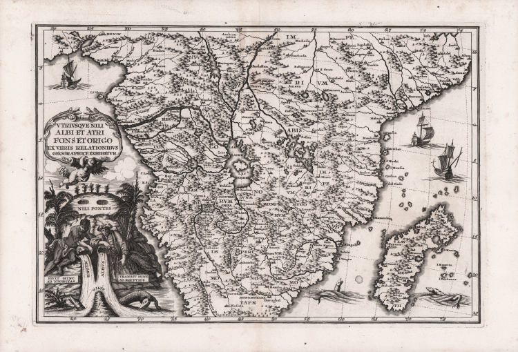
Decorative map of central and southern Africa and Madagascar by Heinrich Scherer (1628-1704) for his Atlas Novus exhibens orbem terraguem per naturae opera, historiae navae acveterus monumenta, artistique geographicae leges et praecepta...published in eight volumes from 1702-1710 in Munich.
Scherer, a devout Jesuit, produced this geographical compendium to depict the Catholic hierarchy and the spread of Jesuit missions throughout the world.
The map is full of the spurious geography of the period with large lakes, rivers and mountains. The Nile is prominently featured with its twin tributaries coming out of Lake Zaire and Lake Zaflan to the east.
The decorative title cartouche continues the theme with two river gods (represented by a Nigerian and an Egyptian) symbolizing the Niger and Nile Rivers, with crocodiles emerging from the waters.
The map is further embellished with sailing ships and sea monsters.
Copper engraving, in very good condition.
|
Shirley (BL Atlases) T.SHER-1a #22.
|
Henrick SCHERER (Dilingen 1628 - Monaco 1704)
|
Heinrich Scherer was a devout Jesuit, and professor of mathematics at Munich. His 'Atlas Novus' contained maps of all other parts which showed the spread of Catholicism and Jesuit missions.
|
|
Shirley (BL Atlases) T.SHER-1a #22.
|
Henrick SCHERER (Dilingen 1628 - Monaco 1704)
|
Heinrich Scherer was a devout Jesuit, and professor of mathematics at Munich. His 'Atlas Novus' contained maps of all other parts which showed the spread of Catholicism and Jesuit missions.
|