| Reference: | CO-362 |
| Author | Jean Matal METELLUS |
| Year: | 1579 ca. |
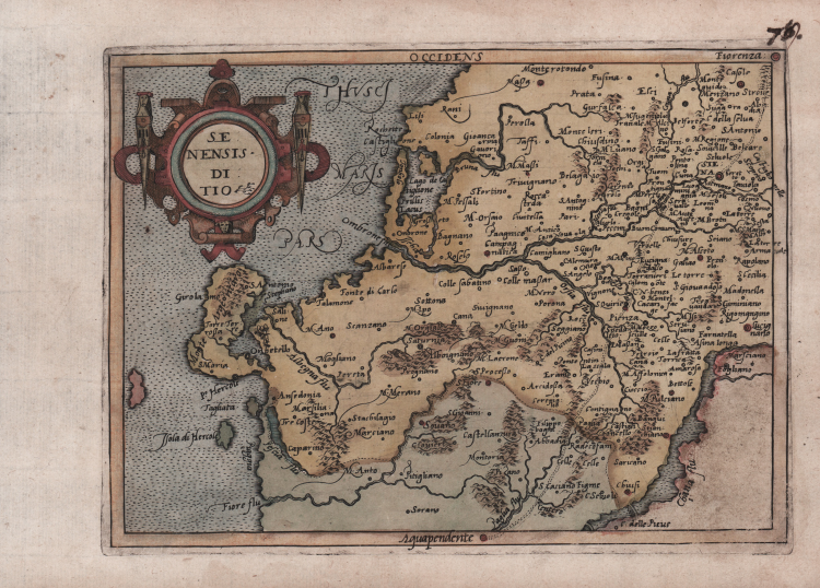
| Zone: | Siena |
| Printed: | Cologne |
| Measures: | 200 x 150 mm |
| Reference: | CO-362 |
| Author | Jean Matal METELLUS |
| Year: | 1579 ca. |
| Zone: | Siena |
| Printed: | Cologne |
| Measures: | 200 x 150 mm |
Map taken from the very rare Itinerarium Europae Provinciae published in Cologne between 1579 and 1588.
First state example, before the number. Based on the map of Latium published by Abraham Ortelius in the 1570 Theatrum Orbis Terrarum, itself a reduction of the SENAE ET ADIACENTIUM LOCORUM DESCRIPTIO (Venezia, 1570 circa) engraved by Giacomo Fanco and printed by Claudio Duchetti.
Also known as Itinerarium Orbis Christiani, this atlas was published anonymously because of the political and religious problems that characterized the historical period, as was often the case at the time to escape Catholic persecution against Protestants.
The work is part of the atlases published by the so-called Cartographic School of Cologne, which lasted for about half a century (c. 1570-1610), and consisted mainly of Flemish and Dutch refugees, among them Matthaeus Quad himself and Frans Hogenberg, who was its founder.
The maps are attributed some to Jan Matal and others to Michael von Eitzing.
Jan Matal or Metellus, French by birth and active in Louvaine and Cologne, where he took refuge precisely to escape persecution by Catholic rulers and where he died in 1597. He was among the leading cartographers of the time and, along with Quad and Hogenberg himself, the leading exponent of the Cologne school. Some of Matal's maps are later included in later posthumous publications and bear the text on the verso.
Cartographically, the maps are a derivation of and based on maps first published in Antwerp by Abraham Ortelius in 1570; the engravings of the maps, however, are attributed to Frans Hogenberg. The great rarity of the works published in Cologne, contributes to the appeal of this important map, a cornerstone of every cartographic collection. Each Atlas turns out to be different from the other, as extensively documented in Peter H. Meurer's essay, Atlantes Colonienses, Die Kolner Schule der Atlaskartographie 1570-1610. Our example corresponds to the collection described as IOC 8.
Copperplate engraving, magnificent contemporary coloring, in good condition.
Bibliografia
Peter H. Meurer, Atlantes Colonienses, Die Kolner Schule der Atlaskartographie 1570-1610, pp. 138-139, IOC 8.
Jean Matal METELLUS (1520 – 1597)
|
Metellus is an obscure figure about whom little is known except that he was born in Louvain ,later being heard of in Cologne where he was probably a publisher as well as cartographer. He compiled a set of maps of America (with a World Map) very similar to those of Cornelis van Wytfliet with which they are often confused . The maps by Metellus are much rarer than those of Wytfliet.
1598 Geographische und Historische Beschreibung der uberauss grossen Landschafft America by Josè D’Acosta:published by Johann Christoffel,
Cologne:20 maps
1600 re-issued
|