| Reference: | A53565 |
| Author | Pierre MORTIER |
| Year: | 1704 ca. |
| Zone: | Siena |
| Printed: | Amsterdam |
| Measures: | 528 x 415 mm |
| Reference: | A53565 |
| Author | Pierre MORTIER |
| Year: | 1704 ca. |
| Zone: | Siena |
| Printed: | Amsterdam |
| Measures: | 528 x 415 mm |
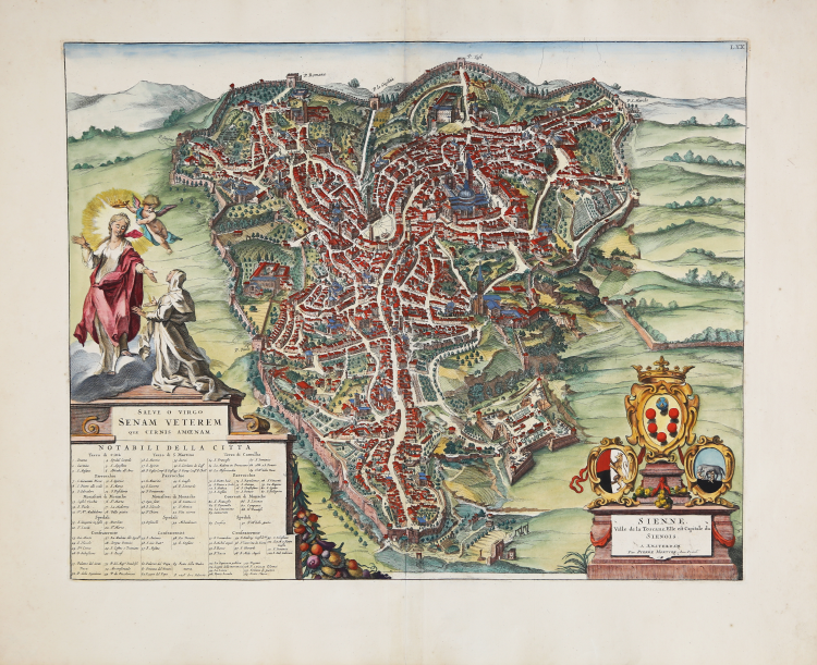
The title SIENNE. Ville de la Toscana, Elle est capitale du Siennoise is engraved on a cippus in the lower right corner; below the title is the publisher's address: A Amsterdam par Pierre Mortier Avec Privil.ge; on a plaque in the lower left corner: SALVE O VIRGO SENAM VETEREM QUE CERNIS AMOENAM; below: NOTABILI DELLA CITTA' with one hundred and ten toponymic references. Around the city are the names of the gates. Clockwise from top: P. Romana; P. la Giustizia; P. Tufi; P. S. Marcho; P. Fonte Blanda; P. Camullia; P. Ovile; P. Sviene. At the top right, outside the frame: LXX.
Map taken from the first volume of the Nouveau Theatre de l'Italie published in Amsterdam in 1704/5 and in 1724, as an integration to the project of Johannes Baleu, started in 1663, of the great town book, lacking the maps of most of the northern part of Italy.
Blaeu, during his long editorial activity published three volumes on Italian cities. In 1663 the first three, divided into the State of the Church, Rome and the Kingdom of Naples and Sicily. At his death his heirs gave birth to two more volumes dated 1682 focused on the cities of Piedmont and Savoy, then reprinted by other publishers in 1693 and 1697. The French Pierre Mortier publishes a reprint in 1704/5, entitled Nouveau Theatre de l'Italie. The work is in four volumes and includes the plates of Blaeu, retouched and modified in small part, supplemented by the addition of several new maps of his own design, depicting the cities of the northern part of the peninsula, enclosed in the first volume of the work. Mortier's atlas was published with Latin, French and Dutch texts.
The peculiarity that differentiates the two editions of Blaeu and Mortier is represented by the fact that the text is not on the back of the single map (which is therefore white in the back), but is at the beginning of each volume. The great success of the work gave rise to a further reprint, virtually identical, edited by R. Alberts and published in 1724/5.
“Non ci sono indicazioni che l'immagine edita da Pierre Mortier appartenesse alle tavole già incise da Joan Blaeu prima dell'incendio della stamperia. Le grandi dimensioni e l'eccellente qualità grafica non sono accompagnate da nessun tratto originale rispetto alla Vanni- De Jode. In basso a destra sopra il titolo si vedono lo stemma mediceo e i due stemmi senesi, come erano apparsi in Merian e Jansson. A sinistra sopra la tabella delle cose notabili è rappresentata santa Caterina, inginocchiata al cospetto della Vergine alla quale chiede protezione per la città di Siena. La pianta urbana riprende in modo pressoché fedele il rilievo di Francesco Vanni; il punto di vista moto rialzato descrive interamente la forma della città, orientata anche in questo caso in modo da presentare l'area settentrionale verso il basso. Fuori dalle mura, antistante Porta Camollia, si vede l'arco trionfale innalzato in occasione dell'ingresso a Siena di Cosimo I de Medici nel 1560. Manca il Torrazzo, demolito nel 1580, ma è rappresentata la colonna eretta nel 1492 per commemorare l'incontro tra Federigo III ed Eleonora di Portogallo patrocinato da Pio II; in posizione più esterna si vede una fortificazione identificabile nell'Antiporto. A destra fuori dalle mura si distingue la zona della Lizza e la fortezza di Santa Barbara, costruita a partire dal 1561 e ultimata nel 1580. Il tessuto urbano compreso entro il perimetro murario si compone di edifici di diverso tipo e presenta ampi spazi non edificati; è data ampia visibilità alla rete viaria, accentuando in particolare l'asse che taglia in senso longitudinale la città e che da Porta Camollia si dirama verso Porta Tufi (in alto a destra) e Porta Romana (in alto a sinistra). Tra gli edifici riconoscibili si distingue in basso a destra la chiesa di san Domenico e più in alto la Cattedrale di Santa Maria Assunta. In alto a destra si vede la Chiesa del Carmine, priva del campanile distrutto nella seconda metà del XVI secolo e ricostruito solo nei primi anni del XVII secolo. In alto a destra, in prossimità di Porta Tufi si vede la Chiesa di Sant'Agostino, ancora affiancata dal campanile romanico che crollerà nell'incendio del 1747. In alto a sinistra, in prossimità di Porta Romana è visibile il complesso di Santa Maria dei Servi; più in basso si distingue la chiesa di santo Spirito, sormontata dalla grande cupola cinquecentesca. In prossimità di Porta Ovile, a sinistra, si vedono la chiesa e il monastero di San Francesco. Al centro della città nel punto di raccordo tra la via dei Banchi di Sopra e la via dei Banchi di Sotto si estende piazza del Campo, dove si affaccia il Palazzo pubblico sormontato dalla torre del Mangia” (cfr. Atlante storico iconografico delle città toscane, http://asict.arte.unipi.it/index.html/scheda_indice.php?loc=Siena&op_s=353&page=5 ).
Copper engraving, fine later hand colour, very good condition.
Bibliografia
Bortolotti, 1982, p.95,99,128,131; Pellegrini, 1986, pp.130-132.
|
Pierre Mortier (January 26, 1661 - February 18, 1711) or Pieter Mortier was a cartographer, engraver, and print seller active in Amsterdam during the later 17th and early 18th centuries. Mortier, then known as Pieter, was born in Leiden. He relocated to Paris from 1681 to 1685, adopting the French name Pierre, which he retained throughout his career. While in France, he developed deep French connections by bringing sophisticated Dutch printing technology and experience to nascent French map publishers such as Guillaume De L'Isle (1675 - 1726), Alexis-Hubert Jaillot (c. 1632 - 1712), and Nicholas de Fer (1646 - 1720). Consequently, much of Mortier's business was built upon issuing embellished high quality editions of contemporary French maps - generally with the permissions of their original authors. In the greater context of global cartography, this was a significant advantage as most Dutch map publishes had, at this point, fallen into the miasma of reprinting their own outdated works. By contrast, the cartographers of France were producing the most accurate and up to date charts anywhere. Mortier's cartographic work culminated in the magnificent nautical atlas, Le Neptune Francois. He was awarded the Privilege, an early form of copyright, in 1690. Upon Pierre's death in 1711 this business was inherited by his widow. In 1721, his son Cornelius Mortier took over the day to day operation of the firm. Cornelius partnered with his brother-in-law Jean Covens to form one of history's great cartographic partnerships - Covens and Mortier - which continued to publish maps and atlases until about 1866.
|
|
Pierre Mortier (January 26, 1661 - February 18, 1711) or Pieter Mortier was a cartographer, engraver, and print seller active in Amsterdam during the later 17th and early 18th centuries. Mortier, then known as Pieter, was born in Leiden. He relocated to Paris from 1681 to 1685, adopting the French name Pierre, which he retained throughout his career. While in France, he developed deep French connections by bringing sophisticated Dutch printing technology and experience to nascent French map publishers such as Guillaume De L'Isle (1675 - 1726), Alexis-Hubert Jaillot (c. 1632 - 1712), and Nicholas de Fer (1646 - 1720). Consequently, much of Mortier's business was built upon issuing embellished high quality editions of contemporary French maps - generally with the permissions of their original authors. In the greater context of global cartography, this was a significant advantage as most Dutch map publishes had, at this point, fallen into the miasma of reprinting their own outdated works. By contrast, the cartographers of France were producing the most accurate and up to date charts anywhere. Mortier's cartographic work culminated in the magnificent nautical atlas, Le Neptune Francois. He was awarded the Privilege, an early form of copyright, in 1690. Upon Pierre's death in 1711 this business was inherited by his widow. In 1721, his son Cornelius Mortier took over the day to day operation of the firm. Cornelius partnered with his brother-in-law Jean Covens to form one of history's great cartographic partnerships - Covens and Mortier - which continued to publish maps and atlases until about 1866.
|