| Reference: | S37911 |
| Author | Istituto Geografico Militare |
| Year: | 1943 |
| Zone: | Lampedusa |
| Printed: | Florence |
| Measures: | 585 x 520 mm |
| Reference: | S37911 |
| Author | Istituto Geografico Militare |
| Year: | 1943 |
| Zone: | Lampedusa |
| Printed: | Florence |
| Measures: | 585 x 520 mm |
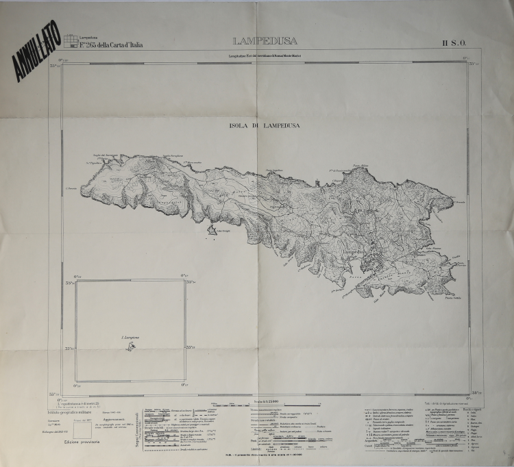
Map of Lampedusa, printed by the Istituto Geografico Militare.
In good condition. Updated to 1943.
The history of the Military Geographical Institute starts from the Office of the General Staff of the Royal Italian Army which, after the Italian unification in 1861 had unified in a single structure, based in Turin, the original Ufficio del Corpo di Stato Maggiore del Regno Sardo, Ufficio Topografico Toscano and the Reale Officio Topografico Napoletano.. The office was then moved to Florence in 1865, at the same time as the Tuscan city was appointed capital of Italy, a city which is still the seat of the Institute today. With the Italian unification, it was recognized the need for the nation to be equipped with a unitary national cartography, the Government of the time entrusted in 1872, with a special law, this task to the Military Topographical Institute, created by the transformation of the military corps. This institute, renamed Istituto Geografico Militare in 1882, surveyed the territory of the State forming the new Carta Topografica d’Italia, at a scale of 1:100,000. This topographical work, largely carried out using the praetorian tablet, took over 30 years.
|
The Istituto Geografico Militare (IGM) is an institute that carries out the functions of cartographic body of the Italian State, according to the law n. 68 of February 2, 1960, dealing with the cartography of the State through a remarkable equipment that makes it one of the most advanced in Italy. It carries out work in geodesy, topography and cartography and on staff there is also a school called Scuola Superiore di Scienze Geografiche (SSSG). Since October 1, 2014, following the suppression of the Army Military Command of Tuscany, it has absorbed its tasks and personnel. It is headquartered in Florence in Via Cesare Battisti occupying a good part of the former convent of Santissima Annunziata.
Its history begins with the Office of the General Staff of the Royal Italian Army which, after the Italian unification in 1861, had unified in a single structure, with its headquarters in Turin, the original Office of the General Staff of the Sardinian Kingdom, the Tuscan Topographical Office and the Royal Topographical Office of Naples. The office was then moved to Florence in 1865, at the same time as the Tuscan city was appointed capital of Italy, a city which is still the seat of the Institute today.
With the Italian unification, it was recognized the need for the State to be equipped with a unitary national cartography, and the Government of the time entrusted in 1872, with a special law, this task to the Military Topographical Institute, created by the transformation of the military corps. This institute, renamed Military Geographical Institute in 1882, surveyed the territory of the State, forming the new Topographical Map of Italy at a scale of 1:100,000. This topographical work, largely carried out using the praetorian tablet, took over 30 years.
During Fascism, the IGM supported the processes of Italianization operated towards the toponymy of the non-Italian languages present on the national territory as well as in the Italian colonies.
|
|
The Istituto Geografico Militare (IGM) is an institute that carries out the functions of cartographic body of the Italian State, according to the law n. 68 of February 2, 1960, dealing with the cartography of the State through a remarkable equipment that makes it one of the most advanced in Italy. It carries out work in geodesy, topography and cartography and on staff there is also a school called Scuola Superiore di Scienze Geografiche (SSSG). Since October 1, 2014, following the suppression of the Army Military Command of Tuscany, it has absorbed its tasks and personnel. It is headquartered in Florence in Via Cesare Battisti occupying a good part of the former convent of Santissima Annunziata.
Its history begins with the Office of the General Staff of the Royal Italian Army which, after the Italian unification in 1861, had unified in a single structure, with its headquarters in Turin, the original Office of the General Staff of the Sardinian Kingdom, the Tuscan Topographical Office and the Royal Topographical Office of Naples. The office was then moved to Florence in 1865, at the same time as the Tuscan city was appointed capital of Italy, a city which is still the seat of the Institute today.
With the Italian unification, it was recognized the need for the State to be equipped with a unitary national cartography, and the Government of the time entrusted in 1872, with a special law, this task to the Military Topographical Institute, created by the transformation of the military corps. This institute, renamed Military Geographical Institute in 1882, surveyed the territory of the State, forming the new Topographical Map of Italy at a scale of 1:100,000. This topographical work, largely carried out using the praetorian tablet, took over 30 years.
During Fascism, the IGM supported the processes of Italianization operated towards the toponymy of the non-Italian languages present on the national territory as well as in the Italian colonies.
|