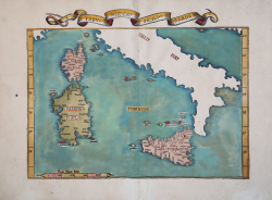
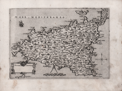
Tabu. Moder. Sicili & Sardi. Laurent FRIES Code: MMS813 Measures: 535 x 375 mm Year: 1522 ca. Printed: Lyon Price €775.00 Quick view View Details
Tabula VII Europae Laurent FRIES Code: S40284 Measures: 555 x 410 mm Year: 1525 Printed: Strasbourg Price €1,200.00 Quick view View Details
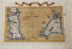
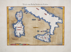
Tabula nova Siciliae, Sardiniae, & Corsicae Laurent FRIES Code: s35047 Measures: 402 x 277 mm Year: 1541 Printed: Vienne Price €1,000.00 Quick view View Details
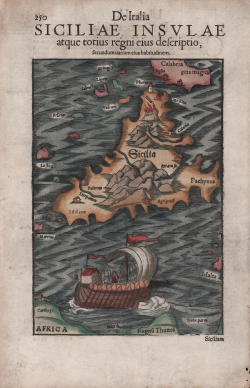
Siciliae Insulae atque totius regni eius descriptio Sebastian Münster Code: S45988 Measures: 200 x 305 mm Year: 1550 ca. Printed: Basle Price €425.00 Quick view View Details
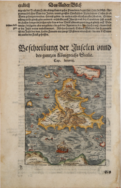
Beschreibung der Inseln und des gantzen Koenigreichs Sicilie Sebastian Münster Code: s38536 Measures: 132 x 161 mm Year: 1564 ca. Printed: Basle Price €225.00 Quick view View Details
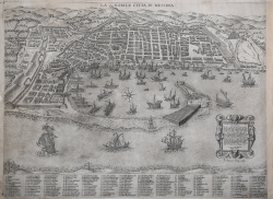
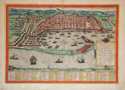
LA NOBILE CITTA DI MESSINA Gaspare Argaria Code: S20004 Measures: 550 x 405 mm Year: 1567 Printed: Rome Price €4,500.00 Quick view View Details
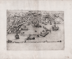
Messina Paolo FORLANI Code: 4098 Measures: 270 x 193 mm Year: 1567 Printed: Venice Price €3,000.00 Quick view View Details
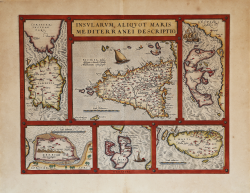
Insularum Aliquot Maris Mediterranei Descriptio Abraham ORTELIUS Code: S299490 Measures: 480 x 364 mm Year: 1570 ca. Printed: Antwerpen Price €1,000.00 Quick view View Details
Sicilia Insula Giovanni Francesco CAMOCIO Code: S30287 Measures: 210 x 145 mm Year: 1571 ca. Printed: Venice Price €2,000.00 Quick view View Details
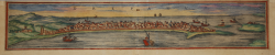
Drepanum Georg BRAUN & Franz HOGENBERG Code: S11236 Measures: 475 x 95 mm Year: 1572 Printed: Antwerpen & Cologne Price €180.00 Quick view View Details
Panhormus, Palermo vulgariter maxima & Metropolitica Siciliae Urbs.. Georg BRAUN & Franz HOGENBERG Code: S46317 Measures: 470 x 145 mm Year: 1572 Printed: Antwerpen & Cologne Price €400.00 Quick view View Details
L'Isle de Sicile Francois de BELLEFOREST Code: S47353 Measures: 370 x 290 mm Year: 1575 Printed: Paris Price €1,100.00 Quick view View Details
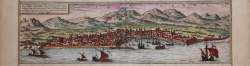
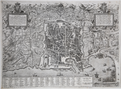
Messana Urbs est Sicilie maxima... Georg BRAUN & Franz HOGENBERG Code: S9928 Measures: 385 x 340 mm Year: 1575 Printed: Antwerpen & Cologne Price €600.00 Quick view View Details
(Siracusa) Francois de BELLEFOREST Code: S38950 Measures: 115 x 105 mm Year: 1575 Printed: Paris Price €125.00 Quick view View Details
Siciliae desciptio Abraham ORTELIUS - Philip GALLE Code: s33947 Measures: 107 x 80 mm Year: 1577 Printed: Antwerpen Price €225.00 Quick view View Details
Palermo Citta principalissima nella Sicilia… Natale BONIFACIO Code: S38006 Measures: 560 x 420 mm Year: 1580 Printed: Rome Price €5,500.00 Quick view View Details
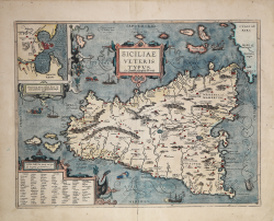
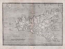
Siciliae Veteris Typus Abraham ORTELIUS Code: S38534 Measures: 490 x 375 mm Year: 1584 ca. Printed: Antwerpen Price €1,000.00 Quick view View Details
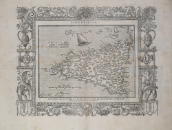
Sicilia Isola Leandro ALBERTI Code: S50071 Measures: 250 x 175 mm Year: 1588 Printed: Venice Price €700.00 Quick view View Details
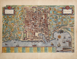
Panormus Corona regis et urbium Sicularum maxima emporium... Georg BRAUN & Franz HOGENBERG Code: S46184 Measures: 530 x 400 mm Year: 1588 Printed: Antwerpen & Cologne Price €900.00 Quick view View Details
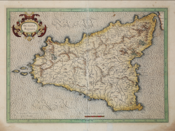
Siciliae Regnum Gerard MERCATOR (Kremer) Code: S19005 Measures: 490 x 345 mm Year: 1589 ca. Printed: Amsterdam Price €850.00 Quick view View Details