
| Reference: | S38534 |
| Author | Jean Baptiste NOLIN |
| Year: | 1701 ca. |
| Zone: | Sicily |
| Printed: | Paris |
| Measures: | 550 x 435 mm |
| Reference: | S38534 |
| Author | Jean Baptiste NOLIN |
| Year: | 1701 ca. |
| Zone: | Sicily |
| Printed: | Paris |
| Measures: | 550 x 435 mm |
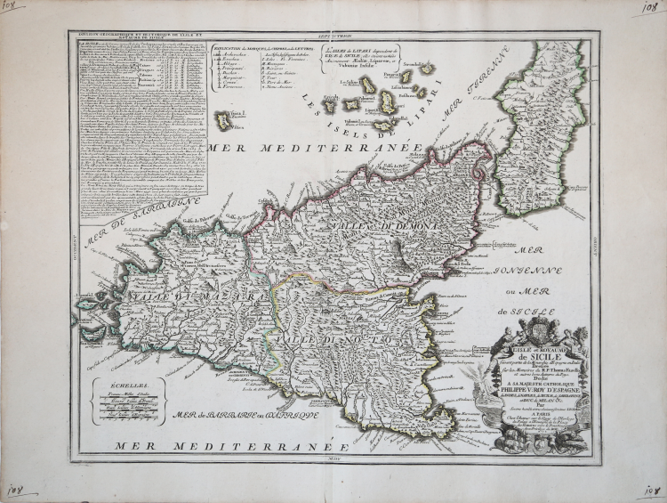
This map of the island, dedicated to Filippo V, takes inspiration from Giacomo Cantelli’s previous work, especially from a toponimical point of view.
The map is made for Le Theatre de la Guerre en Italie, first published in 1701. The work describes in detail the Italian Campaign of 1701-1702 which involved territories of northern Italy with Milan, Cremona, Mantua, Parma, Modena, Bergamo, Crema, Brescia, Verona, Vicenza, Padua, Ferrara and Bologna.
Jean-Baptiste Nolin (ca. 1657-1708) was a French engraver who worked at the turn of the eighteenth century. Initially trained by Francois de Poilly, his artistic skills caught the eye of Vincenzo Coronelli when the latter was working in France. Coronelli encouraged the young Nolin to engrave his own maps, which he began to do.
Whereas Nolin was a skilled engraver, he was not an original geographer.
Nolin, had difficulty in making original maps and, therefore, referred to models of other geographers. Many of his works are based on the engravings of Coronelli - some made in collaboration - and another French cartographer, Jean Nicolas de Tralage called Tillemon.
Another source for his maps was the information that came from the wars in Europe, to which he had access being "geographe du Roy". In 1701 the same Nolin published Le Theatre de la Guerre en Italie, a collection consisting of initial 18 maps that was soon reprinted and updated.
“La carta della Sicilia di Nolin reca la data 1700 e fu pubblicata in più d'una edizione del Théâtre du Monde. La datazione di quest'opera è resa problematica dalla mancanza di date sui frontespizi e dalle numerose raccolte fattizie stampate nel corso del '700 dal figlio, che ne pubblicò una edizione ufficiale nel 1746.
Jean Baptiste Nolin (1657-1708) era figlio di un incisore, ma la svolta della sua vita avvenne quando, nel 1686, Vincenzo Coronelli gli affidò l'incisione dei fusi per un globo celeste e di 28 carte. Questa specializzazione lo portò a cambiare indirizzo, spostandosi dal tradizionale quartiere degli incisori, intorno a Rue Saint Jacques, a la "quai de l'Horloge", ove lavoravano i costruttori di strumenti e i geografi. Le sue opere cartografiche lo portarono ad acquisire, nel 1694, il titolo di geografo del duca di Orleans e, nel 1701, quello di Géographe du Roy. La sua reputazione di geografo fu messa in crisi da un processo per plagio intentatogli da Guillaume Delisle, che lo accusò, nel 1700, di avere copiato integralmente un suo mappamondo. Il processo si concluse solo nel 1706 con la conferma della contraffazione da parte di Nolin. Va tuttavia notato che poiché gran parte della cartografia di quegli anni era cartografia derivata, cioè costruita su fonti non dirette, era abbastanza normale imbattersi in questioni di plagio. La carta della Sicilia di Nolin è una copia abbastanza fedele, anche nel taglio geografico (si veda l'isola di Marettimo parzialmente tagliata dalla cornice), di quella pubblicata da Giacomo Cantelli da Vignola nel 1682.
Un primo abbozzo di edizione del Théâtre si ebbe nel 1693, come risulta da un esemplare, con il titolo in parte mano- scritto, conservato nella Österreichische Nationalbibliothek di Vienna (Wawrik 1982).
Il rame di questa carta venne ben presto modificato e, nel 1702, già risulta inserita una lunga legenda nell'angolo superiore destro sotto il titolo "Division Geographique et Historique de l'Isle et Royaume de Sicile". Inoltre viene del tutto abbandonato l'inquadramento geografico e vengono eliminati anche i segni delle graduazioni lungo la cornice. L'edizione della Sicilia di Nolin con data 1700 è ignota alla bibliografia.” (cfr. Valerio-Spagnolo "Sicilia 1477-1861", p. 350).
Copper engraving, contemporary coloring, in good condition.
Bibliografia:
L. Dufour - A. La Gumina, "Imago Siciliae", p. 166; Valerio-Spagnolo "Sicilia 1477-1861", pp. 350-351, n. 164.
Jean Baptiste NOLIN (circa 1657 - 1708)
|
Jean-Baptiste Nolin (ca. 1657-1708) was a French engraver who worked at the turn of the eighteenth century. Initially trained by Francois de Poilly, his artistic skills caught the eye of Vincenzo Coronelli when the latter was working in France. Coronelli encouraged the young Nolin to engrave his own maps, which he began to do.
Whereas Nolin was a skilled engraver, he was not an original geographer. He also had a flair for business, adopting monikers like the Geographer to the Duke of Orelans and Engerver to King XIV. He, like many of his contemporaries, borrowed liberally from existing maps. In Nolin’s case, he depended especially on the works of Coronelli and Jean-Nicholas de Tralage, the Sieur de Tillemon. This practice eventually caught Nolin in one of the largest geography scandals of the eighteenth century.
In 1700, Nolin published a large world map which was seen by Claude Delisle, father of the premier mapmaker of his age, Guillaume Delisle. Claude recognized Nolin’s map as being based in part on his son’s work. Guillaume had been working on a manuscript globe for Louis Boucherat, the chancellor of France, with exclusive information about the shape of California and the mouth of the Mississippi River. This information was printed on Nolin’s map. The court ruled in the Delisles’ favor after six years. Nolin had to stop producing that map, but he continued to make others.
Calling Nolin a plagiarist is unfair, as he was engaged in a practice that practically every geographer adopted at the time. Sources were few and copyright laws weak or nonexistent. Nolin’s maps are engraved with considerable skill and are aesthetically engaging.
Nolin’s son, also Jean-Baptiste (1686-1762), continued his father’s business.
|