
| Reference: | MS7493 |
| Author | Frederick de WIT |
| Year: | 1680 ca. |
| Zone: | Sicily |
| Printed: | Amsterdam |
| Measures: | 585 x 500 mm |
| Reference: | MS7493 |
| Author | Frederick de WIT |
| Year: | 1680 ca. |
| Zone: | Sicily |
| Printed: | Amsterdam |
| Measures: | 585 x 500 mm |
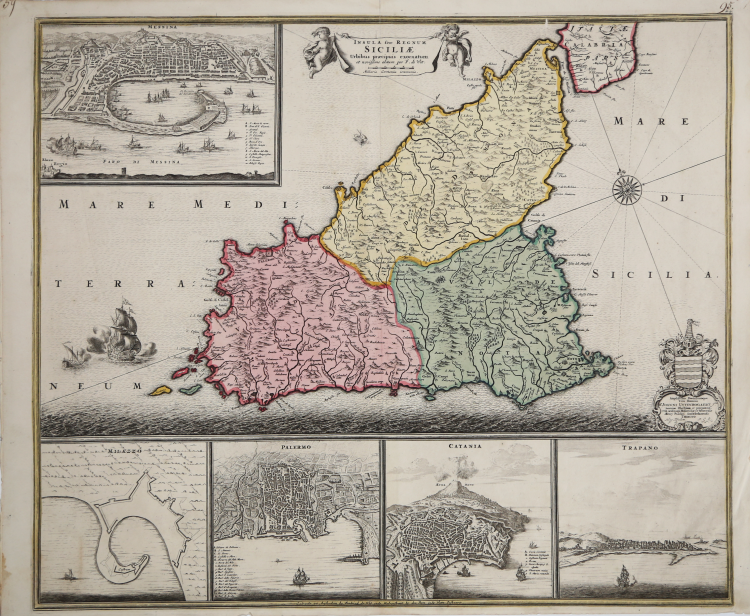
Map published for the first time in the Atlas Major, 1680 circa. It is decorated with cartouches depicting views and plans of Messina, Palermo, Catania and Trapani, and a plan of Messina erroneously called Milazzo. Due to the great outcome, the map was reissued in the first years of 1700 by Covens and Mortier and by the Ottens.
The quality of the colour and the paper make us presume it was published by Ottens, around 1730.
“Frederick de Wit (1630-1706), incisore e commerciante di mappe, era nativo di Gouda ma ottenne la cittadinanza di Amsterdam a seguito del matrimonio, nel 1661, con Maria van der Waag. In questa città lavorava già dal 1648.
Quasi tutti i suoi atlanti sono privi di data per cui la loro collocazione temporale è alquanto difficoltosa. Basta confrontare le raccolte della British Library, della Library of Congress e della Nordenkiöld Collection per rendersi conto dei difficili, a volte impossibili, confronti tra l'una e l'altre copie. Lo stesso Koeman, nel suo impareggiabile reperto- rio, è costretto a ordinare i suoi atlanti secondo il numero di mappe in essi presente. Una possibilità di datare le sin- gole mappe, o i frontespizi, proviene dalla concessione del privilegio a stampare, ottenuta nel 1689. In questa carta della Sicilia manca l'indicazione relativa al privilegio, circostanza che la collocherebbe a una data anteriore al 1689. Un altro termine temporale, post quem, potrebbe essere for- nito da un atlante di de Wit con 50 carte, pubblicato nel 1666, nel quale compare solo la "Tabula Italiae, Corsicae, Sardiniae" (Maritime Museum, n. 190).
Koeman riporta una copia dell'Atlas di de Wit, con 26 carte, dove compare l'isola di Sicilia, e lo data al 1680 [?], che assumo, pertanto, come possibile periodo di edizione della carta.
Entro la cornice, in basso al centro, compare la seguente scritta: "Gedruckt tot Amsterdam by Frederick de Wit inde Kalverstraet by den Dam inde Witte Paskaert", mentre nel cartiglio in basso a destra compare la dedica a Joannes Uy- tenbogaert sormontata dal suo stemma nobiliare.
La carta della Sicilia compare in via sporadica in atlanti compositi della fine del XVII secolo, come ad esempio quello conservato nella British Library, datato tra il 1693 e il 1694.
Parecchie delle mappe pubblicate da de Wit subirono modifiche nel corso degli anni, dall'aggiunta del privilegio, al reticolato con lettere per la ricerca dei luoghi, ma non sembra essere stata questa la sorte di questo rame della Sicilia: forse, anche a causa dell'orientamento non convenzionale, l'immagine dell'isola fu modificata intorno al 1695.” (cfr. V. Valerio in Sicilia 1477-1861, p. 300).
Copper engraving, in excellent condition.
Bibliografia
L. Dufour - A. La Gumina, "Imago Siciliae", p. 142; Valerio-Spagnolo "Sicilia 1477-1861", pp. 300-302, n. 131.
Frederick de WIT (1630 - 1706)
|
De Wit was one of the most prominent and successful map engravers and publishers in Amsterdam in the period following the decline of the Blaeu and Jansson establishments, from which he acquired many copper plates when they were dispersed at auction. His output covered most aspects of map making: sea charts, world atlases, an atlas of the Netherlands, 'town books' covering plans of towns and cities in the Netherlands and Europe, and wall maps. His work, notable for the beauty of the engraving and colouring, was very popular and editions were issued many years after his death by Pieter Mortier and Covens and Mortier.
|