
| Reference: | S43376 |
| Author | Benedetto MARZOLLA |
| Year: | 1857 |
| Zone: | Sicily |
| Printed: | Naples |
| Measures: | 665 x 510 mm |
| Reference: | S43376 |
| Author | Benedetto MARZOLLA |
| Year: | 1857 |
| Zone: | Sicily |
| Printed: | Naples |
| Measures: | 665 x 510 mm |
The Descrizione del Regno delle Due Sicilie, first published in 1854, is a cartographic update to the previous production of the cartographer himself.
Nonetheless, even more important in the atlas are orography, administrative division and read and train network.
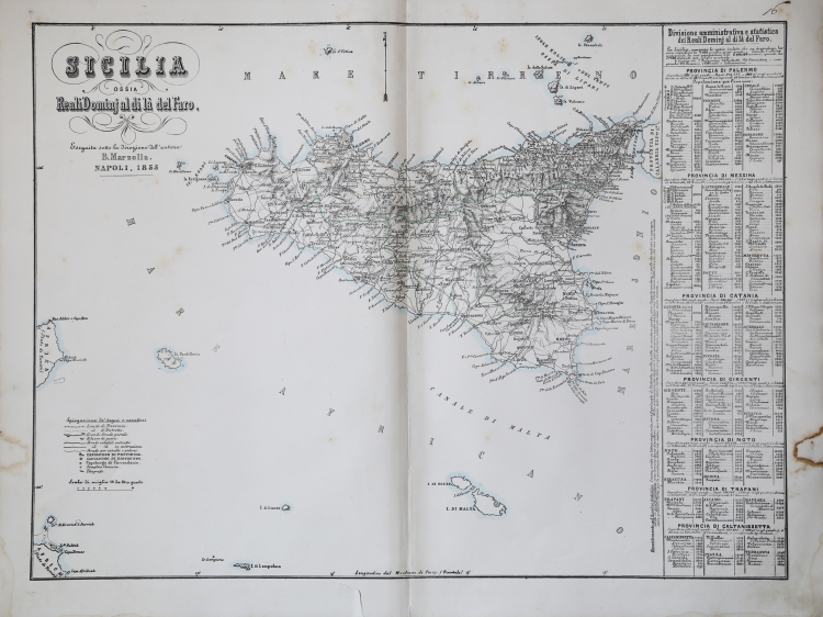
The 24 maps that form the collection are therefore the most important document on Southern regions, right before Italy was unified. Eight maps depict Sicily, divided in seven provinces.
Benedetto Marzolla was draftsman topographer and lithographer, geographer and cartographer. Character of great importance in the Neapolitan and Italian cartography of the nineteenth century, Marzolla obtained during his life public recognition and certificates for the production of high quality cartography. His notoriety slowly faded after his death; it should be noted, however, that only the lack of a strong political involvement in the sense of the Risorgimento and of a literary value in his work did not make him as famous as his contemporaries Francesco Costantino Marmocchi (1805-1858) and Attilio Zuccagni-Orlandini (1783-1872), with whom he can certainly compare himself. Marzolla's cultural, didactic and editorial projects were, and remain, extraordinarily modern; he invented a new way of understanding and drawing maps, providing an absolutely original vision of the communication of geographical data through the combination of text and image. With this operation, he was able to merge in a single work, history, geography, economics, statistics and cartography, achieving a graphic balance of rare effectiveness.
“La sua particolare scelta di unire testo e tavole è descritta con chiarezza alcuni anni dopo nella presentazione dell'atlante geografico: "abbiamo determinato di apporre sopra ciascuna tavola la descrizione fisica, sferica, politica, statistica delle varie regioni di cui la tavola presenta l'aspetto, sì che non sia d'uopo di svolgere altre carte e altri libri per gir rintracciando ciò che si brama di apprendere, il che produce un risparmio di fatica e di tempo, risparmio che riesce utile fuor di misura, tanto maggiormente da che sì breve è l'umana vita, e così lunga l'estensione del sapere" (Giornale delle Due Sicilie, 13 novembre 1840 cit. in Valerio 2008: 25)
Per la prima volta Napoli disponeva di un dettagliato atlante regionale, redatto in scala 1:400.000 circa, e corredato di notizie storiche, statistiche, economiche e amministrative. L'accoglimento da parte del pubblico fu lusinghiero e, nel 1837, Marzolla ne curò una seconda edizione, alla quale aggiunse la "Delegazione di Pontecorvo" (1837) e la "Delegazione di Benevento" (1833). Il Valle Minore di Palermo ebbe un'ulteriore edizione con la data modificata al 1832. […]
La carta dell'intera isola fu l'ultima a essere stampata nel 1853, un anno prima del termine dell'atlante e della pubblicazione del frontespizio. Questa carta è l'unica ad avere marcate alla cornice le coordinate geografiche. Data la scala corografica, l'autore riesce a far confluire un gran numero di informazioni sulla rete viaria, sui rilievi di posta, sui confini amministrativi delle province e dei distretti arrivando anche a indicare la posizione dei "telegrafi". Questa carta ebbe una ulteriore tiratura nella quale la data è modificata in 1857.” (Valerio-Spagnolo "Sicilia 1477-1861", p. 692).
Litograph with original outline colour, very good condition.
Bibliografia:
Valerio, Benedetto Marzolla. Brindisino, Geografo e Cartografo dell’800 Europeo, n. 149; Tooley,s Dictionary, p. 216; Valerio-Spagnolo "Sicilia 1477-1861", pp. 692-693, n. 368.
Benedetto MARZOLLA (Brindisi, 1801 - Napoli, 1858)
|
Designer surveyor and lithographer, and cartographer, geographer and member of the Commission of Statistics, Ministry of Interior. Character of great importance in the Neapolitan and Italian maps of the nineteenth century, Marzolla won awards and certificates in public life for the cartographic production of high quality. His reputation has slowly dissolved after death, it should be observed that only the lack of a strong political involvement in the Risorgimento and the sense of literary value in his work not made him famous contemporaries such as Francesco Costantino Marmocchi (1805-1858) and Attilio Zuccagni Orlandini (1783-1872), with which it can certainly deal with. Cultural projects and educational publishing Marzolla were and remain extraordinary modernity, he invented, it is appropriate to say, a new way of understanding and to draw the map, providing a totally original data communication through a combination of geographic text and image. With this, he managed to merge into a single work, history, geography, economics, statistics and maps, reaching an equilibrium graph with outstanding performance.
(Cfr. by V. Valerio, Benedetto Marzolla Brindisi,Geografo e Cartografo dell' 800 Europeo, Brindisi 2008)
|