| Reference: | S51210.6 |
| Author | Jacob Aertsz COLOM |
| Year: | 1638 |
| Zone: | Cagliari |
| Printed: | Amsterdam |
| Measures: | 270 x 210 mm |
| Reference: | S51210.6 |
| Author | Jacob Aertsz COLOM |
| Year: | 1638 |
| Zone: | Cagliari |
| Printed: | Amsterdam |
| Measures: | 270 x 210 mm |
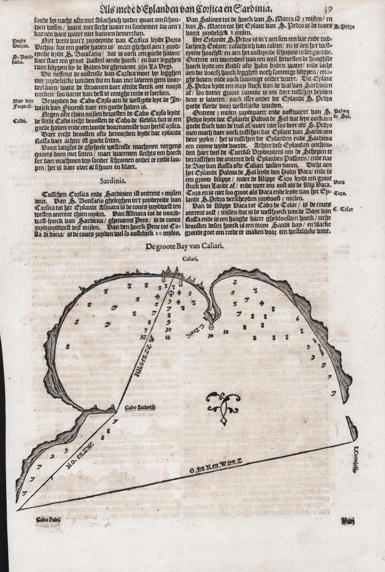
Woodcut map of the city, inserted into a text page published in the third and final volume of Jacob Aertsz Colom's nautical atlas of the Mediterranean, Der Vyerighe Colom, a Dutch edition, published in Amsterdam in 1638.
This is one of the very first nautical charts of the city.
Jacob Aertsz Colom entered the map market during the golden age of Dutch cartography and had to work hard to stand out among the other mapmakers of the time. He began making globes in the early 1630s, producing three different pairs of spheres, derived from Jodocus Hondius. While the large printing houses of Blaeu and Janssonius competed to publish increasingly large and lavish atlases, Colom seized the opportunity to enter the cartographic production market, identifying a commercially profitable niche in nautical guides and portolans. His first nautical atlas was Der Vyerighe Colom (1632), a large collection in three parts whose title – to paraphrase his own surname – meant “the fiery column”. In the text, he provocatively announced that he was correcting errors found in Blaeu's Zeespiegel. Blaeu responded by publishing his Havenwyser (1634), in which he accused Colom of plagiarism. However, Blaeu's hasty replication of De Vyerighr Colom with maps from earlier works failed to curb Colom's success; De Vyerighr Colom was translated into French and English and went into 34 editions. Colom also produced an enlarged oblong version of De Vyerighr Colom before attempting a completely new work: the Atlas of Werelts-Water-Deel. Unlike his guidebook, this nautical atlas covered the entire world; it was evidently a commercial response to other Dutch map producers.
Extremely rare sheet. In excellent condition.
Bibliografia
Jason Hubbard, Atlas Maritimo o Mundo Aquatico, 1668 by Jacob Aertz. Colom, in “Map Forum”, Issue 12, Londra 2005; C. Koeman, Atlantes Neerlandici: Bibliography of Terrestrial, Maritime and Celestial Atlases and Pilot Books Published in the Netherlands up to 1880 Vol. IV, pp. 119-124, J. Col 6 A (29, 30); cfr. National Maritime Museum, Catalogue of the Library - Vol. Three, Atlas & Cartography, Londra, 1971, p. 68, n. 76; cfr. R. Shirley, Maps in the Atlases of the British Library, Londra, 2004, pp. 1080-1082; S. Bifolco, "Mare Nostrum, Cartografia nautica a stampa del Mar Mediterraneo" (2020), pp. 132-35.
Jacob Aertsz COLOM (1600-70 circa)
|
Jacob Colom was a printer, bookseller, chart and globe maker who set out to challenge the virtual monopoly held by W. J. Blaeu, then the only chart maker in Amsterdam.
His Pilot Guide De Vyerighe Colom published in various formats and languages (with exotic tides) to meet the demands of the time was highly successful and forced Blaeu to revise and enlarge his existing chart books. In spite of Blaeu's efforts, Colom's Guide remained popular with seamen for many years and although the charts were issued in great quantity, they are now extremely
|