
| Reference: | S49981 |
| Author | Eredi Johannes Baptiste HOMANN |
| Year: | 1762 |
| Zone: | Sicily, Sardinia, Corsica |
| Printed: | Nurnberg |
| Measures: | 595 x 485 mm |
| Reference: | S49981 |
| Author | Eredi Johannes Baptiste HOMANN |
| Year: | 1762 |
| Zone: | Sicily, Sardinia, Corsica |
| Printed: | Nurnberg |
| Measures: | 595 x 485 mm |
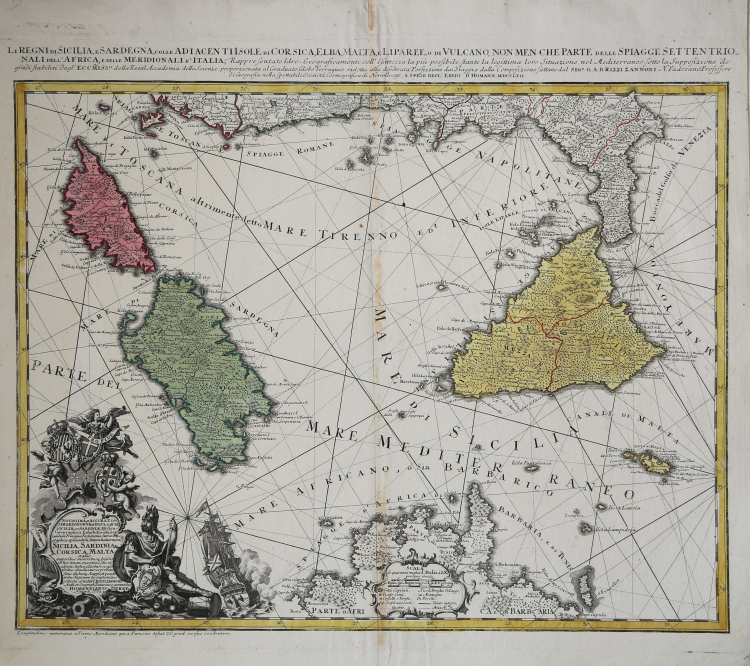
Li Regni di Sicilia e Sardegna colle Adiacenti Isole di Corsica, Elba, Malta e Liparee, o di Vulcano, non men che parte delle spiagge settentrionali dell'Africa e delle Meridionali d'Italia, Rappresentate Idro- Geograficamente e all'esattezza la più possibile, stante la legittima loro Situazione nel Mediterraneo sotto la Supposizione dei grandi stabiliti dagl'Eccmiss.mi della Reial Accademia delle Scienze, proporzionata al Graduato Globo Terraqueo: ridotta alla desiderata Perfezione dai Viaggi e dalla composizione fattane dal Sig. e G.A.B. Rizzi Zannoni N. Padovano Professore di Geografia nella spettabile Società Cosmografica di Norimbergo, A spese degl' Eredi d'Homann MDCCLXII.
This superbly detailed map, engraved by Homann Heirs in 1762 based on the work of Giovanni Antonio Bartolomeo Rizzi-Zannoni, is among the finest and most appealing maps of Corsica, Sicily and Sardinia. The map encompasses the Mediterranean from Corsica to Malta and the Gulf of Venice, and from the west coast of Italy to the Tunisian coast of Africa. The map's complex stereographic projection allows the presentation of the three main islands of the map to be presented as if on a plane, while necessarily distorting the areas at the edge of the map; it is also generally oriented to the northeast, resulting in the unusual and symmetrical presentation of the region. The map is significantly more complex and detailed than previous Homann or Homann Heirs maps; this is due to the work of the Italian cartographer Rizzi-Zannoni, who in 1757 had traveled to Germany to enter the service of Prussia during the Seven Years' War.
The elaborate cartouche in the lower left quadrant, accompanied by a fine sailing ship, displays the armorial shields of Sicily, Sardinia and Malta. A warrior reclines beside the cartouche, probably Mars but possibly Perseus: he bears a shield decorated with Medusa's head. Perseus slew the Gorgon Medusa using Athena's mirrored shield to avoid being stoned (as everybody must be) but Medusa's head is displayed as an aegis on Athena's shield often in classical art, so presumably the shield is hers. The bearded warrior is in no way Athena, so perhaps her shield is here on loan again.
The map was engraved in 1762, and would be included in Homann Heirs atlases.
Eredi Johannes Baptiste HOMANN (1730 - 1813)
|
Johann Baptist Homann (20 March 1664 – 1 July 1724) was a German geographer and cartographer
born in Oberkammlach near Kammlach in the Electorate of Bavaria. Although educated at a Jesuit school, and preparing for an ecclesiastical career, he eventually converted to Protestantism and from 1687 worked as a civil law notary in Nuremberg. He soon turned to engraving and cartography; in 1702 he founded his own publishing house. Homann acquired renown as a leading German cartographer, and in 1715 was appointed Imperial Geographer by Emperor Charles VI. Giving such privileges to individuals was an added right that the Holy Roman Emperor enjoyed. In the same year he was also named a member of the Prussian Academy of Sciences in Berlin. Of particular significance to cartography were the imperial printing privileges (Latin: privilegia impressoria). These protected for a time the authors in all scientific fields such as printers, copper engravers, map makers and publishers. They were also very important as a recommendation for potential customers. In 1716 Homann published his masterpiece Grosser Atlas ueber die ganze Welt (Grand Atlas of all the World). Numerous maps were drawn up in cooperation with the engraver Christoph Weigel the Elder, who also published Siebmachers Wappenbuch. Homann died in Nuremberg in 1724. He was succeeded by his son Johann Christoph (1703-1730). The company carried on upon his death as Homann heirs company, managed by Johann Michael Franz and Johann Georg Ebersberger. After subsequent changes in management the company folded in 1852. The company was known as "Homann Erben", "Homanniani Heredes", or "Heritiers de Homann" abroad.
1702-07 Atlas novus terrarum
1712 Enlarged edition with re-issues to c.1753
c.1714 Neuer Atlas
re-issues to c. 1730
1719 Atlas Methodicus
1730 America Septentrionali Britannorum
1737 Grosser atlas
re-issues to c. 1770
|