| Reference: | MMS628 |
| Author | Pierre MORTIER |
| Year: | 1700 ca. |
| Zone: | Sardinia |
| Printed: | Amsterdam |
| Measures: | 605 x 500 mm |
| Reference: | MMS628 |
| Author | Pierre MORTIER |
| Year: | 1700 ca. |
| Zone: | Sardinia |
| Printed: | Amsterdam |
| Measures: | 605 x 500 mm |
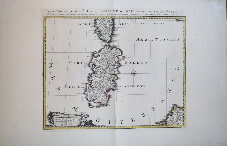
Carta geografica della Sardegna, con la parte meridionale della Corsica.
La carta deriva dal cartografo francese Nicolas Sanson, che per il disegno dell’isola si basa sulla carta di Giovanni Antonio Magini, ed è pubblicata ad Amsterdam da Pierre Mortier nel suo Atlas Nouveau.
Sebbene circoli separatamente, questa carta costituisce uno dei quattro fogli che compongono una grande carta d’Italia.
Graduata ai margini e presenta cinque scale grafiche inserite in un bel cartiglio sorretto da figure mostruose: Mille Pas Geom' ou Milles d'Italie; Milles d'Angleterre; Lieues Communes de France; Lieues Royales de France; Lieues Communes d'Allemagne. Ad Est della Sardegna è una rosa dei venti a 8 direzioni, decorata con i tipici rombi e sormontata da un giglio che segna il Nord. L’Est è invece segnato da una crocetta. La Sardegna, di chiara matrice maginiana, presenta un interno prevalentemente montuoso, affollato da piccoli mucchi di talpa, interrotti da numerosi fiumi dal corso sinuoso. Le coste sono leggermente tratteggiale sul lato esterno. I centri abitati presentano diversi simboli a seconda della loro importanza e sono talvolta sormontati da una piccola croce se il luogo è anche sede vescovile o arcivescovile. Una serie di quadratini indica le saline.
Pierre Mortier (1661 - 1711) o Pieter Mortier è stato un cartografo, incisore e venditore di stampe attivo ad Amsterdam tra la fine del XVII e l'inizio del XVIII secolo. Mortier, allora noto come Pieter, nacque a Leida. Si trasferì a Parigi dal 1681 al 1685, adottando il nome francese Pierre, che mantenne per tutta la sua carriera. Durante la sua permanenza in Francia, sviluppò profondi legami francesi portando la sofisticata tecnologia di stampa e l'esperienza olandese ai nascenti editori di mappe francesi come Guillaume De L'Isle (1675 - 1726), Alexis-Hubert Jaillot (1632 circa - 1712) e Nicholas de Fer (1646 - 1720). Di conseguenza, gran parte dell'attività di Mortier si basava sulla pubblicazione di edizioni abbellite di alta qualità di mappe francesi contemporanee, generalmente con il permesso degli autori originali. Nel contesto generale della cartografia mondiale, questo era un vantaggio significativo, poiché la maggior parte delle case editrici di carte olandesi era ormai caduta nel miasma della ristampa delle proprie opere obsolete. Al contrario, i cartografi francesi producevano le carte più accurate e aggiornate del mondo. Il lavoro cartografico di Mortier culminò nel magnifico atlante nautico Le Neptune Francois. Nel 1690 gli fu conferito il Privilegio, una prima forma di diritto d'autore. Alla morte di Pierre, nel 1711, l'attività fu ereditata dalla vedova. Nel 1721, il figlio Cornelius Mortier assunse la gestione quotidiana dell'azienda. Cornelius si associò al cognato Jean Covens per formare una delle più grandi società cartografiche della storia - Covens e Mortier - che continuò a pubblicare mappe e atlanti fino al 1866 circa.
Incisione in rame, coloritura coeva dei contorni, margini, leggere pieghe di carta, nel complesso in ottimo stato di conservazione.
|
Tooley p. 450; Cremonini scheda 54, 237.
|
|
Pierre Mortier (January 26, 1661 - February 18, 1711) or Pieter Mortier was a cartographer, engraver, and print seller active in Amsterdam during the later 17th and early 18th centuries. Mortier, then known as Pieter, was born in Leiden. He relocated to Paris from 1681 to 1685, adopting the French name Pierre, which he retained throughout his career. While in France, he developed deep French connections by bringing sophisticated Dutch printing technology and experience to nascent French map publishers such as Guillaume De L'Isle (1675 - 1726), Alexis-Hubert Jaillot (c. 1632 - 1712), and Nicholas de Fer (1646 - 1720). Consequently, much of Mortier's business was built upon issuing embellished high quality editions of contemporary French maps - generally with the permissions of their original authors. In the greater context of global cartography, this was a significant advantage as most Dutch map publishes had, at this point, fallen into the miasma of reprinting their own outdated works. By contrast, the cartographers of France were producing the most accurate and up to date charts anywhere. Mortier's cartographic work culminated in the magnificent nautical atlas, Le Neptune Francois. He was awarded the Privilege, an early form of copyright, in 1690. Upon Pierre's death in 1711 this business was inherited by his widow. In 1721, his son Cornelius Mortier took over the day to day operation of the firm. Cornelius partnered with his brother-in-law Jean Covens to form one of history's great cartographic partnerships - Covens and Mortier - which continued to publish maps and atlases until about 1866.
|
|
Tooley p. 450; Cremonini scheda 54, 237.
|
|
Pierre Mortier (January 26, 1661 - February 18, 1711) or Pieter Mortier was a cartographer, engraver, and print seller active in Amsterdam during the later 17th and early 18th centuries. Mortier, then known as Pieter, was born in Leiden. He relocated to Paris from 1681 to 1685, adopting the French name Pierre, which he retained throughout his career. While in France, he developed deep French connections by bringing sophisticated Dutch printing technology and experience to nascent French map publishers such as Guillaume De L'Isle (1675 - 1726), Alexis-Hubert Jaillot (c. 1632 - 1712), and Nicholas de Fer (1646 - 1720). Consequently, much of Mortier's business was built upon issuing embellished high quality editions of contemporary French maps - generally with the permissions of their original authors. In the greater context of global cartography, this was a significant advantage as most Dutch map publishes had, at this point, fallen into the miasma of reprinting their own outdated works. By contrast, the cartographers of France were producing the most accurate and up to date charts anywhere. Mortier's cartographic work culminated in the magnificent nautical atlas, Le Neptune Francois. He was awarded the Privilege, an early form of copyright, in 1690. Upon Pierre's death in 1711 this business was inherited by his widow. In 1721, his son Cornelius Mortier took over the day to day operation of the firm. Cornelius partnered with his brother-in-law Jean Covens to form one of history's great cartographic partnerships - Covens and Mortier - which continued to publish maps and atlases until about 1866.
|