
| Reference: | S40017 |
| Author | Antonio ZATTA |
| Year: | 1795 ca. |
| Zone: | Poland |
| Printed: | Venice |
| Measures: | 330 x 245 mm |
| Reference: | S40017 |
| Author | Antonio ZATTA |
| Year: | 1795 ca. |
| Zone: | Poland |
| Printed: | Venice |
| Measures: | 330 x 245 mm |
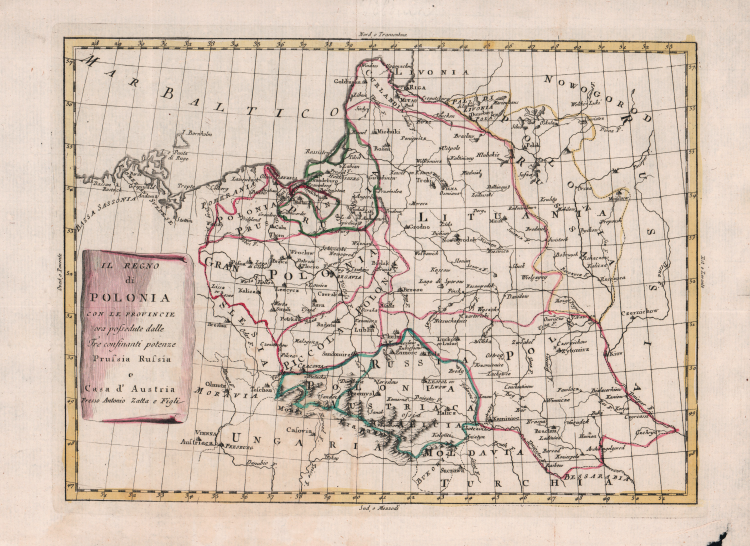
Rare map of Poland, in the midst of its dismemberments. Although undated, the map is traced back to around 1795 for historical reasons.
The Partitions of Poland were three partitions of the Polish–Lithuanian Commonwealth that took place toward the end of the 18th century and ended the existence of the state, resulting in the elimination of sovereign Poland and Lithuania for 123 years. The partitions were conducted by the Habsburg Monarchy, the Kingdom of Prussia, and the Russian Empire, which divided up the Commonwealth lands among themselves progressively in the process of territorial seizures and annexations.
The First Partition of Poland was decided on August 5, 1772. Two decades later, Russian and Prussian troops entered the Commonwealth again and the Second Partition was signed on January 23, 1793. Austria did not participate in the Second Partition. The Third Partition of Poland took place on October 24, 1795, in reaction to the unsuccessful Polish Kościuszko Uprising the previous year. With this partition, the Commonwealth ceased to exist.
The map locates the Polish territorial acquistions of Russia, Austria and Prussia in the second half of the 18th Century.
The map of present-day Poland, Lithuania, and portions of Latvia, Belarus, and Ukraine, identifying the cities of Warsaw, Krakow, Kiev, Minsk, and Riga, extending into Austria to show Vienna.
Etching, original outline colour, in good condition.
Antonio ZATTA (Venezia 1722 - 1804)
|
Antonio Zatta (1775-1797) was the most prominent Italian map publisher of the late 18th and early 19th century. His firm, based in Venice, produced maps that mark an important transition from 18th to 19th century cartographic styles. He updates and redefines the traditional title cartouche by replacing the mythic elements common to the 17th and 18th century with more representative images of Venice. His most important work is the four volume Atlante novissimo published from 1775 to 1789.
|